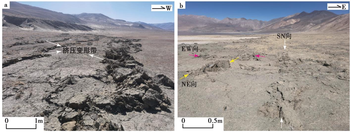
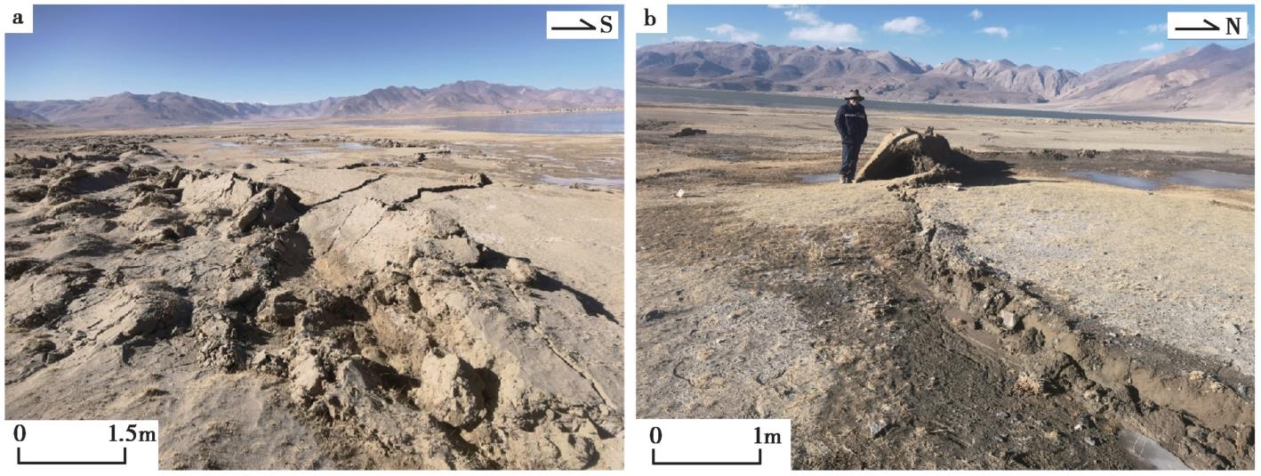
| [1] |
卞爽, 于志泉, 龚俊峰, 等. 2021. 青藏高原近SN向裂谷的时空分布特征及动力学机制[J]. 地质力学学报, 27(2): 178—194.
|
|
BIAN Shuang, YU Zhi-quan, GONG Jun-feng, et al. 2021. Spatiotemporal distribution and geodynamic mechanism of the nearly NS-trending rifts in the Tibetan plateau[J]. Journal of Geomechanics, 27(2): 178—194 (in Chinese).
|
| [2] |
才巴央增, 赵俊猛. 2018. 藏南裂谷系的研究综述[J]. 地震研究, 41(1): 14—21, 157.
|
|
CAIBA Yang-zeng, ZHAO Jun-meng. 2018. A summary of researches on southern Tibet rift system[J]. Journal of Seismological Research, 41(1): 14—21, 157 (in Chinese).
|
| [3] |
裴庆锋. 2020. 昂仁北西地区当穹错-当惹雍错-许如错SN向新近纪—第四纪地堑演化机制及地貌响应[D]. 成都: 成都理工大学.
|
|
PEI Qing-feng. 2020. Evolutionary mechanism and geomorphic responses of Dangqiong wrong-Dang yong co-Xu Rucuo north-south Neogene-Quaternary graben in the northwestern Angren[D]. Chengdu University of Technology, Chengdu. (in Chinese)
|
| [4] |
|
|
SHI Feng, LIANG Ming-jian, LUO Quan-xing, et al. 2025. Seismogenic fault and coseismic surface deformation of the Dingri MS6.8 earthquake in Tibet, China[J]. Seismology and Geology, 47(1): 1—15 (in Chinese).
|
| [5] |
田婷婷, 吴中海. 2023. 西藏申扎-定结裂谷南段丁木错正断层的最新史前大地震事件及其地震地质意义[J]. 地质论评, 69(1): 53—55.
|
|
TIAN Ting-ting, WU Zhong-hai. 2023. Recent prehistoric major earthquake event of Dingmucuo normal fault in the southern segment of Shenzha-Dingjie Rift and its seismic geological significance[J]. Geological Review, 69(1): 53—55 (in Chinese).
|
| [6] |
吴章明, 曹忠权, 申屠炳明, 等. 1990. 西藏申扎南发现地震地表破裂[J]. 地震地质, 12(4): 317—318, 389.
|
|
WU Zhang-ming, CAO Zhong-quan, SHENTU Bing-ming, et al. 1990. Surface ruptures by earthquakes found in Xainza, Central Xizang[J]. Seismology and Geology, 12(4): 317—318, 389 (in Chinese).
|
| [7] |
吴中海, 叶培盛, 王成敏, 等. 2015. 藏南安岗地堑的史前大地震遗迹、年龄及其地质意义[J]. 地球科学, 40(10): 1621—1642.
|
|
WU Zhong-hai, YE Pei-sheng, WANG Cheng-min, et al. 2015. The relics, ages and significance of prehistoric large earthquakes in the Angang Graben in South Tibet[J]. Earth Science, 40(10): 1621—1642 (in Chinese).
|
| [8] |
徐心悦. 2019. 藏南申扎-定结断裂系卡达正断裂晚第四纪活动性及其环境效应[D]. 北京: 中国地震局地质研究所.
|
|
XU Xin-yue. 2019. Late Quaternary activity and its environmental effects of the N-S trend Kharta fault in Xainza-Dinggye rift, Southern Tibet[D]. Institute of Geology, Beijing (in Chinese).
|
| [9] |
杨攀新, 任金卫, 陈正位, 等. 2010. 西藏中部申扎-定结地堑系北段中新世以来构造地貌学研究[J]. 地震, 30(3): 81—89.
|
|
YANG Pan-xin, REN Jin-wei, CHEN Zheng-wei, et al. 2010. Tectonic geomorphology of the northern segment of Shenzha-Dingjie Graben since Miocene in middle Tibetan plateau[J]. Earthquake, 30(3): 81—89 (in Chinese).
|
| [10] |
张佳伟, 李汉敖, 张会平, 等. 2020. 青藏高原新生代SN走向裂谷研究进展[J]. 地球科学进展, 35(8): 848—862.
|
|
ZHANG Jia-wei, LI Han-ao, ZHANG Hui-ping, et al. 2020. Research progress in Cenozoic N-S striking rifts in Tibetan plateau[J]. Advances in Earth Science, 35(8): 848—862 (in Chinese).
|
| [11] |
张进江, 郭磊, 丁林. 2002. 申扎-定结正断层体系中、南段构造特征及其与藏南拆离系的关系[J]. 科学通报, 47(10): 738—743.
|
|
ZHANG Jin-jiang, GUO Lei, DING Lin. 2002. Structural characteristics of the middle and south sections of Shenzha-Dingjie normal fault system and their relationship with the southern Tibet separation system[J]. Chinese Science Bulletin, 47(10): 738—743 (in Chinese).
|
| [12] |
左嘉梦. 2021. 西藏亚东-谷露裂谷南段冲巴雍错正断层晚第四纪活动特征研究[D]. 北京: 中国地质大学(北京).
|
|
ZUO Jia-meng. 2021. Late Quaternary activity characteristics of the ChongbaYumtso normal fault in the southern section of the Yadong-Gullu Rift, Tibet[D]. China University of Geosciences(Beijing), Beijing. (in Chinese).
|
| [13] |
Armijo R, Tapponnier P, Mercier J L, et al. 1986. Quaternary extension in southern Tibet: Field observations and tectonic implications[J]. Journal of Geophysical Research: Solid Eart, 91(B14): 13803—13872.
|
| [14] |
Chen H, Qu C Y, Zhao D Z, et al. 2024. Large-scale extensional strain in Southern Tibet from Sentinel-1 InSAR and GNSS data[J]. Geophysical Research Letters, 51(19): e2024GL110512.
|
| [15] |
Chevalier M L, Tapponnier P, van der Woerd J, et al. 2020. Late Quaternary extension rates across the northern half of the Yadong-Gulu Rift: Implication for east-west extension in Southern Tibet[J]. Journal of Geophysical Research: Solid Earth, 125(7): e2019JB019106. doi: 10.1029/2019JB019106.
|
| [16] |
Choi J H, Jin K, Enkhbayar D, et al. 2012. Rupture propagation inferred from damage patterns, slip distribution, and segmentation of the 1957 MW8.1 Gobi-Altay earthquake rupture along the Bogd Fault, Mongolia[J]. Journal of Geophysical Research: Solid Earth, 117(B12): B12041.
|
| [17] |
Choi J, Klinger Y, Ferry M, et al. 2018. Geologic inheritance and earthquake rupture processes: the 1905 M≥8 Tsetserleg-Bulnay strike-slip earthquake sequence, Mongolia[J]. Journal of Geophysical Research: Solid Earth, 123(6B): 1925—1953.
|
| [18] |
Ha G H, Wu Z H, Liu F. 2019. Late Quaternary vertical slip rates along the Southern Yadong-Gulu Rift, Southern Tibetan plateau[J]. Tectonophysics, 755: 75—90.
|
| [19] |
Kali E, Leloup P, Arnaud N, et al. 2010. Exhumation history of the deepest central Himalayan rocks, Ama Drime range: Key pressure-temperature-deformation-time constraints on orogenic models[J]. Tectonics, 29(2): 1—31.
|
| [20] |
Kali E, Van D W, LIU-ZENG J, et al. 2012. Active normal faults and river damming: The importance of tectonics and climate in shaping the landscape of the southern Tibetan plateau[C]. EGU General Assembly Conference Abstracts.
|
| [21] |
Monsalve G, Sheehan A, Schulte-Pelkum V, et al. 2006. Seismicity and one-dimensional velocity structure of the Himalayan collision zone: Earthquakes in the crust and upper mantle[J]. Journal of Geophysical Research, 111(B10): 0148—0227.
|
| [22] |
Wang H, Elliott J R, Craig T J, et al. 2014. Normal faulting sequence in the Pumqu-Xainza Rift constrained by InSAR and teleseismic body-wave seismology[J]. Geochemistry, Geophysics, Geosystems, 15(7): 2947—2963.
|
| [23] |
Wang H, Wright T J, Jing L Z, et al. 2019. Strain rate distribution in south-central Tibet from two decades of InSAR and GPS[J]. Geophysical Research Letters, 46(10): 5170—5179.
|
| [24] |
Wang M, Shen Z K. 2020. Present-day crustal deformation of continental China derived from GPS and its tectonic implications[J]. Journal of Geophysical Research: Solid Earth, 125(2): e2019JB018774.
|
| [25] |
Yin A. 2000. Mode of Cenozoic east-west extension in Tibet suggesting a common origin of rifts in Asia during the Indo-Asian collision[J]. Journal of Geophysical Research: Solid Earth, 105(B9): 21745—21759.
|
 ), DONG Yun-xi1), ZUO Hong1), DAI You-lin1), XIAO Ben-fu1), LIAO Cheng1), TAN Ling1), WANG Yu-wei1), LI Xiang1), TANG Cai-cheng2), ZHANG Wei1), ZHANG Hui-ping3), MENG Ling-yuan4), SU Jin-rong1), WU Wei-wei1), LI Chuan-you3), YAN Mei2)