SEISMOLOGY AND GEOLOGY ›› 2024, Vol. 46 ›› Issue (3): 739-755.DOI: 10.3969/j.issn.0253-4967.2024.03.013
• Application of new technique • Previous Articles Next Articles
SONG Dong-mei1)( ), WANG Hao1),*(), FENG Jia-xing2), SHAN Xin-jian3), WANG Bin1)
Received:2023-02-14
Revised:2023-03-29
Online:2024-06-20
Published:2024-07-19
宋冬梅1)(), 王浩1),*(), 冯家兴2), 单新建3), 王斌1)
通讯作者:
*王浩, 男, 1997年生, 硕士, 主要从事三维激光点云地物提取方面的研究, E-mail: z20160115@s.upc.edu.cn。
作者简介:宋冬梅, 女, 1973年生, 2003年于中国科学院沈阳应用生态研究所获景观生态学专业博士学位, 教授, 现主要研究方向为海洋灾害遥感与遥感影像智能算法研究, E-mail: songdongmei@upc.edu.cn。
基金资助:SONG Dong-mei, WANG Hao, FENG Jia-xing, SHAN Xin-jian, WANG Bin. A FRACTURE ZONE EXTRACTION METHOD FOR LIDAR POINT CLOUD BASED ON MULTI-SCALE NEURAL NETWORK WITH RS-CONV[J]. SEISMOLOGY AND GEOLOGY, 2024, 46(3): 739-755.
宋冬梅, 王浩, 冯家兴, 单新建, 王斌. 基于RS-Conv的多尺度神经网络LiDAR点云断裂带提取方法[J]. 地震地质, 2024, 46(3): 739-755.
Add to citation manager EndNote|Ris|BibTeX
URL: https://www.dzdz.ac.cn/EN/10.3969/j.issn.0253-4967.2024.03.013
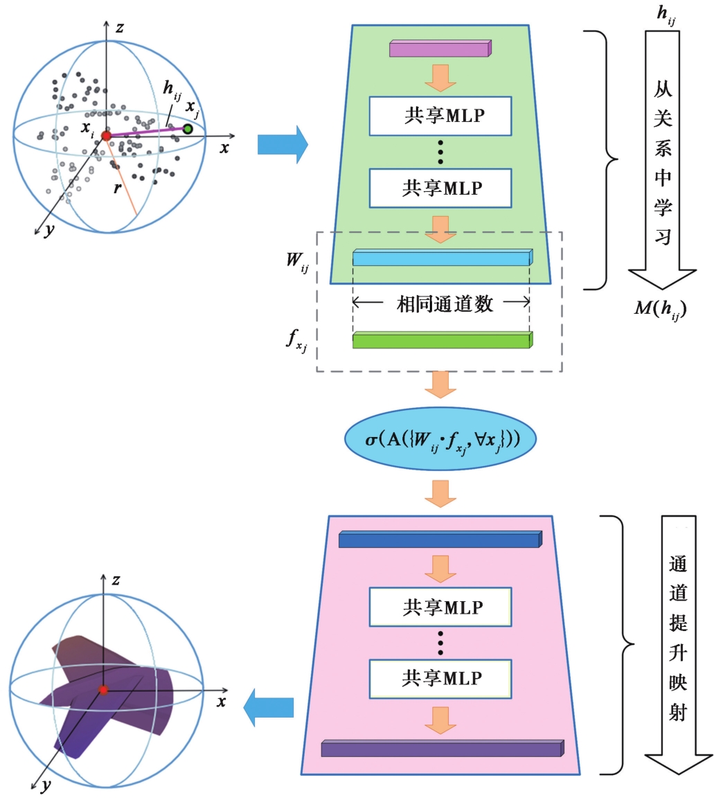
Fig. 1 Schematic diagram of RS-Conv operator framework.
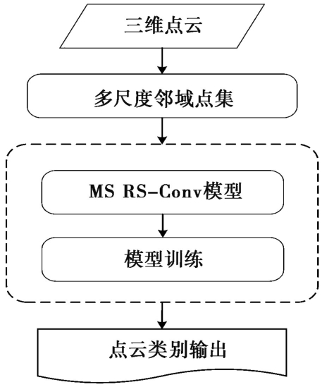
Fig. 2 Flowchart of LiDAR point cloud fracture zone extraction method.
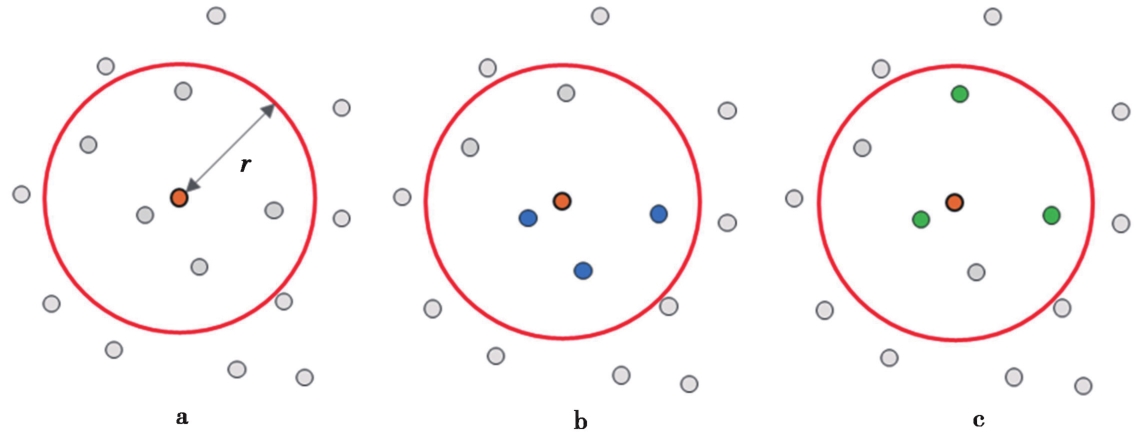
Fig. 3 Two-dimensional schematic diagram of the neighborhood search.
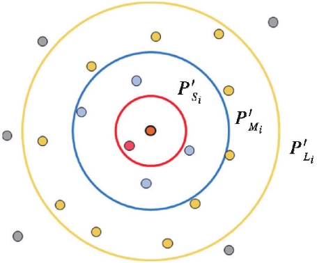
Fig. 4 Two-dimensional schematic diagram of multi-scale neighborhood search.
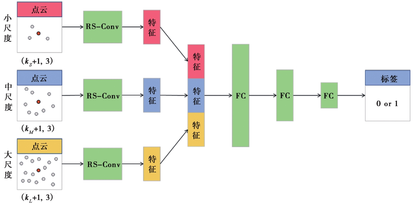
Fig. 5 Schematic diagram of MS RS-Conv point cloud fracture zone extraction framework.
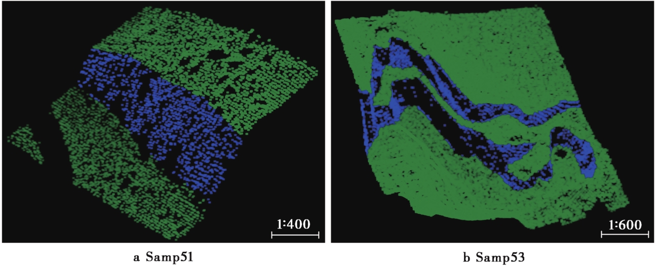
Fig. 6 Sample display diagrams of ISPRS point cloud dataset.
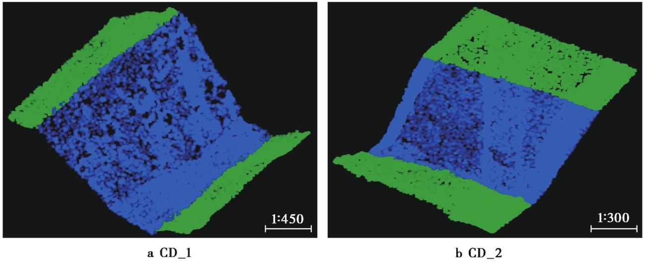
Fig. 7 Sample display diagrams of Chuandian point cloud dataset.
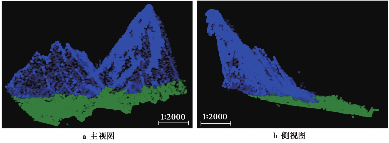
Fig. 8 Sample display diagrams of Xianshuihe point cloud dataset.
| 分类结果 | 预测 | |||
|---|---|---|---|---|
| 断裂带点 | 非断裂带点 | |||
| 真值 | 断裂带点 | a | b | |
| 非断裂带点 | c | d | ||
| Ⅰ类误差 | c/(c+d) | |||
| Ⅱ类误差 | b/(a+b) | |||
| 总误差 | (b+c)/(a+b+c+d) | |||
Table1 The confusion matrix of classification results and error calculation method
| 分类结果 | 预测 | |||
|---|---|---|---|---|
| 断裂带点 | 非断裂带点 | |||
| 真值 | 断裂带点 | a | b | |
| 非断裂带点 | c | d | ||
| Ⅰ类误差 | c/(c+d) | |||
| Ⅱ类误差 | b/(a+b) | |||
| 总误差 | (b+c)/(a+b+c+d) | |||
| 模型 | 邻域点搜索策略 | 邻域点个数 | 总误差/% | 提取精度/% |
|---|---|---|---|---|
| MS RS-Conv | kNN | 64、128、256 | 1.27 | 98.73 |
| 64、128、512 | 0.52 | 99.48 | ||
| 64、256、1024 | 1.24 | 98.76 | ||
| RPIB | 64、128、256 | 1.46 | 98.54 | |
| 64、128、512 | 0.99 | 99.01 | ||
| 64、256、1024 | 1.51 | 98.49 |
Table2 Results of fracture zone points extraction based on different search strategies and the number of neighborhood points
| 模型 | 邻域点搜索策略 | 邻域点个数 | 总误差/% | 提取精度/% |
|---|---|---|---|---|
| MS RS-Conv | kNN | 64、128、256 | 1.27 | 98.73 |
| 64、128、512 | 0.52 | 99.48 | ||
| 64、256、1024 | 1.24 | 98.76 | ||
| RPIB | 64、128、256 | 1.46 | 98.54 | |
| 64、128、512 | 0.99 | 99.01 | ||
| 64、256、1024 | 1.51 | 98.49 |
| 数据集 | 方法 | Ⅰ类误差/% | Ⅱ类误差/% | 总误差/% | 提取精度/% |
|---|---|---|---|---|---|
| Samp51 | 张量分解 | 1.22 | 9.31 | 2.82 | 97.18 |
| DNN | 0.46 | 4.95 | 1.35 | 98.65 | |
| MS RS-Conv | 0.41 | 2.56 | 0.86 | 99.14 | |
| Samp53 | 张量分解 | 2.43 | 17.37 | 3.83 | 96.17 |
| DNN | 1.07 | 11.39 | 2.03 | 97.97 | |
| MS RS-Conv | 0.19 | 10.27 | 1.04 | 98.96 |
Table3 Performance comparison of three fracture zone extraction methods on ISPRS dataset
| 数据集 | 方法 | Ⅰ类误差/% | Ⅱ类误差/% | 总误差/% | 提取精度/% |
|---|---|---|---|---|---|
| Samp51 | 张量分解 | 1.22 | 9.31 | 2.82 | 97.18 |
| DNN | 0.46 | 4.95 | 1.35 | 98.65 | |
| MS RS-Conv | 0.41 | 2.56 | 0.86 | 99.14 | |
| Samp53 | 张量分解 | 2.43 | 17.37 | 3.83 | 96.17 |
| DNN | 1.07 | 11.39 | 2.03 | 97.97 | |
| MS RS-Conv | 0.19 | 10.27 | 1.04 | 98.96 |
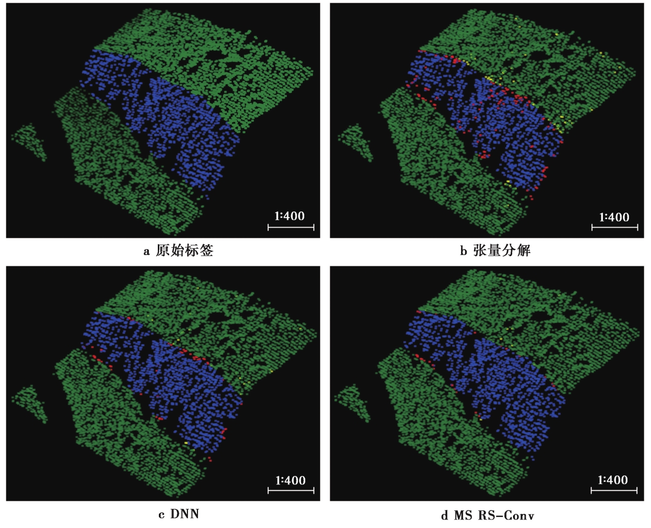
Fig. 9 The results of three fracture zone extraction methods on Samp51.
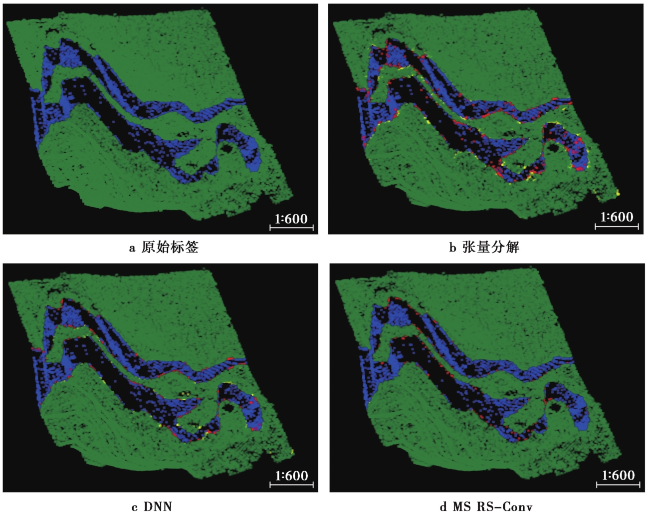
Fig. 10 The results of three fracture zone extraction methods on Samp53.
| 数据集 | 方法 | Ⅰ类误差/% | Ⅱ类误差/% | 总误差/% | 提取精度/% |
|---|---|---|---|---|---|
| CD_1 | 张量分解 | 1.15 | 1.47 | 1.32 | 98.68 |
| DNN | 0.77 | 0.97 | 0.88 | 99.12 | |
| MS RS-Conv | 0.29 | 0.50 | 0.41 | 99.59 | |
| CD_2 | 张量分解 | 1.39 | 1.31 | 1.36 | 98.64 |
| DNN | 0.63 | 2.01 | 1.28 | 98.72 | |
| MS RS-Conv | 0.21 | 0.52 | 0.36 | 99.64 |
Table4 Performance comparison of three fracture zone extraction methods on Chuandian dataset
| 数据集 | 方法 | Ⅰ类误差/% | Ⅱ类误差/% | 总误差/% | 提取精度/% |
|---|---|---|---|---|---|
| CD_1 | 张量分解 | 1.15 | 1.47 | 1.32 | 98.68 |
| DNN | 0.77 | 0.97 | 0.88 | 99.12 | |
| MS RS-Conv | 0.29 | 0.50 | 0.41 | 99.59 | |
| CD_2 | 张量分解 | 1.39 | 1.31 | 1.36 | 98.64 |
| DNN | 0.63 | 2.01 | 1.28 | 98.72 | |
| MS RS-Conv | 0.21 | 0.52 | 0.36 | 99.64 |
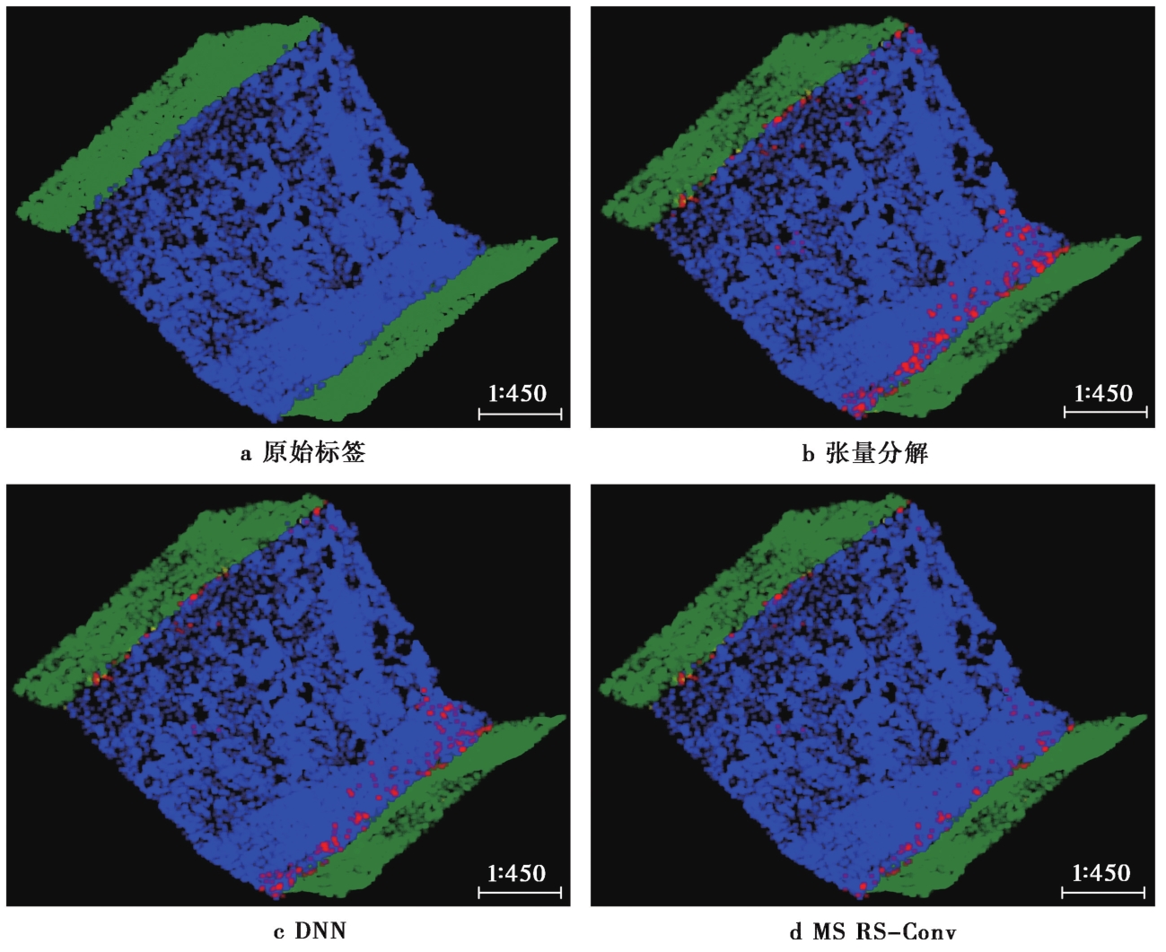
Fig. 11 The results of three fracture zone extraction methods on CD_1.
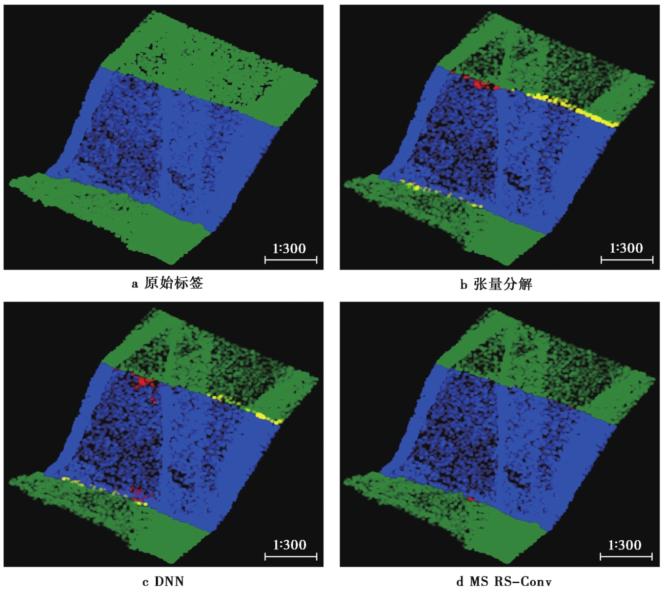
Fig. 12 The results of three fracture zone extraction methods on CD_2.
| 数据集 | 方法 | Ⅰ类误差/% | Ⅱ类误差/% | 总误差/% | 提取精度/% |
|---|---|---|---|---|---|
| 鲜水河点云断裂带 | 张量分解 | 7.74 | 1.07 | 2.13 | 97.87 |
| DNN | 5.11 | 0.91 | 1.58 | 98.42 | |
| MS RS-Conv | 1.19 | 0.13 | 0.30 | 99.70 |
Table5 Performance comparison of three fracture zone extraction methods on Xianshuihe dataset
| 数据集 | 方法 | Ⅰ类误差/% | Ⅱ类误差/% | 总误差/% | 提取精度/% |
|---|---|---|---|---|---|
| 鲜水河点云断裂带 | 张量分解 | 7.74 | 1.07 | 2.13 | 97.87 |
| DNN | 5.11 | 0.91 | 1.58 | 98.42 | |
| MS RS-Conv | 1.19 | 0.13 | 0.30 | 99.70 |
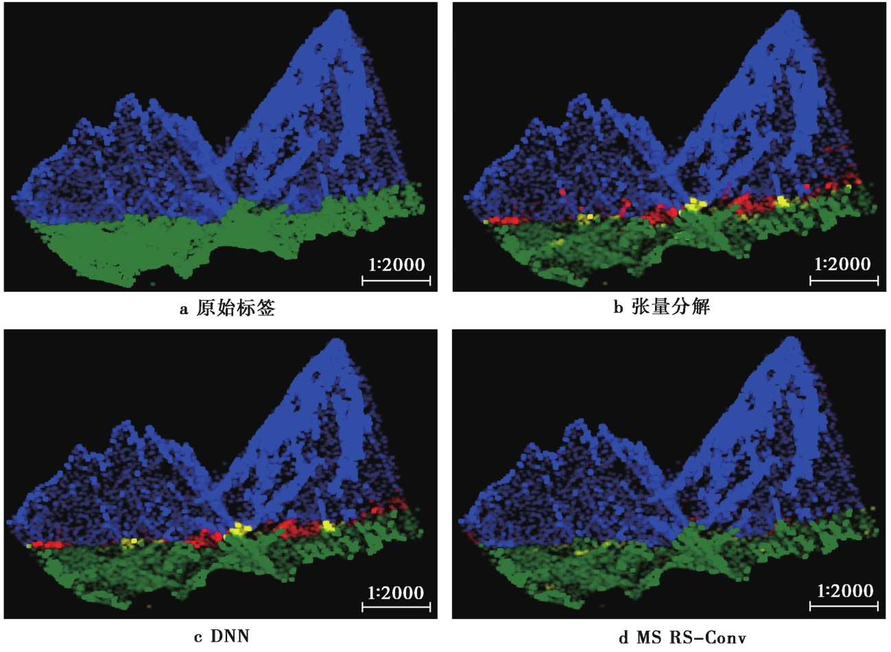
Fig. 13 The results of three fracture zone extraction methods on Xianshuihe fracture zone.
| [1] |
陈梦莹. 2019. 基于高分辨率无人机航测数据对郯庐断裂带沂沭段活动性的研究[D]. 北京: 中国地质大学.
|
|
|
|
| [2] |
高帅坡. 2017. 基于无人机摄影测量技术的活动构造定量参数提取研究[D]. 北京: 中国地震局地质研究所.
|
|
|
|
| [3] |
郭文周, 邓宇, 何庐山, 等. 2017. 航摄与机载激光雷达技术在河道地形测量中的应用[J]. 水资源研究, 6(6): 7.
|
|
|
|
| [4] |
林洪彬, 刘彬, 张玉存. 2012. 基于多尺度张量分解的点云结构特征提取[J]. 中国机械工程, 23(15): 1833—1839.
|
|
|
|
| [5] |
彭检贵, 马洪超, 王宗跃, 等. 2010. 机载LiDAR点云的双阈值自动提取断裂线方法[J]. 测绘科学技术学报, 27(4): 5.
|
|
|
|
| [6] |
席英杰, 李克文, 徐延辉, 等. 2021. 一种用于地震断层图像识别的SPD-UNet模型[J]. 计算机工程, 47(12): 249—255.
|
|
|
|
| [7] |
谢小平, 白毛伟, 陈芝聪, 等. 2019. 龙门山断裂带北东段活动断裂的遥感影像解译及构造活动性分析[J]. 国土资源遥感, 31(1): 237—246.
|
|
|
|
| [8] |
徐景中, 万幼川, 张圣望. 2008. 基于机载激光雷达点云的断裂线自动提取方法[J]. 计算机应用, 28(5): 1214—1216.
|
|
|
|
| [9] |
徐彦怀. 2016. 基于卫星遥感影像和DEM融合的地质断裂带研究[J]. 测绘与空间地理信息, 39(11): 135—138.
|
|
|
|
| [10] |
张志, 张雪亭. 1999. 基于遥感影像信息的东昆仑活动断裂带研究[J]. 西安工程学院学报, 21(3): 5—8.
|
|
|
|
| [11] |
|
| [12] |
|
| [13] |
|
| [14] |
|
| [15] |
|
| [16] |
|
| [17] |
|
| [18] |
|
| [19] |
|
| [20] |
|
| [21] |
|
| [22] |
|
| [23] |
|
| [24] |
|
| [25] |
|
| [26] |
|
| [27] |
|
| [28] |
|
| [29] |
|
| [1] | LIU Xin, WANG Shi-rou, SHI Xu-hua, SU Cheng, LU Chen-yan, QIAN Xiao-yuan, SUN Qiao-yang, DENG Hong-dan, YANG Rong, CHENG Xiao-gan. APPLICATION OF DEEP LEARNING IN ACTIVE TECTONICS AND GEOMORPHOLOGY [J]. SEISMOLOGY AND GEOLOGY, 2024, 46(2): 277-296. |
| [2] | ZHOU Shao-hui, JIANG Hai-kun, LI Jian, QU Jun-hao, ZHENG Chen-chen, LI Ya-jun, ZHANG Zhi-hui, GUO Zong-bin. RESEARCH ON IDENTIFICATION OF SEISMIC EVENTS BASED ON DEEP LEARNING: TAKING THE RECORDS OF SHANDONG SEISMIC NETWORK AS AN EXAMPLE [J]. SEISMOLOGY AND GEOLOGY, 2021, 43(3): 663-676. |
| Viewed | ||||||
|
Full text |
|
|||||
|
Abstract |
|
|||||
