SEISMOLOGY AND GEOLOGY ›› 2024, Vol. 46 ›› Issue (3): 589-607.DOI: 10.3969/j.issn.0253-4967.2024.03.005
Previous Articles Next Articles
CHEN Bai-xu1)( ), YU Zhong-yuan1,2,3),*(), XIAO Peng1), DAI Xun-ye1), ZHANG Shi-long1), ZHENG Rong-ying2)
Received:2023-09-16
Revised:2024-03-03
Online:2024-06-20
Published:2024-07-19
陈柏旭1)(), 余中元1,2,3),*(), 肖鹏1), 戴训也1), 张世龙1), 郑荣荧2)
通讯作者:
*余中元, 男, 教授, 主要从事地震地质方面的研究, E-mail: yuyangzi9811@126.com。
作者简介:陈柏旭, 男, 1998年生, 现为防灾科技学院资源与环境专业在读硕士研究生, 主要从事活动构造方面的研究工作, E-mail: chenbaixufz@163.com。
基金资助:CHEN Bai-xu, YU Zhong-yuan, XIAO Peng, DAI Xun-ye, ZHANG Shi-long, ZHENG Rong-ying. THE NEW FINDINGS OF SURFACE RUPTURE ZONES AND ITS SEISMOLOGICAL SIGNIFICANCE OF THE EASTERN MARGIN OF YUMUSHAN FAULT, NORTHEASTERN MARGIN OF QINGZANG PLATEAU[J]. SEISMOLOGY AND GEOLOGY, 2024, 46(3): 589-607.
陈柏旭, 余中元, 肖鹏, 戴训也, 张世龙, 郑荣荧. 青藏高原东北缘榆木山东缘断裂地表破裂带的新发现及其地震地质意义[J]. 地震地质, 2024, 46(3): 589-607.
Add to citation manager EndNote|Ris|BibTeX
URL: https://www.dzdz.ac.cn/EN/10.3969/j.issn.0253-4967.2024.03.005
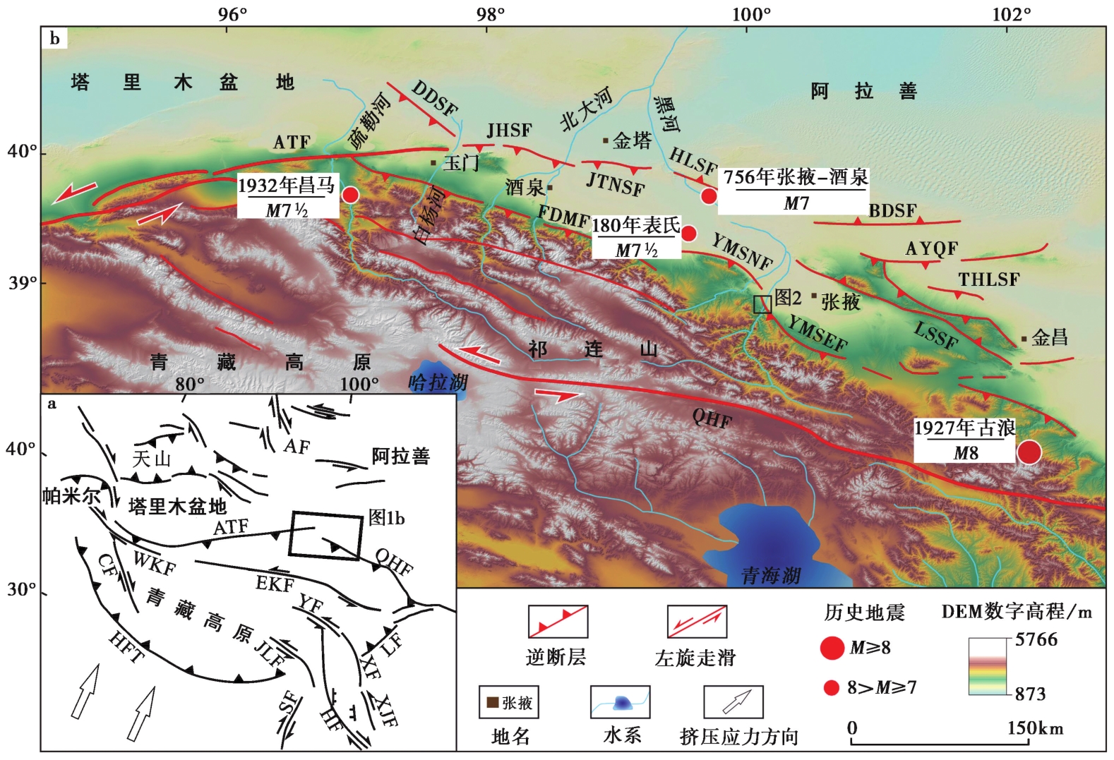
Fig. 1 Tectonic framework of the Hexi Corridor-Qilian Shan.
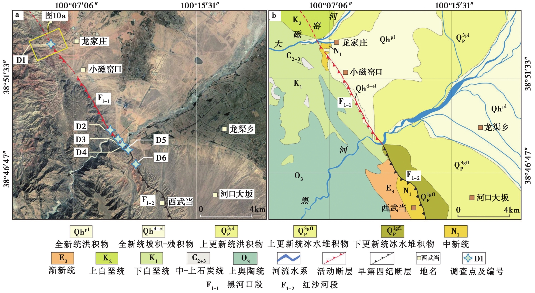
Fig. 2 Remote sensing image and geological map of the study area.

Fig. 3 Fault scarp around Daciyao River at D1 observation point.

Fig. 4 Photo and sketch map of the trench at D1 observation point.
| 地层单元编号 | 地层特征描述 |
|---|---|
| U1 | 土黄色含砾腐殖层。厚约10cm,断层陡坎处尖灭,夹青褐色砾石,砾石直径3~8cm,局部最大可达30cm,磨圆较好,多为圆状、次圆状。 |
| U2 | 灰白色含细砂砾石层。厚约1.4m,向两侧尖灭,偶见草根,砾石多为棱角状和次棱角状,粒径7~15cm。顶部砾石较大,局部可达40cm。底部为砾石夹漫洪相灰黄色含黏土细砂,发育的层理受断层的牵引作用向SW倾斜。 |
| U3 | 冲洪积相浅灰色含细砂砾石层。砾石的粒径普遍较大,较大的为30~60cm,部分砾石的粒径为5~20cm,多为次圆状和次棱角状,无分选。其间夹漫洪相黄灰色细砂,砾石与砂土混杂堆积,未发育层理。 |
| U4 | 灰黄色黄土,厚约0.8m,向NE延伸至断层F3处尖灭,底部被F3断错。 |
| U5 | 灰白色含细砂砾石层。厚约0.6m,砾石粒径多为5~20cm,局部可达40cm,多为次棱角状,与少量细砂混杂堆积。向NE延伸并被F3错断。 |
| U6 | 灰黄色黄土,厚约1m,向SW逐渐减薄,向NE延伸并被F3错断,为充填楔W2的形成提供空间。 |
| U7 | 灰黄色含砂砾石层。厚约3m,砾石粒径多为5~20cm,局部可达0.5m,磨圆一般,多为次圆状和次棱角状,其间夹深黄色细砂层,发育水平层理。被F3错断。 |
| U8 | 灰黄色砾石层。厚约1.2m,相较于上覆的U3层, U8层砾石普遍较小,多为2~5cm,局部可达10cm,多为次棱角状,位于底部的砾石长轴方向沿断层呈顺时针定向偏转。U8层与下伏U9层呈沉积接触。断层的牵引作用使U8层整体向SW倾斜。 |
| U9 | 土黄色粉砂层。厚约2m,以土黄色粉砂为主,含少量砾石,粒径为3~7cm,磨圆较好,多为圆状和次圆状,与U8层呈断层接触。距地表30cm处取光释光样品ZYFZ-OSL-2,测年结果为(0.6±0.07)ka。 |
| W1 | 充填楔,以黄土为主,偶夹砾石,粒径2~5cm,多为圆状和次圆状,无分选,无层理。 |
| W2 | 充填楔,近断层处的砾石层发生拖曳变形,粒径2~5cm,顶部砾石层近水平排列,粒径15~25cm。 |
Table1 Description of characteristics of stratum in the T1 terrace fault profile at D1 obversation point
| 地层单元编号 | 地层特征描述 |
|---|---|
| U1 | 土黄色含砾腐殖层。厚约10cm,断层陡坎处尖灭,夹青褐色砾石,砾石直径3~8cm,局部最大可达30cm,磨圆较好,多为圆状、次圆状。 |
| U2 | 灰白色含细砂砾石层。厚约1.4m,向两侧尖灭,偶见草根,砾石多为棱角状和次棱角状,粒径7~15cm。顶部砾石较大,局部可达40cm。底部为砾石夹漫洪相灰黄色含黏土细砂,发育的层理受断层的牵引作用向SW倾斜。 |
| U3 | 冲洪积相浅灰色含细砂砾石层。砾石的粒径普遍较大,较大的为30~60cm,部分砾石的粒径为5~20cm,多为次圆状和次棱角状,无分选。其间夹漫洪相黄灰色细砂,砾石与砂土混杂堆积,未发育层理。 |
| U4 | 灰黄色黄土,厚约0.8m,向NE延伸至断层F3处尖灭,底部被F3断错。 |
| U5 | 灰白色含细砂砾石层。厚约0.6m,砾石粒径多为5~20cm,局部可达40cm,多为次棱角状,与少量细砂混杂堆积。向NE延伸并被F3错断。 |
| U6 | 灰黄色黄土,厚约1m,向SW逐渐减薄,向NE延伸并被F3错断,为充填楔W2的形成提供空间。 |
| U7 | 灰黄色含砂砾石层。厚约3m,砾石粒径多为5~20cm,局部可达0.5m,磨圆一般,多为次圆状和次棱角状,其间夹深黄色细砂层,发育水平层理。被F3错断。 |
| U8 | 灰黄色砾石层。厚约1.2m,相较于上覆的U3层, U8层砾石普遍较小,多为2~5cm,局部可达10cm,多为次棱角状,位于底部的砾石长轴方向沿断层呈顺时针定向偏转。U8层与下伏U9层呈沉积接触。断层的牵引作用使U8层整体向SW倾斜。 |
| U9 | 土黄色粉砂层。厚约2m,以土黄色粉砂为主,含少量砾石,粒径为3~7cm,磨圆较好,多为圆状和次圆状,与U8层呈断层接触。距地表30cm处取光释光样品ZYFZ-OSL-2,测年结果为(0.6±0.07)ka。 |
| W1 | 充填楔,以黄土为主,偶夹砾石,粒径2~5cm,多为圆状和次圆状,无分选,无层理。 |
| W2 | 充填楔,近断层处的砾石层发生拖曳变形,粒径2~5cm,顶部砾石层近水平排列,粒径15~25cm。 |
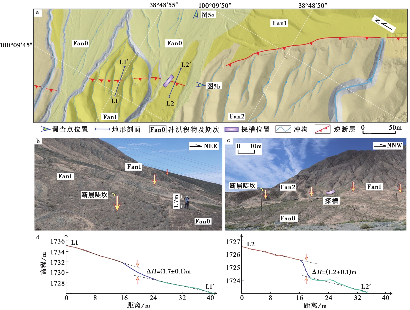
Fig. 5 Position and geomorphic environment of trench at D2 observation point.
| 地层单元编号 | 地层特征描述 |
|---|---|
| U1 | 灰黄色地表粉砂层,厚约20cm,以粉砂为主,夹砾石,偶见植物根系。 |
| U2 | 含砾粉砂层,厚约1m,砾石颜色向SW由土黄色渐变为褐色,分选和磨圆极差。自U2层以下,地层向NE向倾斜,表明断层作用扰动了原始的地层沉积。 |
| U3 | 土黄色粉砂层,夹灰褐色砾石,厚约2.5m,粉砂含量比U2层多,且砾石含量明显高于U3层,含较多碎石,沿SW向可见砾石粒径逐渐变大。沉积厚度稳定,成层性较好,可观察到明显的分层现象,砾石磨圆度中等,分选一般,偶见粒径>5cm的巨砾,为冲洪积相堆积物。 |
| U4 | 青黄色砾石层,厚0.3~0.8m,砾石长轴沿NE向排列,成层性极好,同时具备较好的分选度,但磨圆较差,推测为冲洪积相沉积。 |
| U5 | 浅棕色坡积砾石层,厚0.3~1.1m,成层性较好,分选和磨圆适中,偶见棱角状砾石。 |
| U6 | 黄褐色砾石层,厚约0.7m,相较于U5层,砾石粒径沿长轴方向较长,呈扁平状,分选性沿SW向逐渐变差,未见底。 |
Table2 Description of characteristics of stratum in the trench at D2 observation point
| 地层单元编号 | 地层特征描述 |
|---|---|
| U1 | 灰黄色地表粉砂层,厚约20cm,以粉砂为主,夹砾石,偶见植物根系。 |
| U2 | 含砾粉砂层,厚约1m,砾石颜色向SW由土黄色渐变为褐色,分选和磨圆极差。自U2层以下,地层向NE向倾斜,表明断层作用扰动了原始的地层沉积。 |
| U3 | 土黄色粉砂层,夹灰褐色砾石,厚约2.5m,粉砂含量比U2层多,且砾石含量明显高于U3层,含较多碎石,沿SW向可见砾石粒径逐渐变大。沉积厚度稳定,成层性较好,可观察到明显的分层现象,砾石磨圆度中等,分选一般,偶见粒径>5cm的巨砾,为冲洪积相堆积物。 |
| U4 | 青黄色砾石层,厚0.3~0.8m,砾石长轴沿NE向排列,成层性极好,同时具备较好的分选度,但磨圆较差,推测为冲洪积相沉积。 |
| U5 | 浅棕色坡积砾石层,厚0.3~1.1m,成层性较好,分选和磨圆适中,偶见棱角状砾石。 |
| U6 | 黄褐色砾石层,厚约0.7m,相较于U5层,砾石粒径沿长轴方向较长,呈扁平状,分选性沿SW向逐渐变差,未见底。 |
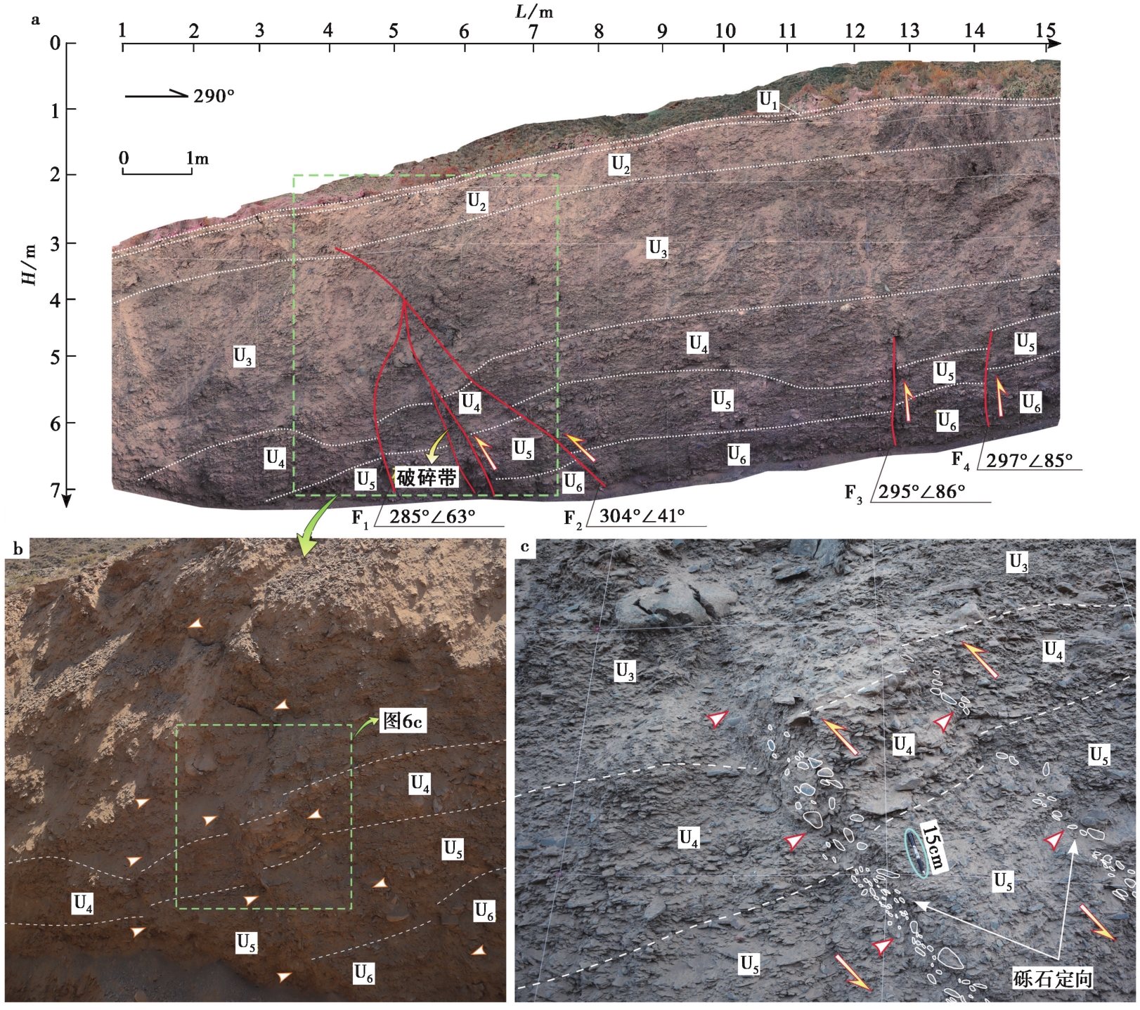
Fig. 6 Photo and sketch map of the west wall of the trench at D2 observation point.

Fig. 7 Profile and geomorphic environment of trench at D3 observation point(adapted from Ren et al., 2019).
| 地层单元编号 | 地层特征描述 |
|---|---|
| U1 | 灰黑色变质安山岩。 |
| U2 | 根据颜色和粒径可细分为U2-1、U2-2、U2-3、U2-4 4个亚层,上覆为棕褐色薄层粉砂,下伏为灰色河床相砾石层,夹杂土黄色粉砂。U2-1—U2-4层粉砂含量依次增多且颜色变浅。 |
| U3 | 灰黄色黄土,在距地表1.3m处取光释光样品ZYFZ-OSL-1,结果为(5.08±0.53)ka。 |
| U4 | 可细分为U4-1、U4-2 2个亚层,上覆为薄层河漫滩相细砂层,下伏为灰色河床相砾石层。 |
| U5 | E1事件相关的崩积楔,顶部可见粉细砂薄层。 |
| U6 | E2事件相关的崩积楔。 |
Table3 Description of characteristics of stratum in the trench at D3 observation point
| 地层单元编号 | 地层特征描述 |
|---|---|
| U1 | 灰黑色变质安山岩。 |
| U2 | 根据颜色和粒径可细分为U2-1、U2-2、U2-3、U2-4 4个亚层,上覆为棕褐色薄层粉砂,下伏为灰色河床相砾石层,夹杂土黄色粉砂。U2-1—U2-4层粉砂含量依次增多且颜色变浅。 |
| U3 | 灰黄色黄土,在距地表1.3m处取光释光样品ZYFZ-OSL-1,结果为(5.08±0.53)ka。 |
| U4 | 可细分为U4-1、U4-2 2个亚层,上覆为薄层河漫滩相细砂层,下伏为灰色河床相砾石层。 |
| U5 | E1事件相关的崩积楔,顶部可见粉细砂薄层。 |
| U6 | E2事件相关的崩积楔。 |
| 地层单元编号 | 地层特征描述 |
|---|---|
| U1 | 表层黄土,厚约0.5m,未被断层断错。断层作用为U1层坎前堆积提供空间,靠近陡坎处堆积较厚,向两侧逐渐变薄。 |
| U2 | 上更新统河流相砾石层,含砂,厚7~10m,夹透镜体,磨圆和分选较好,成层性极好,与上覆表层黄土呈沉积接触,与下伏新近系砂岩呈角度不整合接触,与奥陶系变质安山岩呈断层接触。 |
| U3 | 松散堆积物,表现为以碎石为主的坡积物,多呈扇形。 |
| U4 | 新近系砖红色砂岩,夹橘红色细砂和黄褐色砂砾。 |
| U5 | 奥陶系灰黄色变质安山岩,与断层下盘的上更新统砾石层、新近系砂岩呈断层接触。 |
| U6 | 碎裂岩,为奥陶系变质安山岩,与新近系砖红色砂岩呈断层接触,与上覆上更新统洪积砂砾石层呈角度不整合接触。 |
Table4 Description of characteristics of stratum in the fault profile at D4 observation point
| 地层单元编号 | 地层特征描述 |
|---|---|
| U1 | 表层黄土,厚约0.5m,未被断层断错。断层作用为U1层坎前堆积提供空间,靠近陡坎处堆积较厚,向两侧逐渐变薄。 |
| U2 | 上更新统河流相砾石层,含砂,厚7~10m,夹透镜体,磨圆和分选较好,成层性极好,与上覆表层黄土呈沉积接触,与下伏新近系砂岩呈角度不整合接触,与奥陶系变质安山岩呈断层接触。 |
| U3 | 松散堆积物,表现为以碎石为主的坡积物,多呈扇形。 |
| U4 | 新近系砖红色砂岩,夹橘红色细砂和黄褐色砂砾。 |
| U5 | 奥陶系灰黄色变质安山岩,与断层下盘的上更新统砾石层、新近系砂岩呈断层接触。 |
| U6 | 碎裂岩,为奥陶系变质安山岩,与新近系砖红色砂岩呈断层接触,与上覆上更新统洪积砂砾石层呈角度不整合接触。 |
| 样品编号 | 调查点 | 埋深 /m | U /ug·g-1 | Th /ug·g-1 | K /% | 环境剂量 /Gy·ka-1 | 等效剂量 /Gy | 年龄 /ka |
|---|---|---|---|---|---|---|---|---|
| ZYFZ-OSL-1 | D3 | 1.3 | 3.7±0.37 | 10.4±1.0 | 1.98±0.12 | 3.98±0.1 | 20.25±0.46 | 5.08±0.53 |
| ZYFZ-OSL-2 | D1 | 0.3 | 2.7±0.27 | 11.1±1.1 | 1.79±0.11 | 3.60±0.1 | 2.15±0.11 | 0.6±0.07 |
Table5 OSL dating results of samples
| 样品编号 | 调查点 | 埋深 /m | U /ug·g-1 | Th /ug·g-1 | K /% | 环境剂量 /Gy·ka-1 | 等效剂量 /Gy | 年龄 /ka |
|---|---|---|---|---|---|---|---|---|
| ZYFZ-OSL-1 | D3 | 1.3 | 3.7±0.37 | 10.4±1.0 | 1.98±0.12 | 3.98±0.1 | 20.25±0.46 | 5.08±0.53 |
| ZYFZ-OSL-2 | D1 | 0.3 | 2.7±0.27 | 11.1±1.1 | 1.79±0.11 | 3.60±0.1 | 2.15±0.11 | 0.6±0.07 |
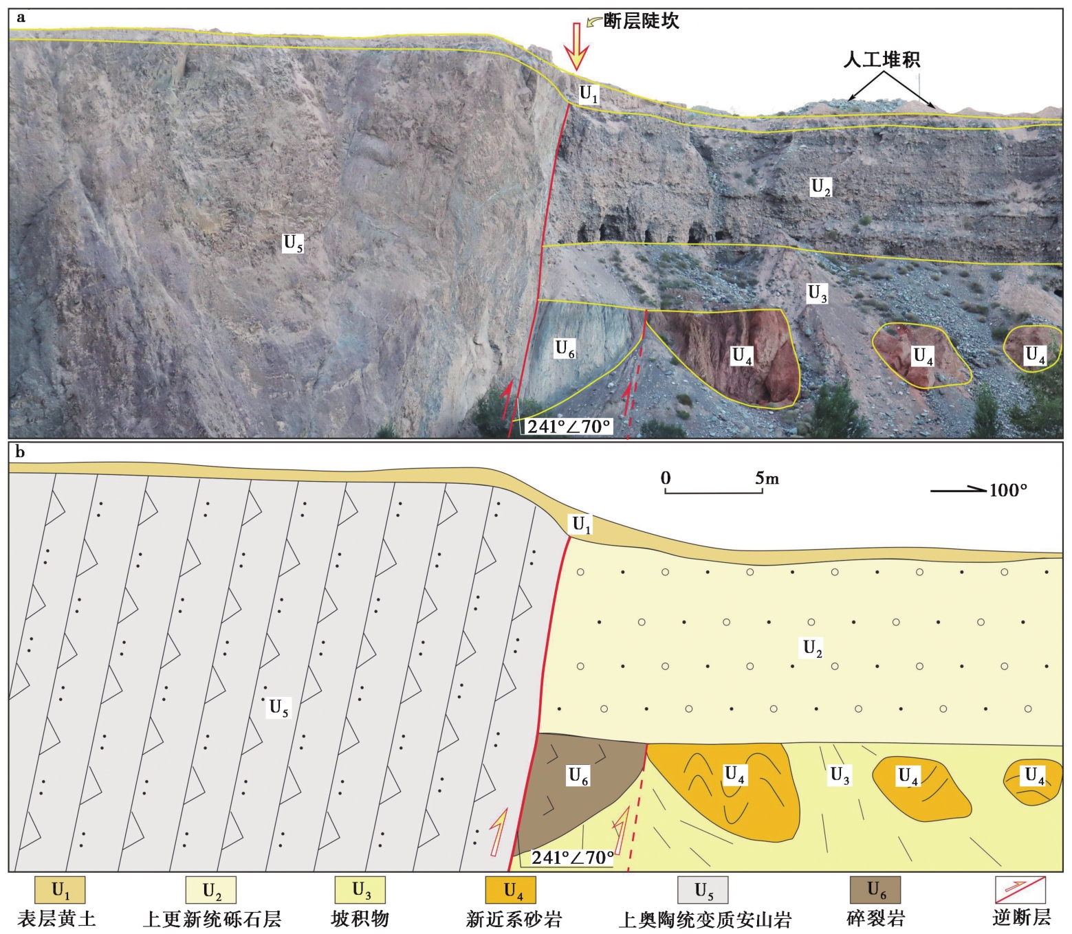
Fig. 8 Fault profile on the north bank of Heihe River at D4 observation point(adapted from Hetzel et al., 2004).

Fig. 9 Typical geological profile at the segment of Hongshahe segment.
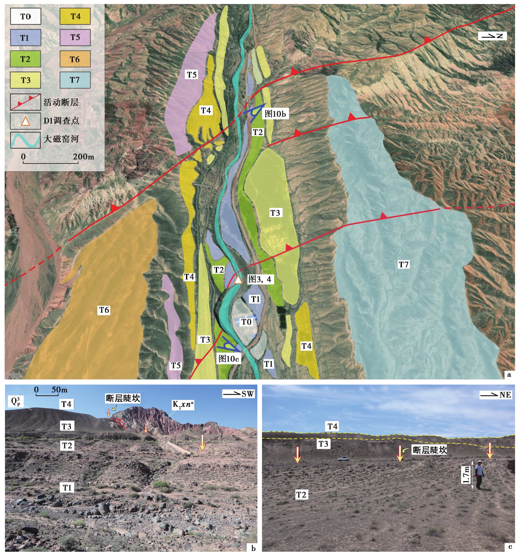
Fig. 10 Interpretation of faulted landform of D1 observation area based on high-resolution remote sensing image.
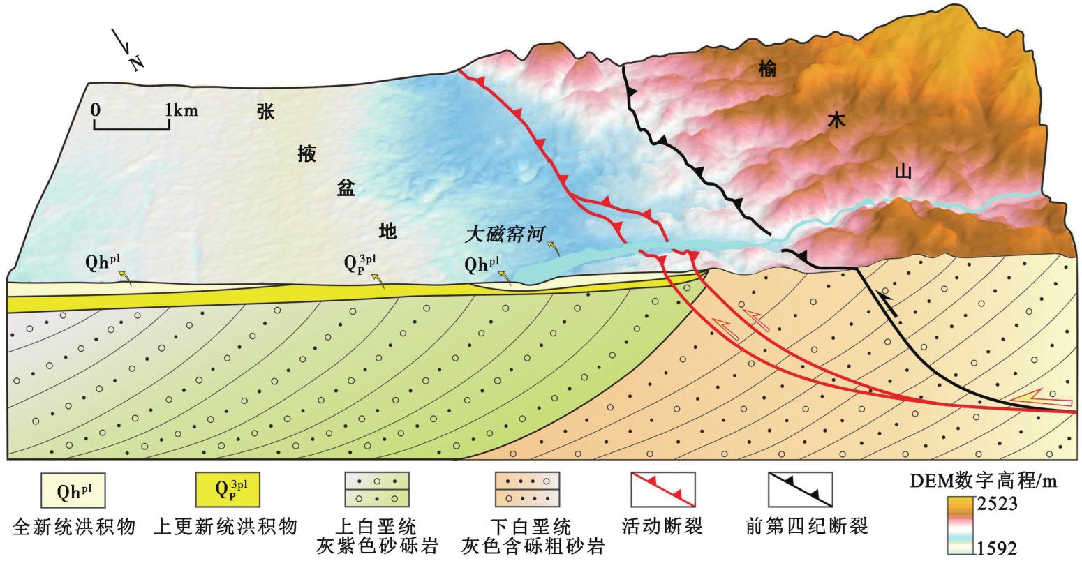
Fig. 11 3D geomorphic model of the eastern margin of the Yumushan Fault.
| [1] |
艾晟, 张波, 樊春, 等. 2017. 武威盆地南缘断裂晚第四纪活动地表形迹与活动速率[J]. 地震地质, 39(2): 408—422. doi: 10.3969/j.issn.0253-4967.2017.02.010.
|
|
|
|
| [2] |
邓起东, 于贵华, 叶文华, 1992. 地震地表破裂参数与震级关系的研究 [G]∥国家地震局地质研究所, 活动断裂研究(2). 北京: 地震出版社: 247—264.
|
|
|
|
| [3] |
国家地震局地质研究所. 1993. 祁连山-河西走廊活动断裂系[M]. 北京: 地震出版社.
|
|
China Earthquake Administration. 1993. Qilian Mountain-Hexi Corridor Active Fault System[M]. Seismological Press, Beijing (in Chinese).
|
|
| [4] |
郭鹏. 2019. 北祁连山冷龙岭断裂大震复发行为与危险性研究[D]. 北京: 中国地震局地质研究所.
|
|
|
|
| [5] |
金卿. 2011. 榆木山断裂带晚第四纪构造活动与大震危险性评价[D]. 兰州: 中国地震局兰州地震研究所.
|
|
|
|
| [6] |
李有利, 李保俊, 杨景春. 1995. 甘肃张掖黑河口断层晚更新世晚期以来的活动[J]. 北京大学学报(自然科学版), 31(3): 351—357.
|
|
|
|
| [7] |
李有利, 杨景春, 李保俊, 等. 1997. 河西走廊榆木山边缘断层构造地貌研究[J]. 地质力学学报, 3(4): 20—26.
|
|
|
|
| [8] |
李玉龙, 邢成起. 1988. 河西走廊地质构造基本特征以及榆木山北麓与黑河口上龙王活断层研究[J]. 西北地震学报, 10(2): 35—47.
|
|
|
|
| [9] |
潘家伟, 李海兵,
|
|
|
|
| [10] |
庞炜. 2015. 祁连山前逆冲断裂带古地震识别的关键技术研究[D]. 兰州: 中国地震局兰州地震研究所.
|
|
|
|
| [11] |
齐若男. 2017. 河西走廊黑河、 梨园河河流阶地对新构造运动的响应[D]. 北京: 中国地质大学.
|
|
|
|
| [12] |
冉勇康, 李志义, 尤惠川, 等. 1988. 河西走廊黑河口断层上的古地震及年代研究[J]. 地震地质, 10(4): 118—126.
|
|
|
|
| [13] |
袁道阳, 张培震, 刘百篪, 等. 2004. 青藏高原东北缘晚第四纪活动构造的几何图像与构造转换[J]. 地质学报, 78(2): 270—278.
|
|
|
|
| [14] |
张宁, 郑文俊, 刘兴旺, 等. 2016. 河西走廊西端黑山断裂运动学特征及其在构造转换中的意义[J]. 地球科学与环境学报, 38(2): 245—257.
|
|
|
|
| [15] |
张培震, 张会平, 郑文俊, 等. 2014. 东亚大陆新生代构造演化[J]. 地震地质, 36(3): 574—585.
|
|
|
|
| [16] |
郑文俊, 张博譞, 袁道阳, 等. 2021. 阿拉善地块南缘构造活动特征与青藏高原东北缘向外扩展的最新边界[J]. 地球科学与环境学报, 43(2): 224—236.
|
|
|
|
| [17] |
|
| [18] |
|
| [19] |
|
| [20] |
|
| [21] |
|
| [1] | LIANG Ming-jian, YANG Yao, DU Fang, GONG Yue, SUN Wei, ZHAO Min, HE Qiang. LATE QUATERNARY ACTIVITY OF THE CENTRAL SEGMENT OF THE DARI FAULT AND RESTUDY OF THE SURFACE RUPTURE ZONE OF THE 1947 M73/4 DARI EARTHQUAKE, QINGHAI PROVINCE [J]. SEISMOLOGY AND GEOLOGY, 2020, 42(3): 703-714. |
| [2] | YU Zhong-yuan, PAN Hua, SHEN Jun, LI Jin-chen, ZHANG Meng, DAI Xun-ye. THE ACTIVITY FEATURES OF XIADIAN FAULT ZONE REVEALED BY RONGJIABAO TRENCH AND ITS PROBABILISTIC SEISMIC HAZARD EVALUATION [J]. SEISMOLOGY AND GEOLOGY, 2020, 42(3): 688-702. |
| Viewed | ||||||
|
Full text |
|
|||||
|
Abstract |
|
|||||
