SEISMOLOGY AND GEOLOGY ›› 2024, Vol. 46 ›› Issue (2): 336-356.DOI: 10.3969/j.issn.0253-4967.2024.02.006
•
XU Yong-qiang1)( ), LEI Jian-she2),*()
Received:2023-12-07
Revised:2024-02-06
Online:2024-04-20
Published:2024-05-29
许永强1)(), 雷建设2),*()
通讯作者:
*雷建设, 男, 1969年生, 博士, 研究员, 主要从事地震波层析成像理论与应用研究, E-mail: 作者简介:许永强, 男, 1998年生, 现为山西大同大学资源与环境专业在读硕士研究生, 主要从事小地震精定位、 震源机制解研究, E-mail: xuyongqiang_sx@163.com。
基金资助:XU Yong-qiang, LEI Jian-she. PRECISE RELOCATION OF SMALL-TO-MODERATE-SIZED EARTHQUAKES IN THE DATONG VOLCANIC GROUP AND SURROUNDING AREAS[J]. SEISMOLOGY AND GEOLOGY, 2024, 46(2): 336-356.
许永强, 雷建设. 大同火山群及邻区中小地震重定位[J]. 地震地质, 2024, 46(2): 336-356.
Add to citation manager EndNote|Ris|BibTeX
URL: https://www.dzdz.ac.cn/EN/10.3969/j.issn.0253-4967.2024.02.006
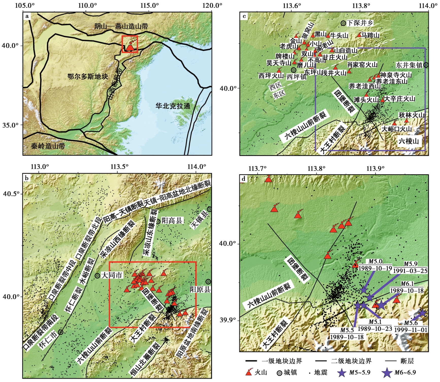
Fig. 1 Distribution of regional tectonics, main faults, and earthquakes.
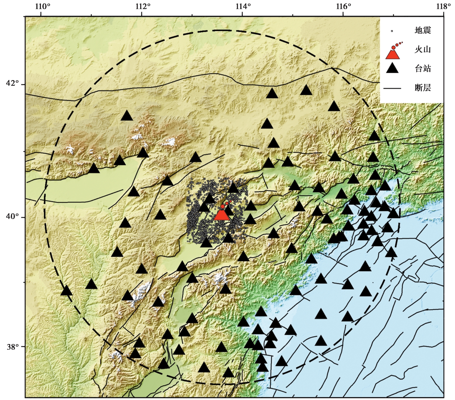
Fig. 2 Distribution of earthquakes and seismic stations used in this study.
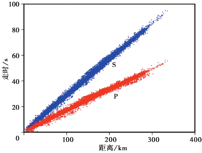
Fig. 3 Observed travel-time curves for the P waves (red dots) and S waves (blue dots).
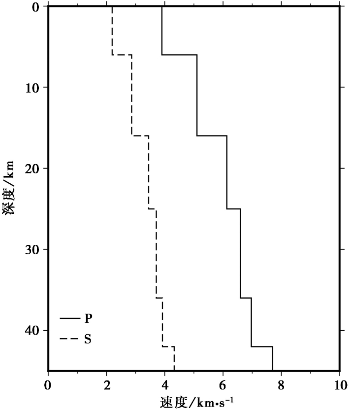
Fig. 4 1D velocity models used in this study.
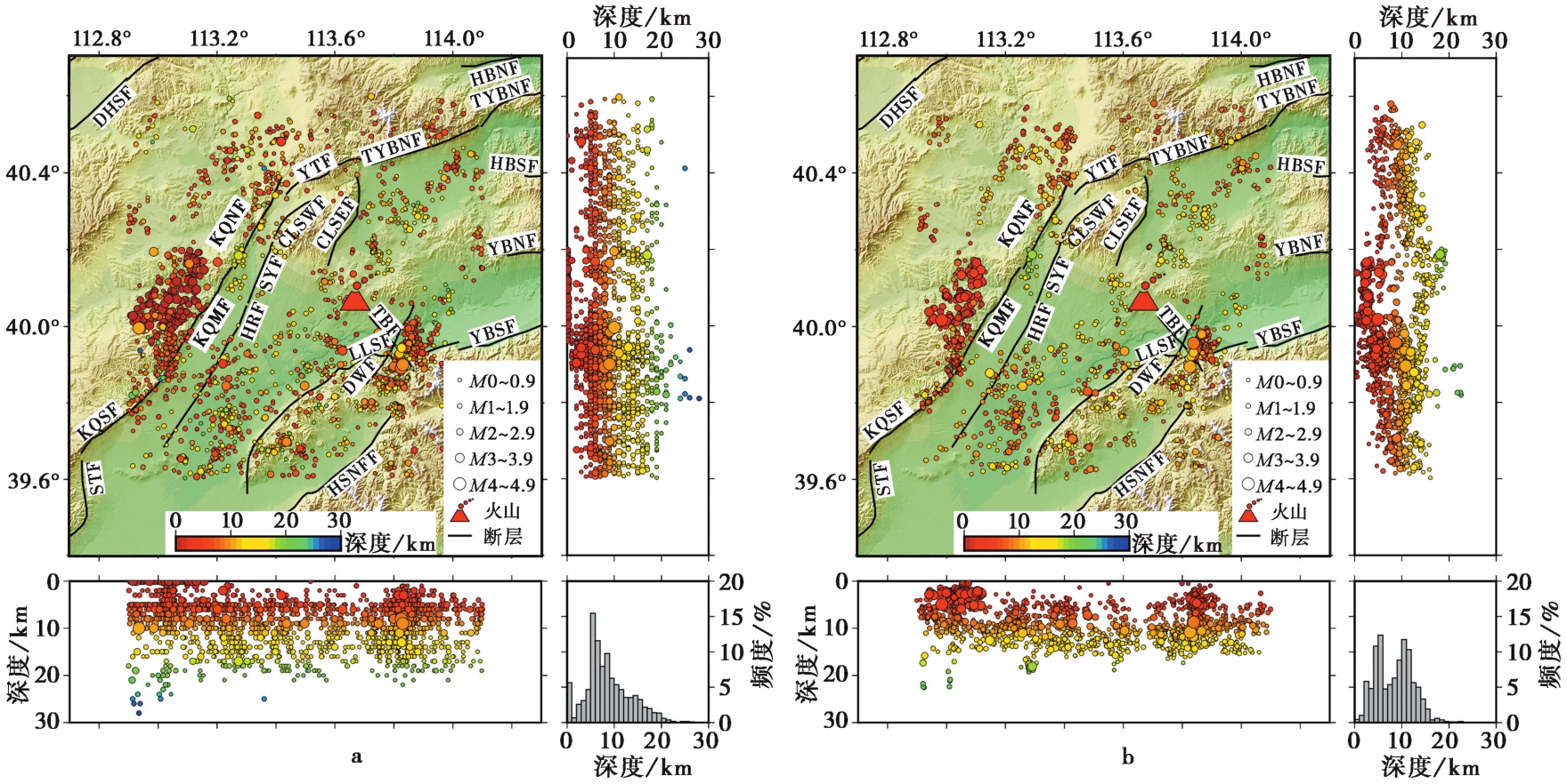
Fig. 5 Comparison between earthquakes before and after relocation.
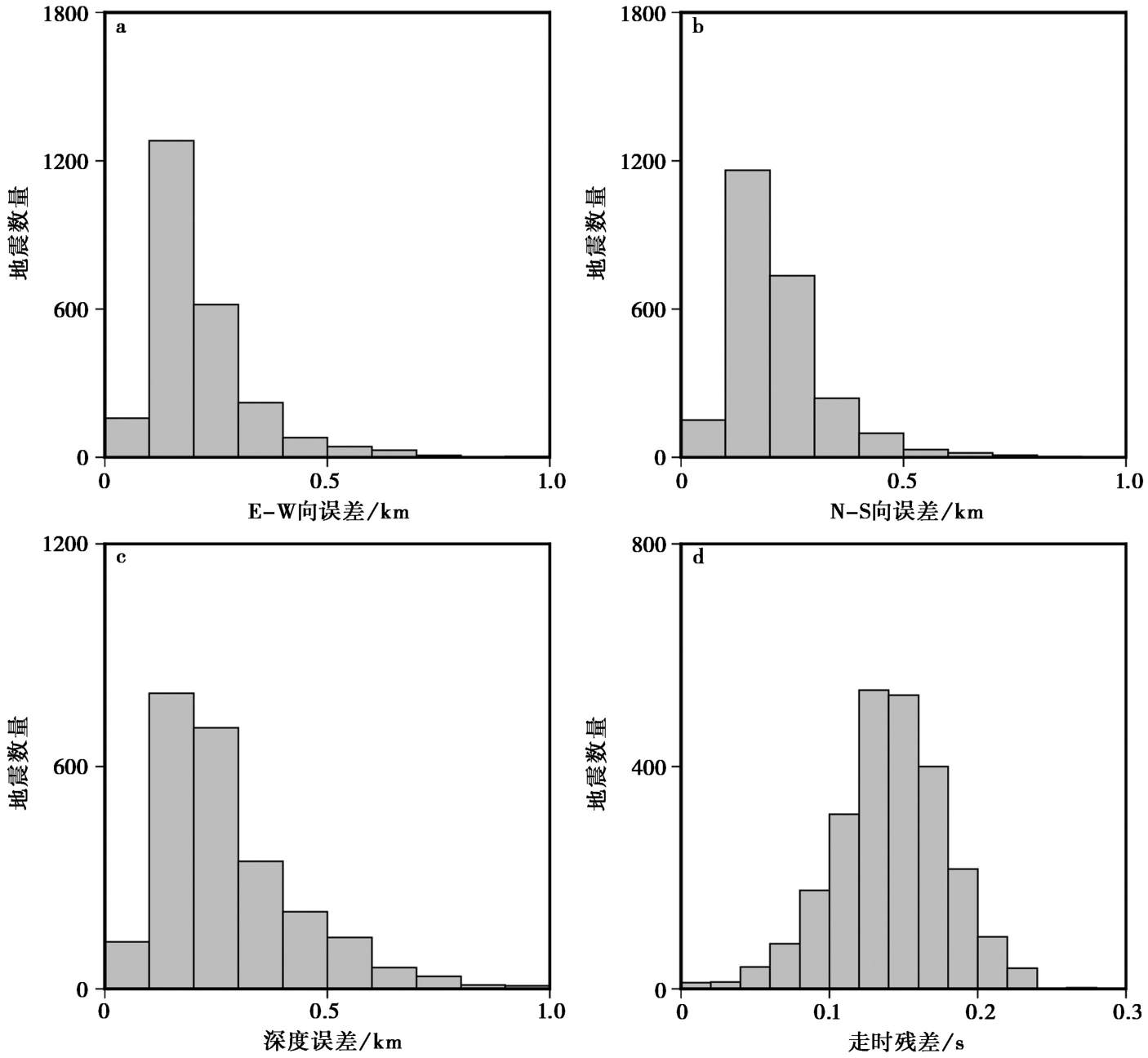
Fig. 6 Relocation errors of earthquakes.
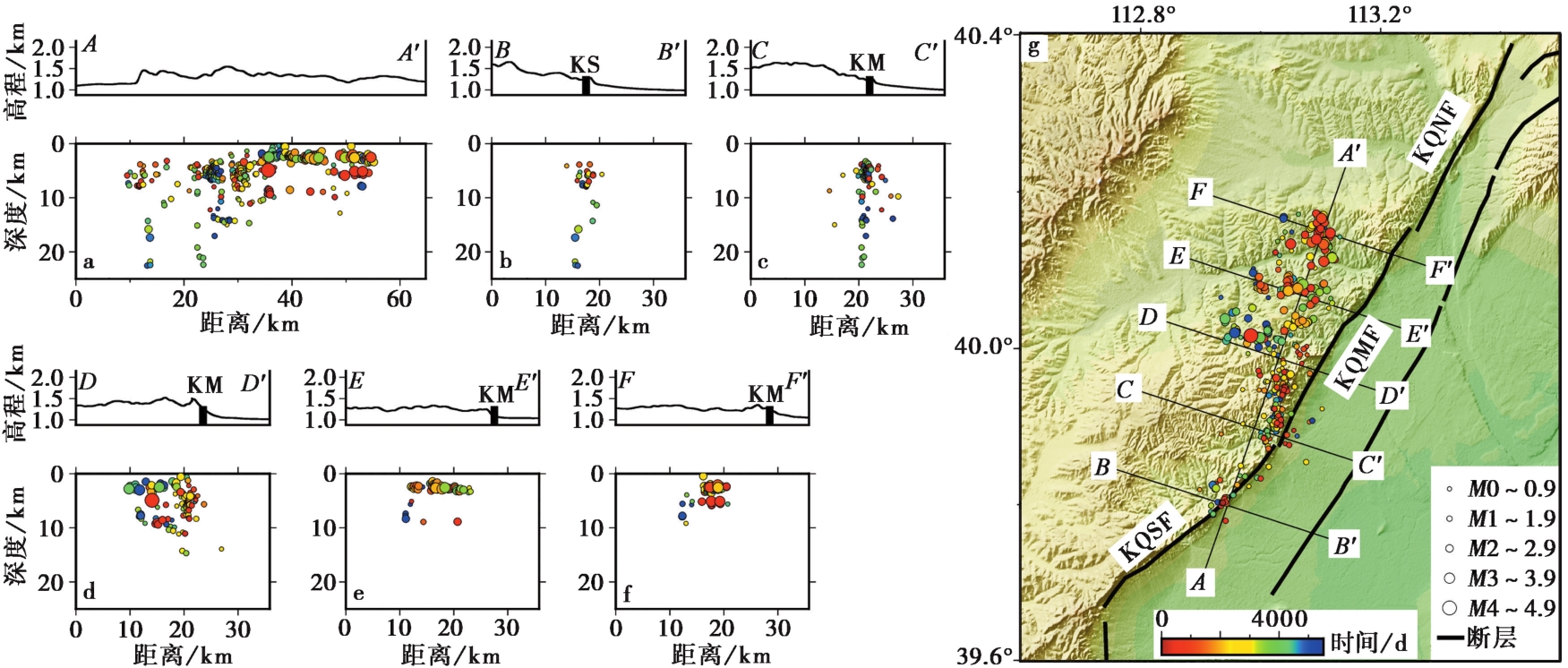
Fig. 7 Distribution of relocated earthquakes around the middle and southern segments of the Kouquan fault zone.
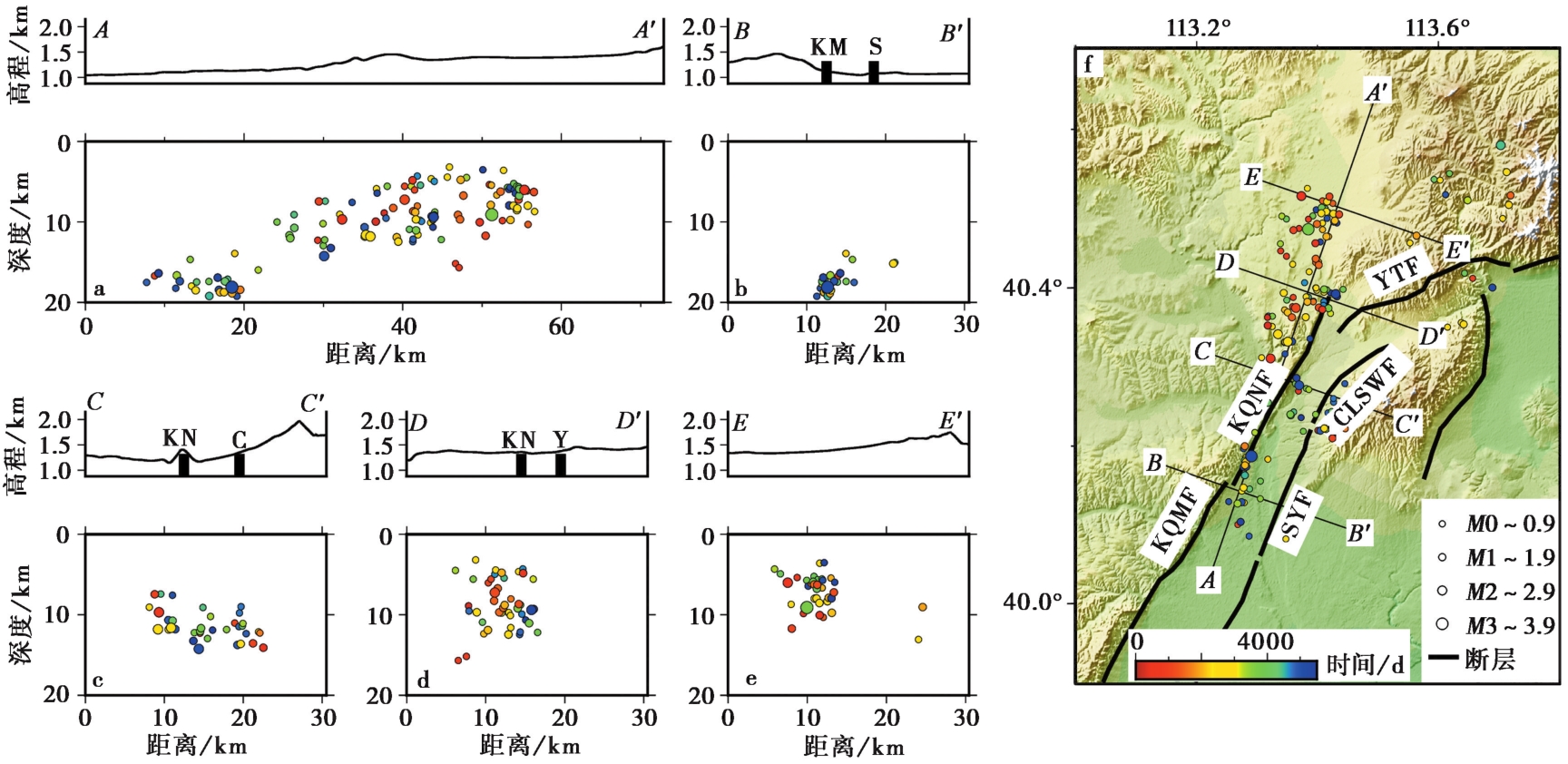
Fig. 8 Distribution of relocated earthquakes around the northern segment of Kouquan fault zone.
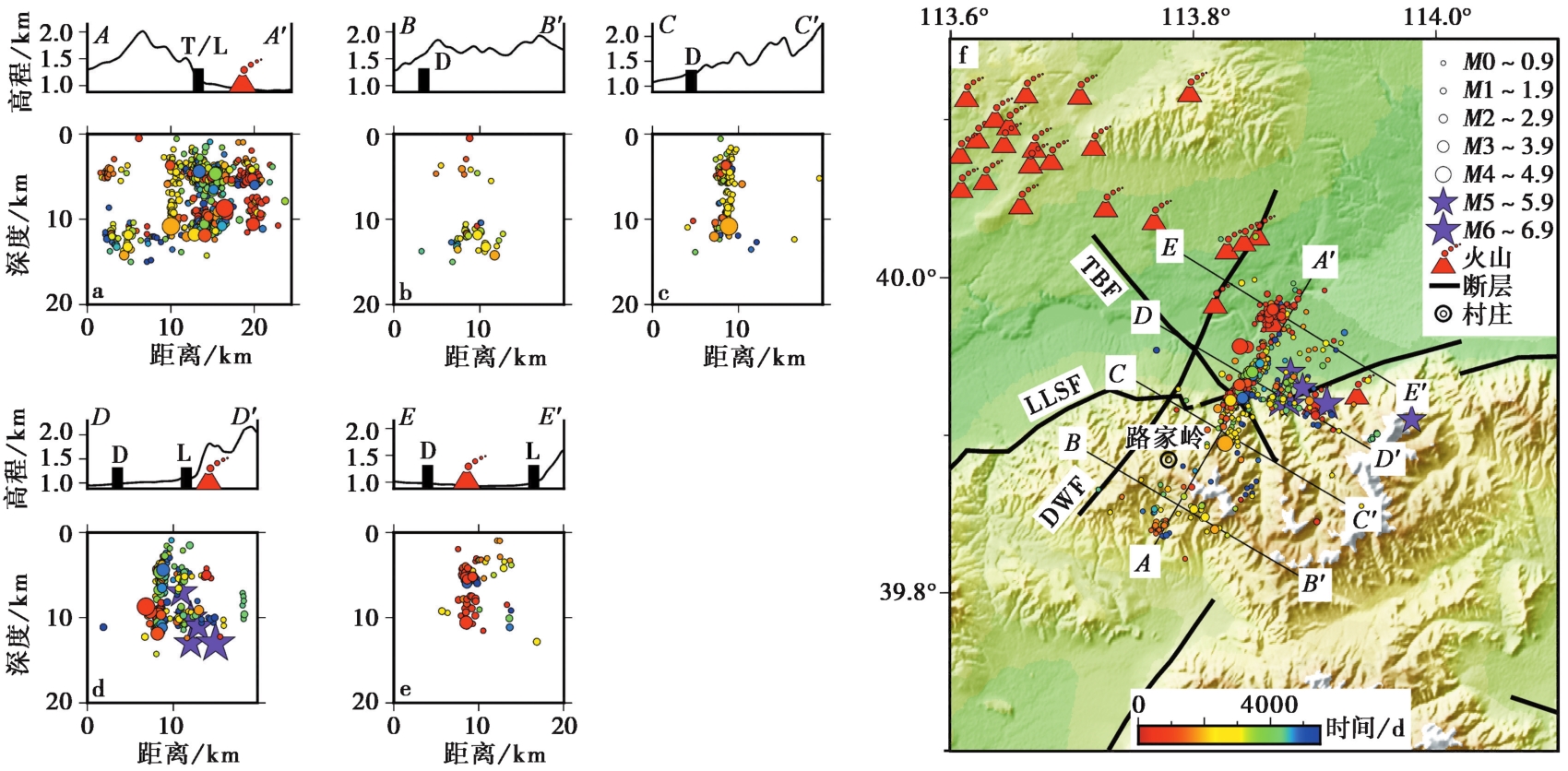
Fig. 9 Distribution of relocated earthquakes around the Datong-Yanggao earthquake area.
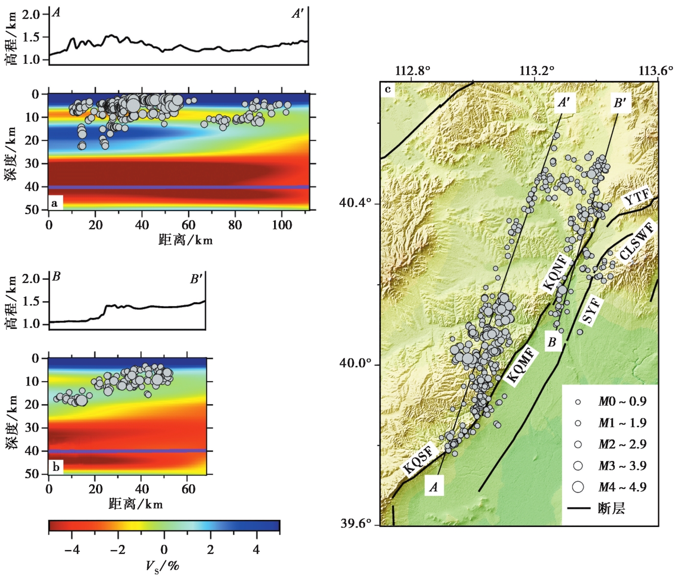
Fig. 10 Relationship between relocated earthquakes and S-wave velocity structure (HOU Jue et al., 2023) along the Kouquan fault zone.
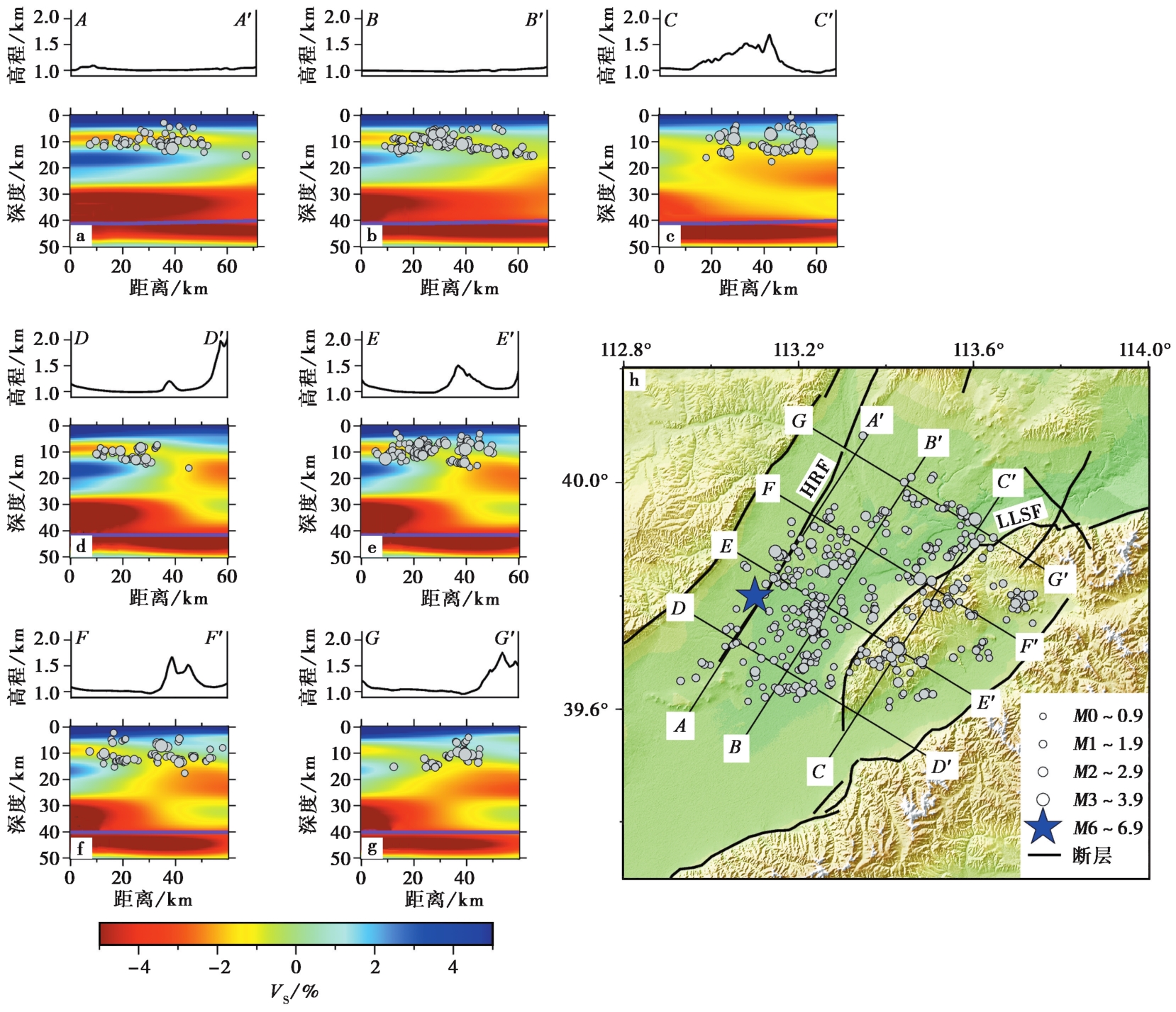
Fig. 11 Relationship between relocated earthquakes and S-wave velocity structure (HOU Jue et al., 2023) in the Datong Basin.
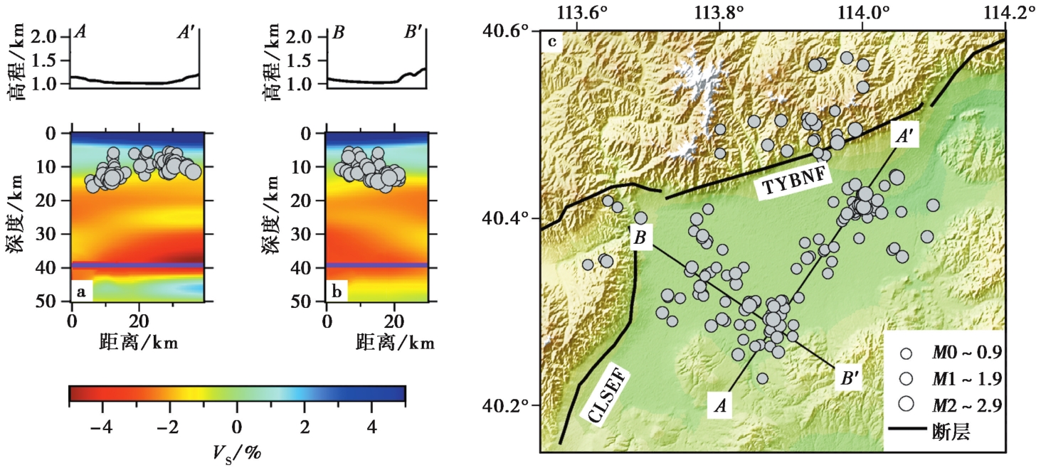
Fig. 12 Relationship between relocated earthquakes and S-wave velocity structure (HOU Jue et al., 2023) in the Yanggao Basin.
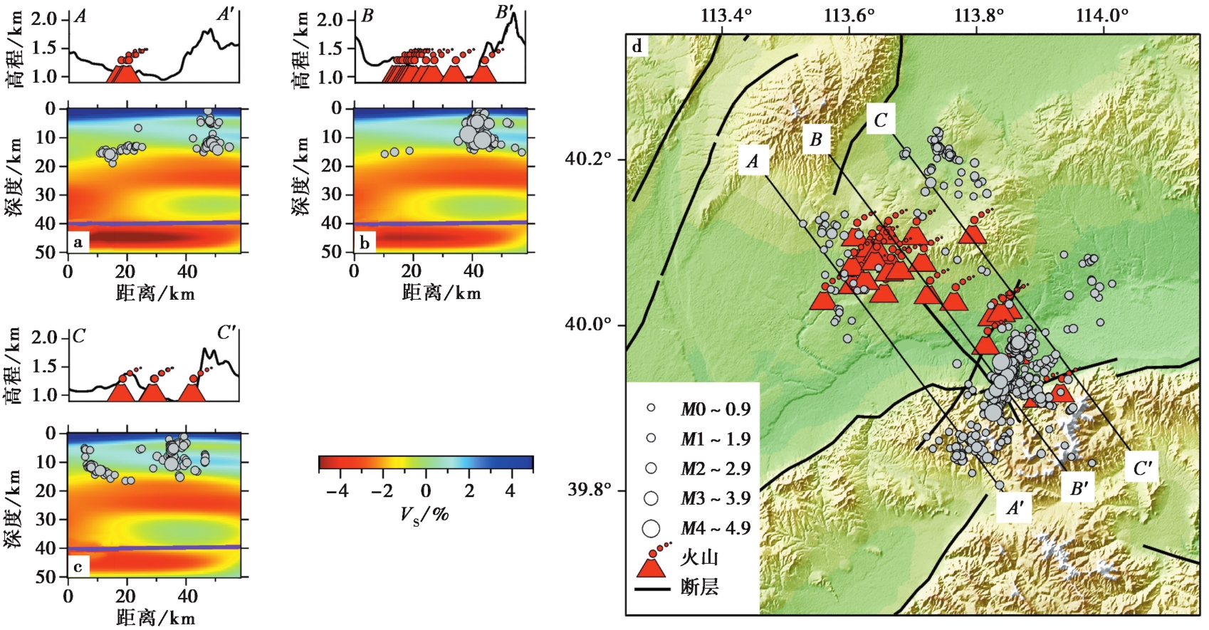
Fig. 13 Relationship between relocated earthquakes and S-wave velocity structure (HOU Jue et al., 2023)around the volcanoes.
| [1] |
安卫平, 苏宗正. 2008. 山西大同火山地貌[J]. 山西地震, 36(1): 3—7.
|
|
|
|
| [2] |
陈成沟, 邢成起, 胡乐银, 等. 2017. 北京及其邻区小震重定位与活动构造分析[J]. 地震, 37(3): 84—94.
|
|
|
|
| [3] |
陈文寄, 李大明, 戴潼谟, 等. 1992. 大同第四纪玄武岩的K-Ar年龄及过剩氩[G]//刘若新. 中国新生代火山岩年代学与地球化学. 北京: 地震出版社: 81—92.
|
|
|
|
| [4] |
陈孝德, 林传勇, 张小鸥, 等. 1997. 山西大同第四纪火山岩中幔源包体的变形特征及其上地幔流变学意义[J]. 地震地质, 19(4): 313—320.
|
|
|
|
| [5] |
冯永革, 王海洋, 陈永顺, 等. 2016. 1989—1999大同地震序列的隐伏断层研究: 库仑应力分析和余震JHD重定位[J]. 地球物理学报, 59(2): 568—577.
DOI |
|
|
|
| [6] |
郭菲. 2021. 大同盆地水峪断裂晚第四纪活动特征研究[D]. 北京: 应急管理部国家自然灾害防治研究院.
|
|
|
|
| [7] |
侯爵, 潘佳铁, 李永华, 等. 2023. 华北克拉通中西部地壳S波速度结构及其地质意义[J]. 地球物理学报, 66(5): 1960—1975.
|
|
|
|
| [8] |
靳玉科, 张青玄, 马金平, 等. 2020. 1989年以来大同-阳高3次5级以上地震序列精定位研究[J]. 山西地震, 48(2): 1—5.
|
|
|
|
| [9] |
李春来, 王培德. 2005. 1999年11月大同地震部分余震的定位及震源机制反演[J]. 地震地磁观测与研究, 26(2): 48—55.
|
|
|
|
| [10] |
李凤英. 2020. 接收函数方法研究大同火山地壳精细结构[D]. 哈尔滨: 哈尔滨工业大学.
|
|
|
|
| [11] |
李虎侯, 孙建中. 1984. 用热释光年龄研究大同火山活动的时代[J]. 中国科学(B辑), 14(7): 637—644.
|
|
|
|
| [12] |
李建华, 宋方敏, 梁小华, 等. 1998. 大同二电厂扩建厂址工程区活动构造评价[J]. 工程地质学报, 6(1): 79—84.
|
|
|
|
| [13] |
李树德. 1988. 中国东部大同火山群发育的构造地貌背景[J]. 地理学报, 43(3): 233—240.
DOI |
|
DOI |
|
| [14] |
李文宣, 吴新国, 冯家麟. 1994. 大同火山群玄武岩研究[J]. 河北地质学院学报, 17(6): 547—555.
|
|
|
|
| [15] |
刘爱荣, 徐永婧, 刘成林, 等. 2021. 大同盆地地质特征及构造演化研究[J]. 现代地质, 35(5): 1296—1310.
|
|
|
|
| [16] |
刘国栋. 1984. 地壳上地幔结构研究的某些新进展(二)[J]. 地震学刊, 4(2): 17—22.
|
|
|
|
| [17] |
罗全星, 李传友, 任光雪, 等. 2020. 阳高-天镇断裂晚第四纪活动特征及滑动速率[J]. 地震地质, 42(2): 399—413.
DOI |
|
DOI |
|
| [18] |
罗全星, 李有利, 胡秀, 等. 2022. 山西地堑系北部六棱山北麓断裂西段晚第四纪右旋走滑速率的约束[J]. 第四纪研究, 42(3): 717—731.
|
|
|
|
| [19] |
罗晓华, 杨明慧, 贾春阳, 等. 2019. 晋北地区口泉断裂带晚中生代分段构造特征[J]. 现代地质, 33(3): 551—560.
|
|
|
|
| [20] |
裴静娴. 1981. 大同地区火山岩流烘烤沉积物的热发光年龄测定[J]. 科学通报, 26(16): 1003—1005.
|
|
|
|
| [21] |
孙若昧, 刘福田. 1995. 京津唐地区地壳结构与强震的发生——I.P波速度结构[J]. 地球物理学报, 38(5): 599—607, 694.
|
|
|
|
| [22] |
王江, 李营, 陈志. 2017. 口泉断裂断层气地球化学变化特征及断层活动性[J]. 地震, 37(1): 39—51.
|
|
|
|
| [23] |
王未来, 吴建平, 房立华, 等. 2012. 2010年玉树 MS7.1 地震及其余震的双差定位研究[J]. 中国科学(地球科学), 42(7): 1037—1046.
|
|
|
|
| [24] |
吴昊昱. 2017. 基于背景噪声成像技术的山西地壳结构及强震孕震环境研究[D]. 太原: 太原理工大学.
|
|
|
|
| [25] |
徐伟, 刘旭东, 张世民. 2011a. 口泉断裂中段晚第四纪以来断错地貌及滑动速率确定[J]. 地震地质, 33(2): 335—346.
|
|
|
|
| [26] |
徐伟, 刘旭东, 张世民. 2011b. 口泉断裂中段晚第四纪最新活动研究[J]. 中国地震, 27(4): 386—395.
|
|
|
|
| [27] |
许云龙. 2015. 大同新生代断陷盆地形成与演化[D]. 太原: 太原理工大学.
|
|
|
|
| [28] |
鄢挺骅. 1994. 山西地震带中段M≥6地震活动特征初探[J]. 山西地震, 22(1): 32—36.
|
|
|
|
| [29] |
尹赞勋. 1976. 大同火山的活动时代[J]. 文物, 27(2): 51—56.
|
|
|
|
| [30] |
袁远, 曹代勇, 林中月, 等. 2011. 大同煤田构造控煤特征研究[J]. 中国煤炭地质, 23(8): 63—65, 77.
|
|
|
|
| [31] |
张成科, 张先康, 盖玉杰, 等. 1998. 大同—阳高震区及其邻区壳幔速度结构与深部构造[J]. 地震地质, 20(4): 391—398.
|
|
|
|
| [32] |
张成科, 张先康, 张建狮. 1999. 大同—阳高震区深部构造背景[J]. 华北地震科学, 17(1): 1—8.
|
|
|
|
| [33] |
张广伟, 雷建设. 2013. 四川芦山7.0级强震及其余震序列重定位[J]. 地球物理学报, 56(5): 1764—1771.
|
|
|
|
| [34] |
张广伟, 雷建设, 谢富仁, 等. 2011. 华北地区小震精定位及构造意义[J]. 地震学报, 33(6): 699—714, 843.
|
|
|
|
| [35] |
张培震, 邓起东, 张国民, 等. 2003. 中国大陆的强震活动与活动地块[J]. 中国科学(D辑), 33(S1): 12—20.
|
|
|
|
| [36] |
张世民, 窦素芹, 杨景春. 1997. 大同第四纪火山群的活动特点[G]//赵国光, 傅子忠, 唐荣余, 等. 地壳构造与地壳应力文集(10). 北京: 地震出版社: 103—111.
|
|
|
|
| [37] |
张学民, 束沛镒, 刁桂苓. 2003. 山西省部分台站下方S波速度结构研究及与地震关系探讨[J]. 地震学报, 25(4): 341—350.
|
|
|
|
| [38] |
钟世军, 王治国, 司政亚, 等. 2022. 北京地区小震精定位结果初步探讨[J]. 中国地震, 38(3): 513—525.
|
|
|
|
| [39] |
|
| [40] |
|
| [41] |
|
| [42] |
|
| [43] |
|
| [44] |
|
| [45] |
|
| [46] |
|
| [47] |
|
| [48] |
|
| [49] |
|
| [50] |
|
| [51] |
|
| [52] |
|
| [53] |
|
| [54] |
|
| [55] |
|
| [56] |
|
| [57] |
|
| [58] |
|
| [59] |
|
| [60] |
|
| [61] |
DOI |
| [62] |
|
| [63] |
|
| [64] |
|
| [65] |
PMID |
| [66] |
|
| [67] |
|
| [68] |
|
| [69] |
|
| [1] | CHEN Han-lin, WANG Qin-cai, ZHANG Jin-chuan, LIU Rui-feng. DISCUSSION ON SEISMOGENIC STRUCTURE OF THE JUNE 2022 MS6.1 EARTHQUAKE AND ITS RELATIONSHIP WITH THE APRIL 2013 MS7.0 EARTHQUAKE IN LUSHAN, SICHUAN PROVINCE [J]. SEISMOLOGY AND GEOLOGY, 2023, 45(5): 1233-1246. |
| [2] | XU Ying-cai, GUO Xiang-yun. RELOCATION OF THE 2022 MS6.0 MAERKANG EARTHQUAKE SWARM IN SICHUAN PROVINCE AND ITS SEISMIC FAULT ANALYSIS [J]. SEISMOLOGY AND GEOLOGY, 2023, 45(4): 1006-1024. |
| [3] | WANG Liang, JIAO Ming-ruo, QIAN Rui, ZHANG Bo, YANG Shi-chao, SHAO Yuan-yuan. CRUSTAL VELOCITY STRUCTURE BENEATH THE SOUTHERN LIAONING PROVINCE DERIVED FROM DOUBLE DIFFERENCE TOMOGRAPHY [J]. SEISMOLOGY AND GEOLOGY, 2022, 44(2): 378-394. |
| [4] | LI Cui-ping, TANG Mao-yun, GUO Wei-ying, WANG Xiao-long, DONG Lei. A PRELIMINARY STUDY ON 3D VELOCITY STRUCTURE OF RONGCHANG AND ITS ADJACENT AREA [J]. SEISMOLOGY AND EGOLOGY, 2022, 44(1): 205-219. |
| [5] | CUI Ren-sheng, ZHAO Cui-ping, ZHOU Lian-qing, CHEN Yang. SEISMICITY FEATURE AND SEISMOGENIC FAULT OF THE MS6.4 EARTHQUAKE SEQUENCE ON JANUARY 19, 2020 IN JIASHI, XINJIANG [J]. SEISMOLOGY AND GEOLOGY, 2021, 43(2): 329-344. |
| [6] | LUO Ren-yu, CHEN Ji-feng, YIN Xin-xin, LI Shao-hua. STUDY ON THE 3D CRUSTAL VELOCITY STRUCTURE OF BODY-WAVE IN GONGHE AREA [J]. SEISMOLOGY AND GEOLOGY, 2021, 43(1): 232-248. |
| [7] | LI Xia, CHEN Shi-jun, ZHANG Zheng-shuai, DAI Zong-hui, LI Xiao-han, LU Zhong-bin. INVERSION OF P-WAVE THREE-DIMENSIONAL VELOCITY STRUCTURE AND ANALYSIS OF SEISMOGENIC STRUCTURE OF EARTHQUAKE SWARM IN 2017 IN MIAODAO ISLANDS, SHANDONG PROVINCE [J]. SEISMOLOGY AND GEOLOGY, 2020, 42(5): 1188-1204. |
| [8] | LI Jun, WANG Qin-cai, CUI Zi-jian, LIU Geng, ZHOU Lin, LU Zhen, ZHOU Hui. FOCAL FAULTS AND STRESS FIELD CHARACTERISTICS OF M7.0 JIUZHAIGOU EARTHQUAKE SEQUENCE IN 2017 [J]. SEISMOLOGY AND GEOLOGY, 2019, 41(1): 58-71. |
| [9] | WANG Zhi-wei, WANG Xiao-long, MA Sheng-li, LEI Xing-lin, LIU Pei-xun. DETAILED TEMPORAL-SPATIAL DISTRIBUTION OF INDUCED EARTHQUAKES BY WATER INJECTION IN RONGCHANG, CHONGQING [J]. SEISMOLOGY AND GEOLOGY, 2018, 40(3): 523-538. |
| [10] | HAN Xiao-ming, Liu Fang, ZHANG Fan, CHEN Li-feng, LI Juan, LI Shuan-hu, YANG Hong-ying. 3D P-WAVE VELOCITY STRUCTURE AT THE NORTHEASTERN MARGIN OF ORDOS BLOCK [J]. SEISMOLOGY AND GEOLOGY, 2018, 40(1): 215-231. |
| [11] | ZHU Ai-lan, XU Xi-wei, REN Ye, SUN Dong-jun, WANG Peng, YU Hai-ying, SONG Xiu-qing, LIU Fang. RELOCATION OF THE BACKGROUND SEISMICITY AND INVESTIGATION ON THE BURIED ACTIVE FAULTS IN SOUTHEASTERN CHINA [J]. SEISMOLOGY AND GEOLOGY, 2017, 39(1): 67-80. |
| [12] | FANG Li-hua, WU Jian-ping, WANG Wei-lai, LÜ|Zuo-yong, WANG Chang-zai, YANG Ting, ZHONG Shi-jun. RELOCATION OF THE AFTERSHOCK SEQUENCE OF THE MS6.5 LUDIAN EARTHQUAKE AND ITS SEISMOGENIC STRUCTURE [J]. SEISMOLOGY AND GEOLOGY, 2014, 36(4): 1173-1185. |
| [13] | HU Nan, HAN Zhu-jun. SEISMOLOGICAL STUDY ON BEHAVIORS OF PRESENT-DAY MOVEMENT OF ARCUATE TECTONIC BELT IN SOUTHEAST YUNNAN [J]. SEISMOLOGY AND GEOLOGY, 2013, 35(1): 1-21. |
| Viewed | ||||||
|
Full text |
|
|||||
|
Abstract |
|
|||||
