地震地质 ›› 2025, Vol. 47 ›› Issue (1): 16-35.DOI: 10.3969/j.issn.0253-4967.2025.01.002

• 西藏日喀则市定日县地震专题论文 • 上一篇    下一篇

2025年1月7日西藏定日MS6.8地震地表破裂解译与建筑物震害损毁统计

邹俊杰1,2)(), 邵志刚1,2),*(), 何宏林3), 高璐4), 许月怡1,2), 窦爱霞1,2), 梁泽毓1,2)   

  1. 1) 中国地震局地震预测研究所, 北京 100036
    2) 地震预测与风险评估应急管理部重点实验室, 北京 100036
    3) 地震动力学与强震预测全国重点实验室(中国地震局地质研究所), 北京 100029
    4) 东北大学, 资源与土木工程学院, 沈阳 100167
  • 收稿日期:2025-01-23 修回日期:2025-01-27 出版日期:2025-02-20 发布日期:2025-02-17
  • 通讯作者: 邵志刚
  • 作者简介:

    邹俊杰, 男, 1991 年生, 副研究员, 主要从事活动构造与地震地质、构造地质学与构造地貌、地震活动性分析与地震中长期预测研究, E-mail:

  • 基金资助:
    中国地震局地震预测研究所基本科研业务专项(CEAIEF20230208); 地震动力学国家重点实验室开放基金(LED2024B03); 国家自然科学基金(42202255); 国家重点研发计划项目(2023YFC3012003); 中国地震局震情跟踪项目(2024020508)

SURFACE RUPTURE INTERPRETATION AND BUILDING DAMAGE ASSESSMENT OF XIZANG DINGRI MS6.8 EARTHQUAKE ON JANUARY 7, 2025

ZOU Jun-jie1,2)(), SHAO Zhi-gang1,2),*(), HE Hong-lin3), GAO Lu4), XU Yue-yi1,2), DOU Ai-xia1,2), LIANG Ze-yu1,2)   

  1. 1) Institute of Earthquake Forecasting, China Earthquake Administration, Beijing 100036, China
    2) Key Laboratory of Earthquake Forecasting and Risk Assessment, Ministry of Emergency Management, Beijing 100036, China
    3) State Key Laboratory of Earthquake Dynamics and Forecasting, Institute of Geology, China Earthquake Administration, Beijing 100029, China
    4) School of Resources and Civil Engineering, Northeastern University, Shenyang 100167, China
  • Received:2025-01-23 Revised:2025-01-27 Online:2025-02-20 Published:2025-02-17
  • Contact: SHAO Zhi-gang

摘要:

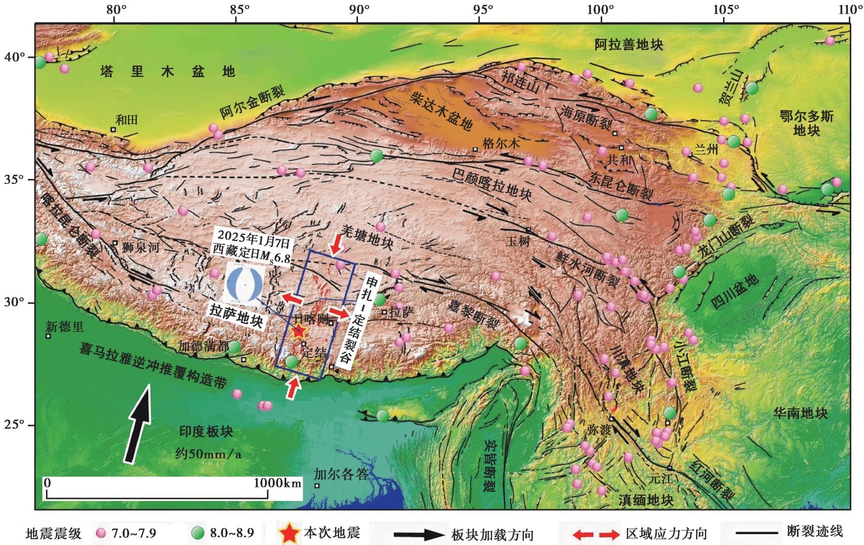
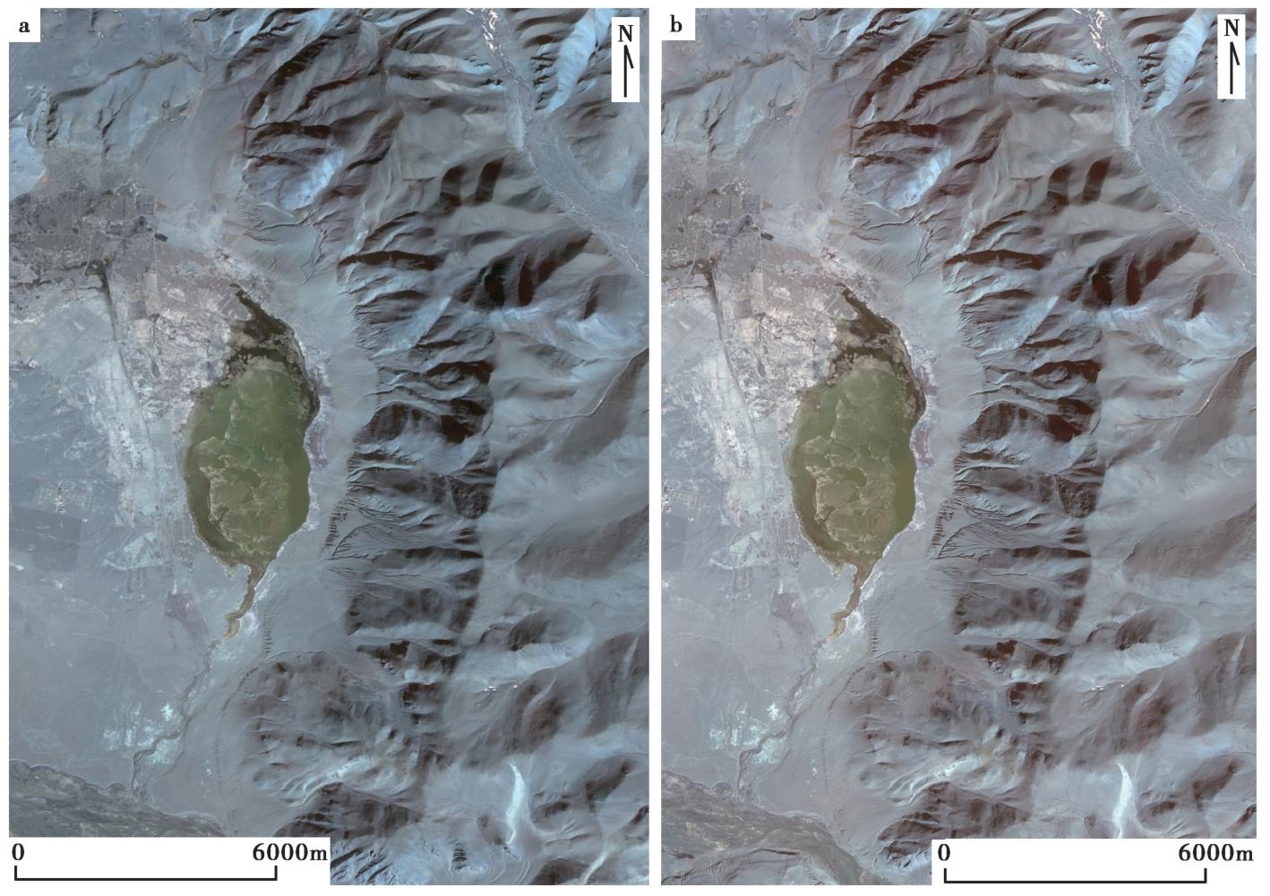
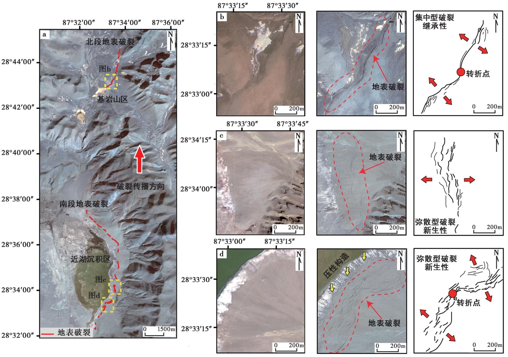
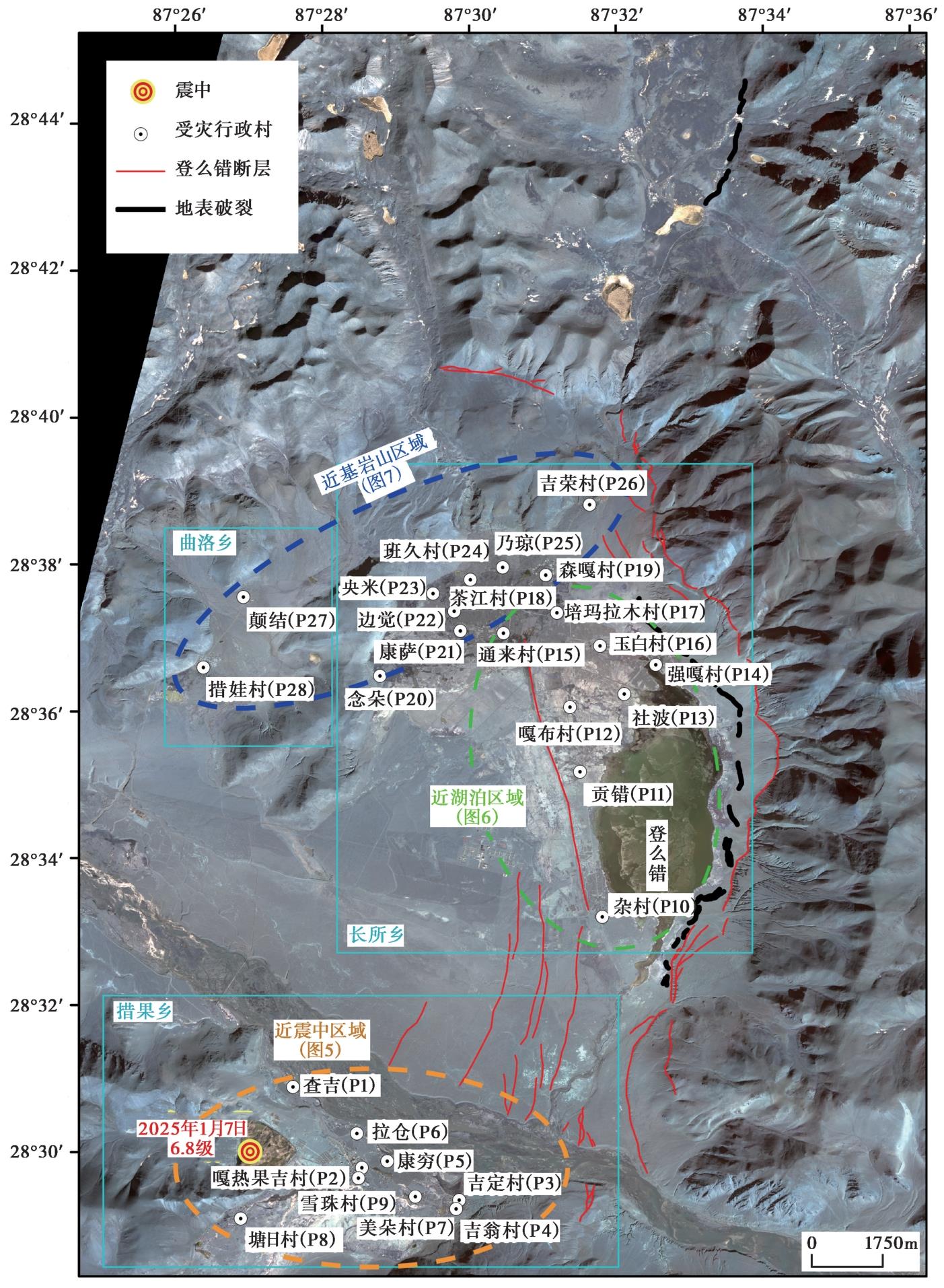
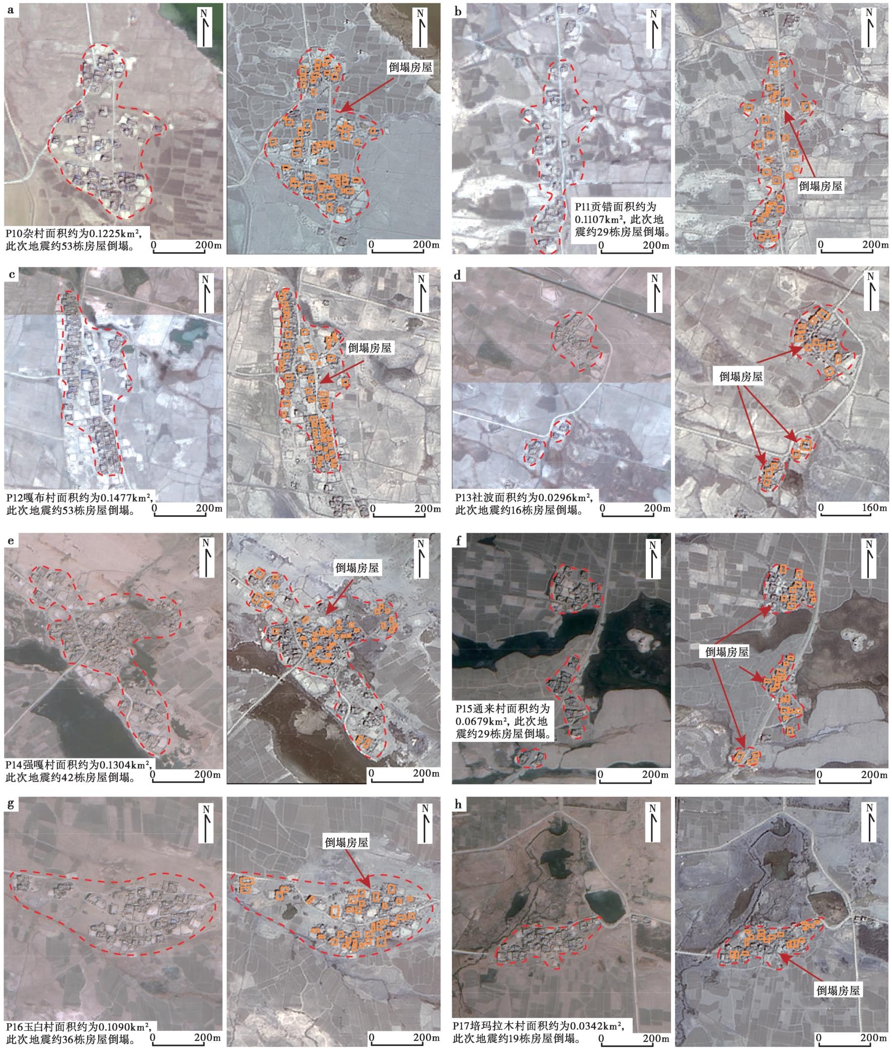
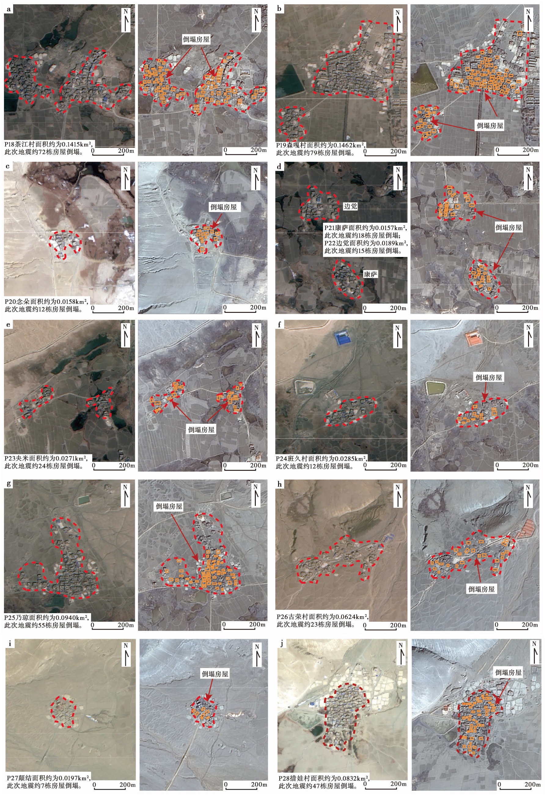
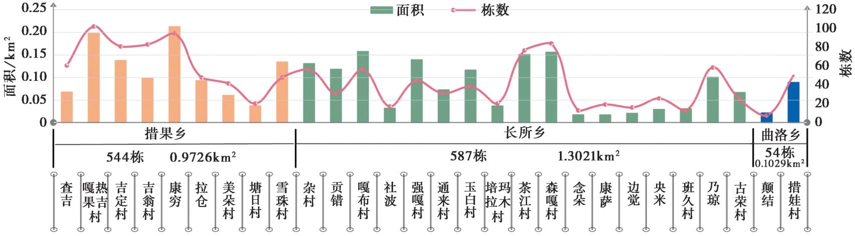
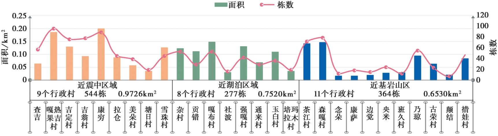
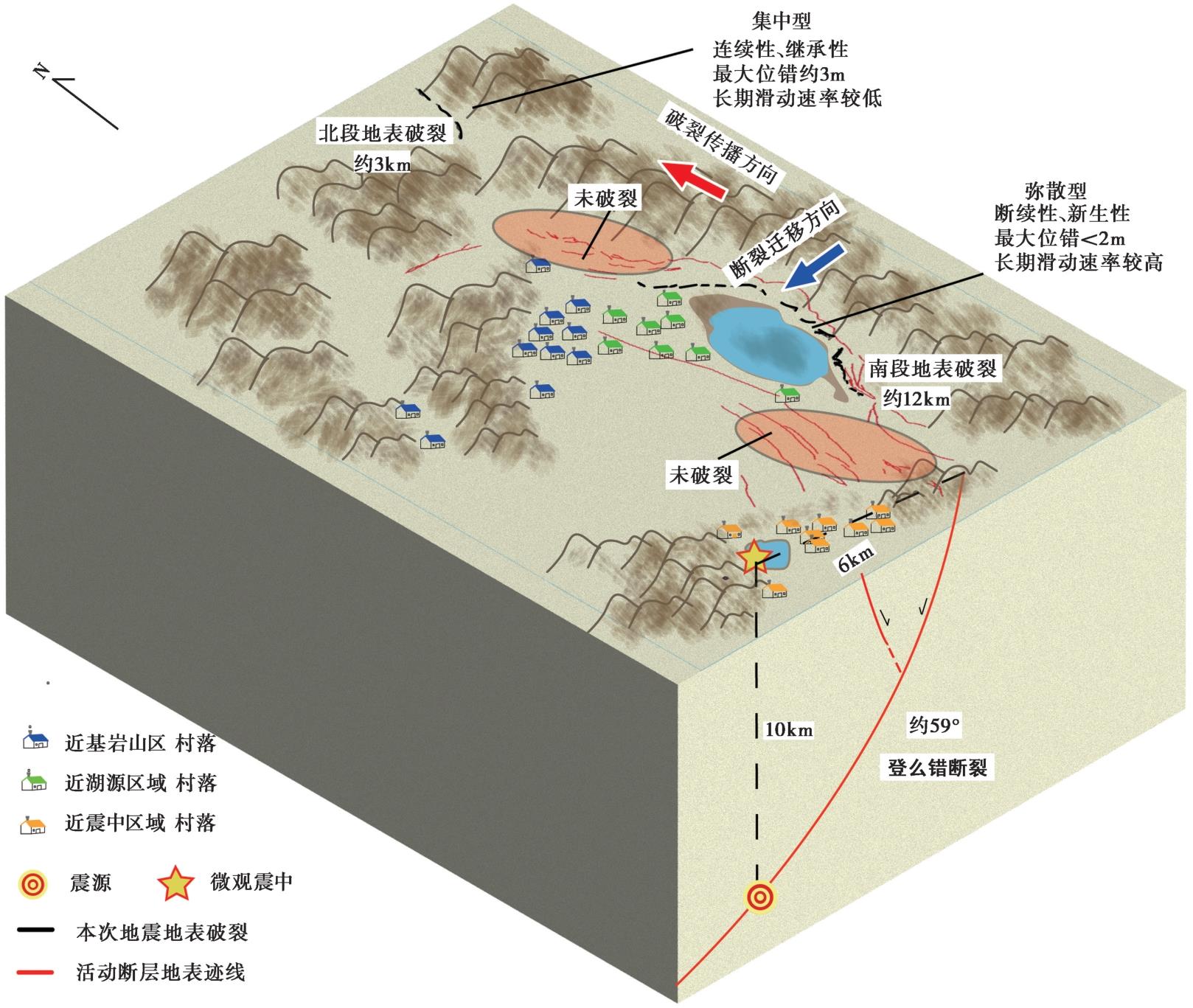
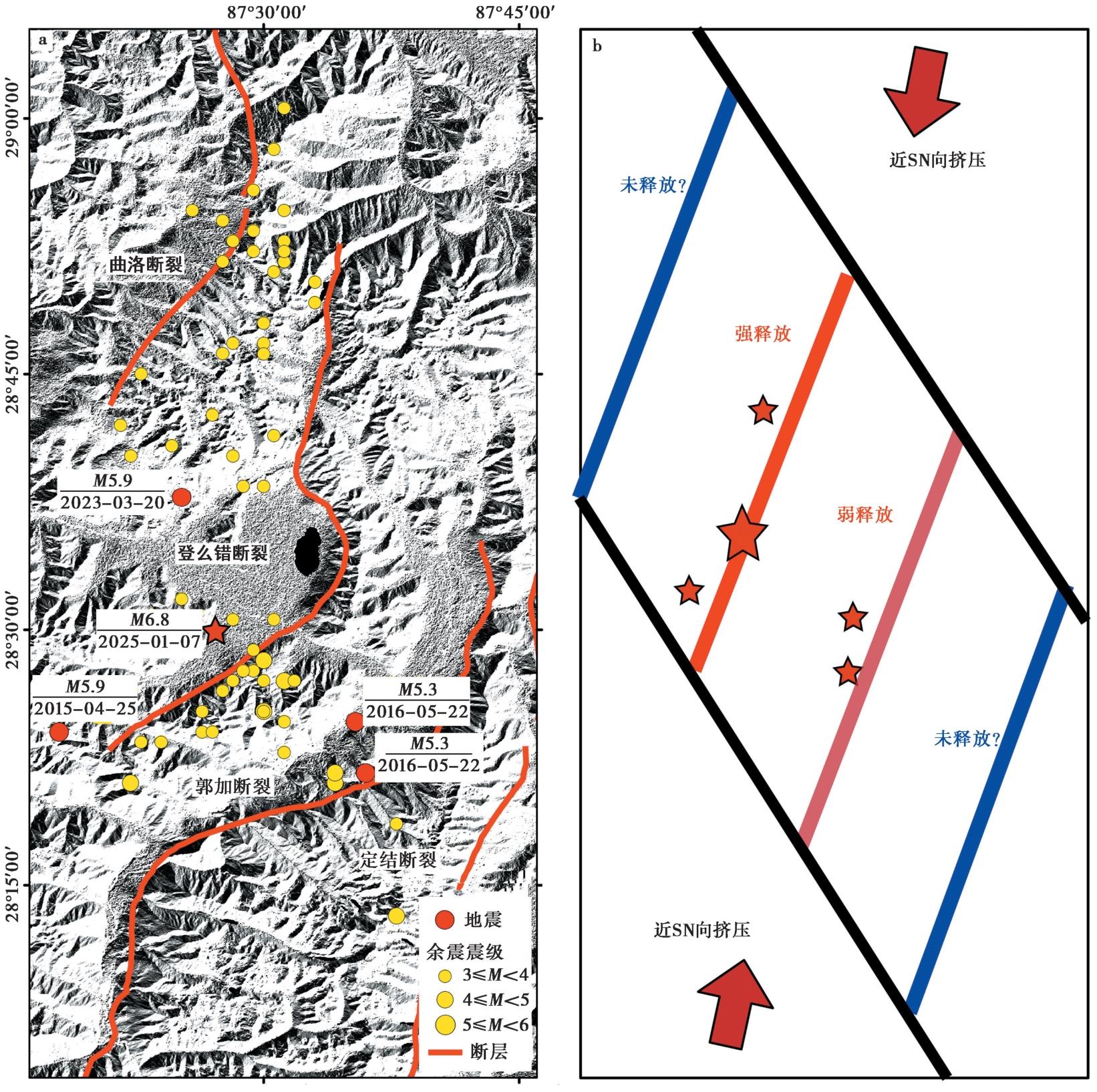
2025年1月7日9时5分, 西藏日喀则市定日县发生6.8级地震, 震源深度10km, 地震最高烈度达Ⅸ度。文中通过高分2号遥感数据开展震前与震后影像解译, 揭示发震断裂登么错断裂的同震地表破裂在几何样式上具有南、北段分异性, 北段长约3km, 表现为几何结构相对简单、破裂宽度较窄的“集中型破裂”样式, 具有连续性和继承性; 南段长约12km, 表现为几何结构较为复杂、破裂宽度较宽的“弥散型破裂”样式, 具有断续性和新生性。震中区附近28个行政村的房屋倒塌数量和面积统计显示, 震中附近3个行政乡的受灾程度由高到低依次为长所乡、措果乡、曲洛乡。将受灾行政村按地质地理环境分区, 受灾面积由大到小依次为近微观震中区、靠近地表破裂带的湖泊区、远离微观震中和地表破裂的近基岩山区。同震地表破裂解译表明, 登么错湖以北和以南存在2个未破裂的断层区段, 结合地震由南向北单侧破裂的过程及震后余震分布的特点, 认为南段未破裂区的地震危险性可能更高。在区域尺度上, 曲洛断裂、登么错断裂、郭加断裂、定结断裂这4条断裂组成的正断层对本次地震均有震后响应, 考虑近期中强地震能量释放的特点, 曲洛断裂和定结断裂的地震危险性值得关注。最后, 依据此次地震特点, 文中提出在高寒高海拔、地质地貌类型多样、断层变形样式弥散、少数民族聚居地区开展震害防御的对策与建议。

关键词: 定日MS6.8地震, 高分遥感影像解译, 地震地表破裂, 建筑物震害损毁统计, 对策与建议

Abstract:

On January 7, 2025, at 9:05 AM, a 6.8-magnitude earthquake struck Dingri County, Shigatse City, Xizang, at a depth of 10km. The maximum intensity of the earthquake reached Ⅺ degrees. This study provides a comparative analysis of pre- and post-earthquake remote sensing images using GF-2 satellite data. The results identify the Dengmecuo fault as the primary seismogenic fault for the earthquake. Surface ruptures exhibit distinct geometric variations between the northern and southern segments. The northern segment, approximately 3km in length, features a relatively simple geometry with a narrow rupture width, forming a “concentrated rupture” pattern characterized by continuity. In contrast, the southern segment, approximately 12km long, displays a more complex geometry with a wider rupture width, resulting in a “diffuse rupture” pattern marked by discontinuities. Statistical analysis of building collapses and damage in 28 administrative villages near the epicenter shows that the severity of impact follows this order: Changcuo township, Cuoguo township, and Quluo township. Affected villages were classified based on their geological and geographical conditions, revealing that the earthquake's impact diminished in the following sequence: areas near the micro-epicenter, lake regions adjacent to the surface rupture zone, and bedrock mountainous areas far from the epicenter and rupture. Coseismic surface rupture analysis reveals two fault segments near Dengmecuo Lake that did not rupture. Considering the unilateral rupture pattern from south to north and the distribution of aftershocks, it is suggested that the unruptured southern segment may pose a greater seismic hazard. At a regional scale, normal faults within the fault system, including the Quluo, Dengmecuo, Guojia, and Dingjie faults, all exhibit aftershock activity. Given the recent release patterns of moderate-to-strong earthquakes, special attention should be given to the seismic risk associated with the Quluo and Dingjie faults. Finally, based on the geographical conditions, seismogenic structures, and seismic damage patterns, this study offers strategies for mitigating seismic risks in high-altitude, high-latitude regions with diverse geological and geomorphological features, diffuse fault deformation patterns, and populations of ethnic minorities.

Key words: Dingri MS6.8 earthquake, High-resolution remote sensing interpenetration, Earthquake surface rupture, Earthquake-induced building damage assessment, Countermeasures and suggestions