地震地质 ›› 2025, Vol. 47 ›› Issue (1): 306-324.DOI: 10.3969/j.issn.0253-4967.2025.01.018
吉宇1)( ), 张广伟2,3),*(), 任俊杰2), 何静2), 王肖薇2)
收稿日期:2023-11-10
修回日期:2024-08-06
出版日期:2025-02-20
发布日期:2025-04-09
通讯作者:
张广伟
作者简介:吉宇, 女, 1995年生, 现为中国科学院大学应急管理科学与工程学院计算机技术专业在读硕士研究生, 主要研究方向大数据处理及地下结构反演, E-mail: jiyu21@mails.ucas.ac.cn。
基金资助:
JI Yu1)(), ZHANG Guang-wei2,3),*(), REN Jun-jie2), HE Jing2), WANG Xiao-wei2)
Received:2023-11-10
Revised:2024-08-06
Online:2025-02-20
Published:2025-04-09
Contact:
ZHANG Guang-wei
摘要:
特大城市地下三维速度结构对分析潜在灾害源和评价地震危险性具有重要的研究意义。文中利用北京地区28个宽频带地震台和109个短周期地震台的波形资料, 采用背景噪声成像方法反演了北京地区上地壳和昌平南口-孙河断裂带周边浅部的三维S波速度结构。研究结果揭示北京的地下速度结构具有显著的横向非均匀性, 断裂主要位于高、低波速异常的过渡带, 其中凹陷区的低速异常反映了较深的沉积盖层, 而构造隆起区的高速异常则反映了相对坚硬的古老岩层。基于小尺度密集台阵的反演结果显示, 南口-孙河断裂断层面倾角较为陡立, 控制了沙河凹陷的北侧边界, 且沙河凹陷的沉积厚度远远深于上庄凹陷; 另外, 精细的三维速度模型为东北旺-小汤山隐伏断裂的存在提供了直接的地震学证据。文中研究表明, 利用城市背景噪声可高效经济地获取地下三维速度结构, 在识别主要地质构造单元和隐伏断裂等方面具有广阔前景。
吉宇, 张广伟, 任俊杰, 何静, 王肖薇. 基于背景噪声成像研究北京地区三维S波速度结构[J]. 地震地质, 2025, 47(1): 306-324.
JI Yu, ZHANG Guang-wei, REN Jun-jie, HE Jing, WANG Xiao-wei. HIGH-RESOLUTION S-WAVE VELOCITY STRUCTURE OF BEIJING AREA USING AMBIENT NOISE TOMOGRAPHY[J]. SEISMOLOGY AND GEOLOGY, 2025, 47(1): 306-324.
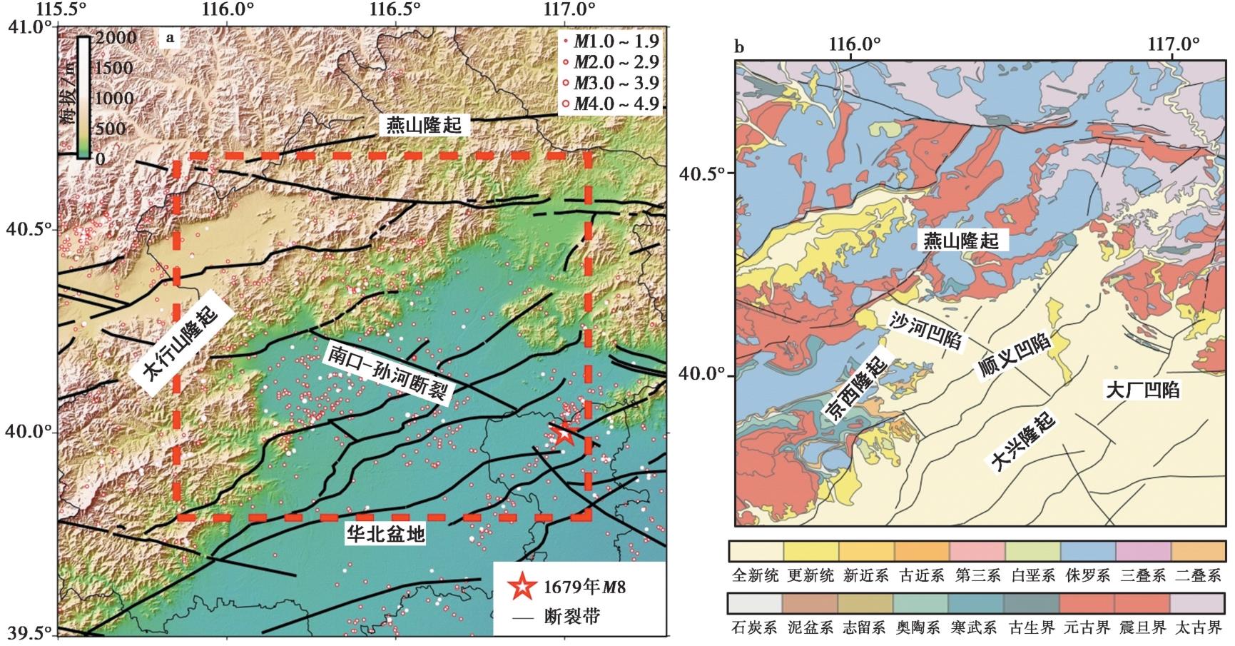
图1 北京及周边地区历史地震(a)及区域地质构造分布图(b)
Fig. 1 Distribution of seismic earthquakes in Beijing and its surrounding areas(a) and geological setting of the study area(b).
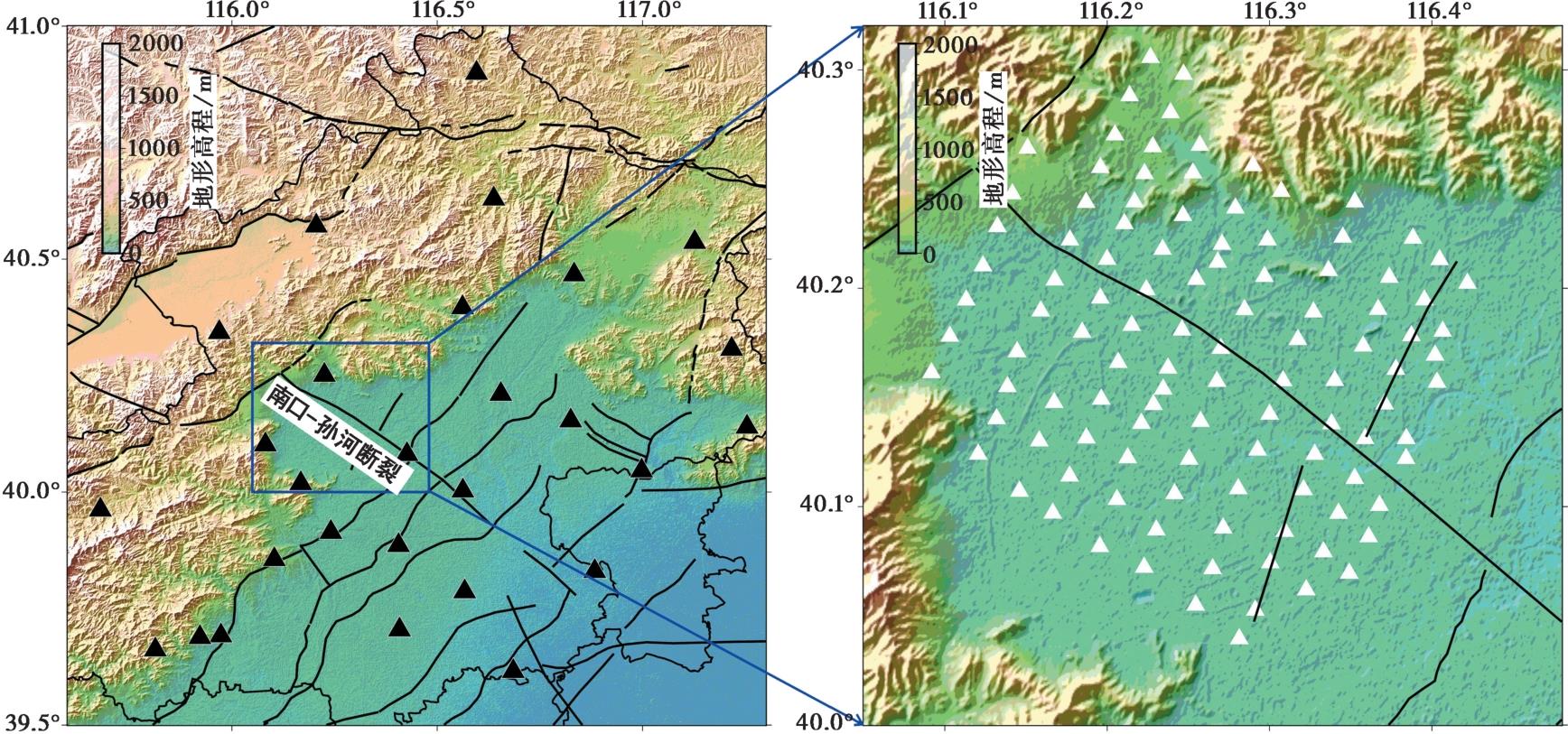
图2 北京地区固定台站(黑色三角)和布设在南口-孙河断裂周边流动台站(白色三角)分布图
Fig. 2 Location map of the permanent seismic stations in the Beijing region (black triangles) and the temporary seismic stations deployed around the Nankou-Sunhe Fault(white triangles).

图3 互相关波形、初始速度模型及瑞利波群速度频散曲线图 a 北京地区固定地震台站噪声互相关函数; b 固定台瑞利波群速度频散曲线数据, 其中灰色实线代表不同路径的频散分布, 蓝色虚线代表各个周期下频散曲线的数量, 红色点代表各个周期下频散数据的均值; c 初始速度模型; d 短周期流动台站的瑞利波群速度频散曲线数据
Fig. 3 Cross-correlation functions, initial velocity model, and the Rayleigh wave group velocity dispersion curves.

图4 不同周期瑞利波群速度射线的路径分布 a—d 固定台站的群速度路径射线分布, 对应周期分别为4s、6s、8s、10s; e—h流动台站的群速度射线路径分布, 对应周期分别为0.3s、0.7s、1.1s、1.7s。红色小三角代表台站, 黑线代表群速度射线
Fig. 4 Distribution of Rayleigh wave group velocity ray paths at different periods.
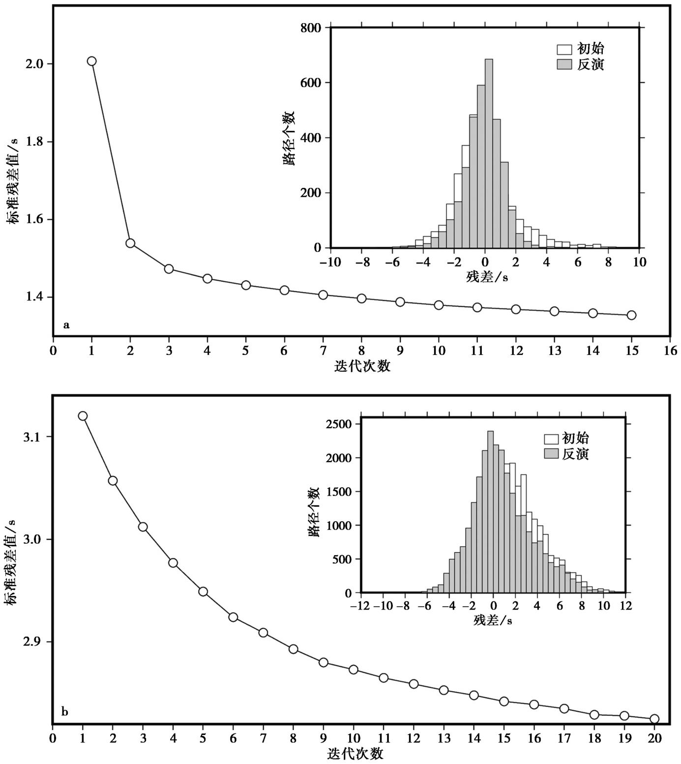
图5 北京地区(a)和昌平区(b)走时残差均方差随迭代次数的变化曲线及反演前、后的走时残差分布图(白色和灰色柱状图)
Fig. 5 The standard deviation of travel-time residuals of each iteration step in the Beijing area(a) and Changping area(b), along with the distribution of travel-time residuals before and after inversion(white and gray bar graphs).
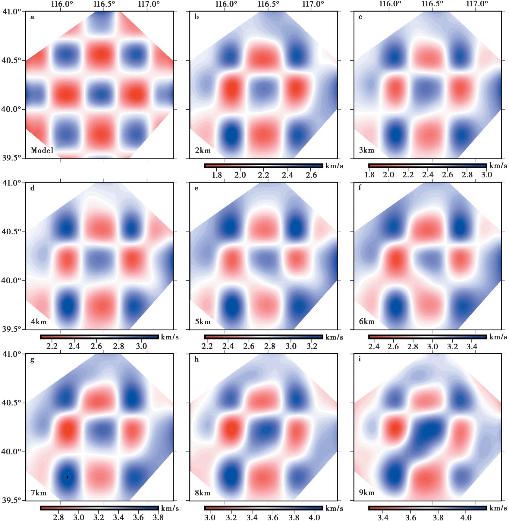
图6 北京地区不同深度的检测板测试结果 a 输入模型; b—i 2km、3km、4km、5km、6km、7km、8km、9km深度的模型恢复图
Fig. 6 Checkerboard test for group velocity inversion at different depths in the Beijing area.
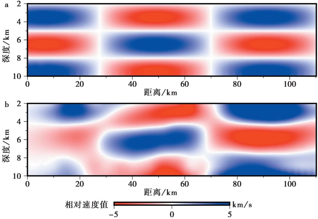
图7 沿40.2°N的垂向检测板测试结果 a 输入模型; b 模型恢复图
Fig. 7 Checkerboard test for the vertical profile along latitude 40.3°N.
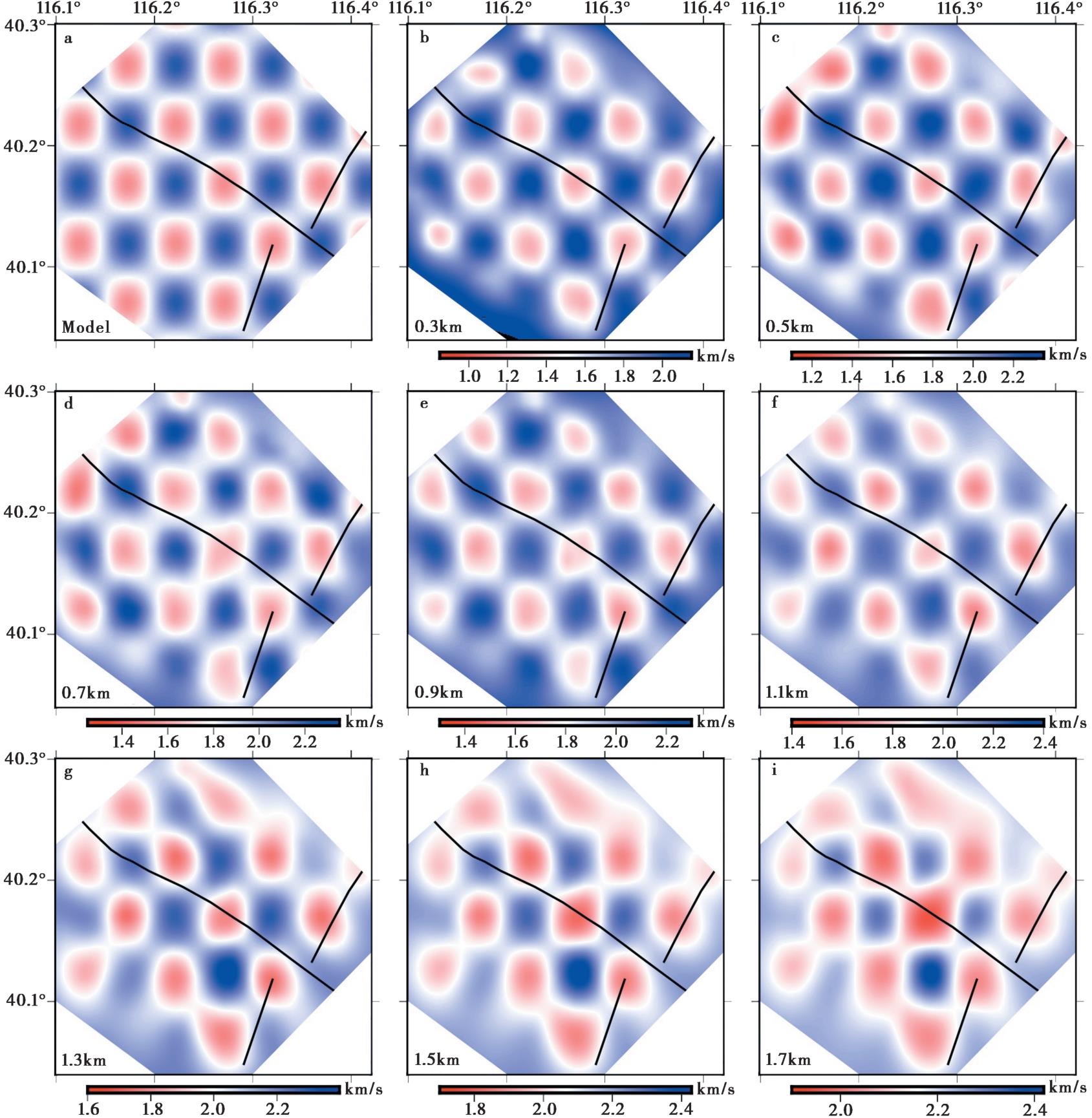
图8 北京昌平地区不同深度检测板测试结果图 a 输入模型; b—i 0.3km、0.5km、0.7km、0.9km、1.1km、1.3km、1.5km、1.7km深度的模型恢复图
Fig. 8 Checkerboard test for group velocity inversion at different depths in the Changping area of Beijing.
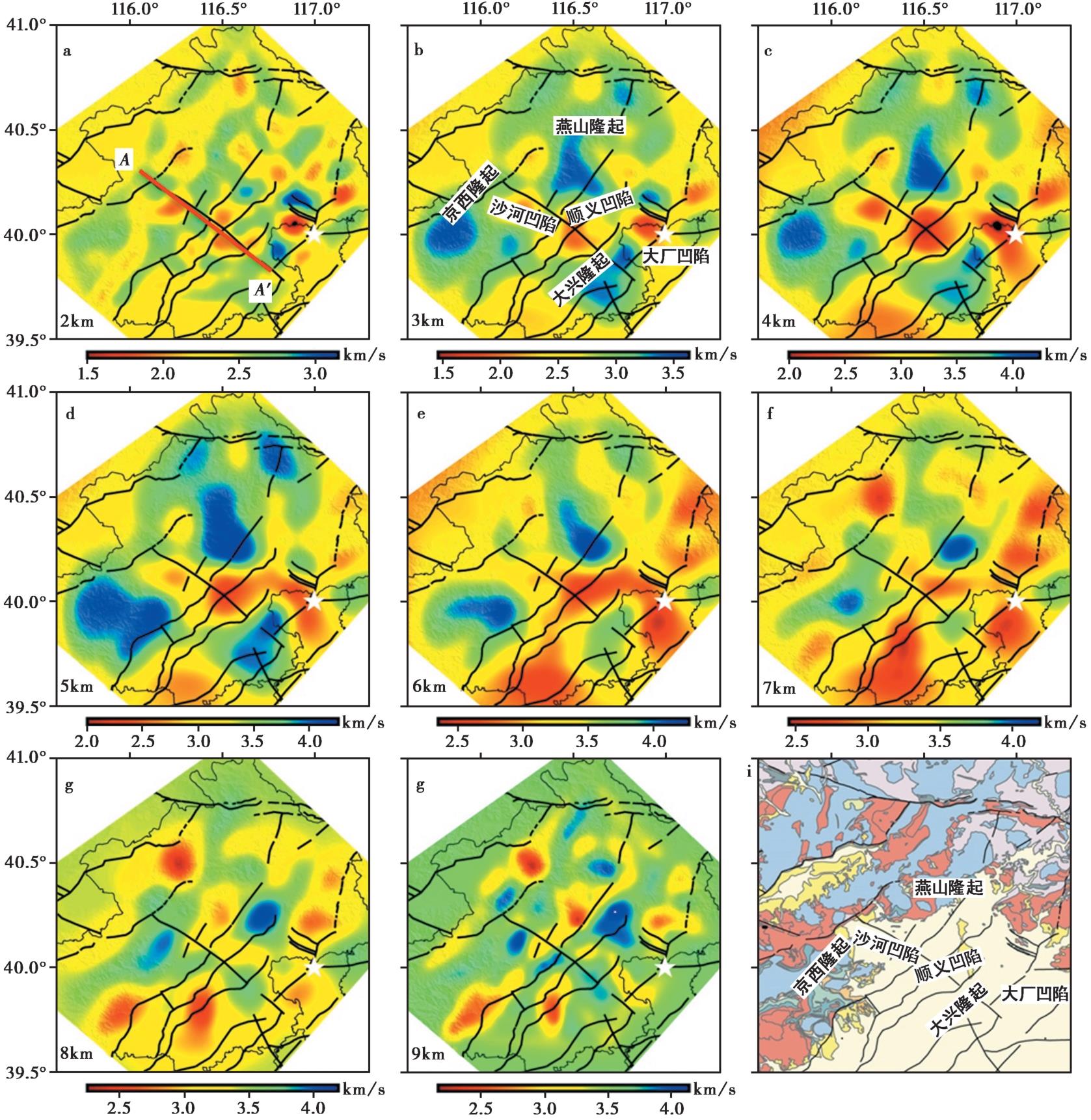
图9 北京地区不同深度S波速度分布图 a—h 深度为2km、3km、4km、5km、6km、7km、8km、9km的北京地区成像结果平面图; i 地质构造图
Fig. 9 The S-wave velocity distribution at different depths beneath the Beijing area.
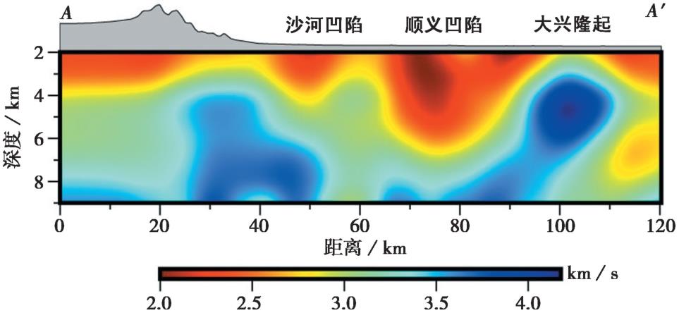
图10 沿南口-孙河断裂方向的速度结构剖面图 剖面位置见图9a
Fig. 10 Velocity structure profile along the Nankou-Sunhe Fault.
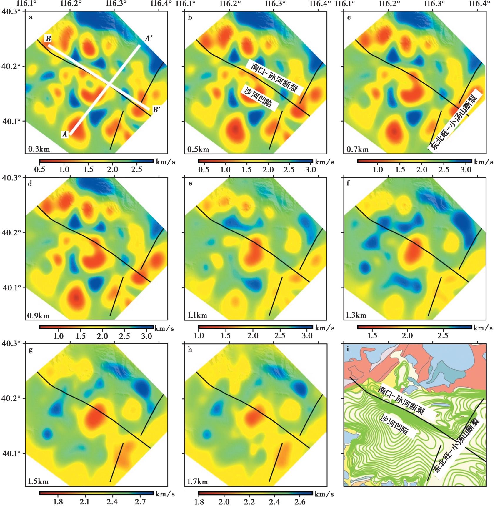
图11 昌平地区不同深度的S波速度分布 a—h 深度为0.3km、0.5km、0.7km、0.9km、1.1km、1.3km、1.5km、1.7km的北京昌平地区成像结果平面图; i 沉积层等值线分布图
Fig. 11 The S-wave velocity distribution at different depths beneath the Changping area.
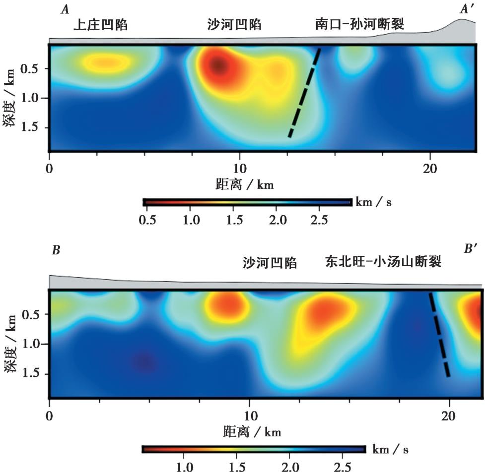
图12 速度结构剖面图 AA'和BB'的位置见图11a, 虚线代表断层位置
Fig. 12 Velocity structure profile.
| [1] |
蔡向民, 张磊, 郭高轩, 等. 2016. 北京平原地区第四纪地质研究新进展[J]. 中国地质, 43(3): 1055—1066.
|
|
|
|
| [2] |
陈成沟, 邢成起, 胡乐银, 等. 2017. 北京及其邻区小震重定位与活动构造分析[J]. 地震, 37(3): 84—94.
|
|
|
|
| [3] |
高战武, 陈棋福, 黄金莉, 等. 2010. 北京地区主要活动断裂深部速度结构特征及强震构造分析[J]. 震灾防御技术, 5(3): 271—280.
|
|
|
|
| [4] |
何仲太, 马保起, 卢海峰, 等. 2009. 北京东北旺-小汤山断裂存在的证据[J]. 地震地质, 31(2), 233—246.
|
|
|
|
| [5] |
嘉世旭, 齐诚, 王夫运, 等. 2005. 首都圈地壳网格化三维结构[J]. 地球物理学报, 48(6): 1316—1324.
|
|
|
|
| [6] |
嘉世旭, 张成科, 赵金仁, 等. 2009. 华北东北部裂陷盆地与燕山隆起地壳结构[J]. 地球物理学报, 52(1): 99—110.
|
|
|
|
| [7] |
江娃利, 侯治华, 谢新生. 2001. 北京平原南口—孙河断裂带昌平旧县探槽古地震事件研究[J]. 中国科学(D辑), 31(6): 501—509.
|
|
|
|
| [8] |
雷坤超, 罗勇, 陈蓓蓓, 等. 2016. 北京平原区地面沉降分布特征及影响因素[J]. 中国地质, 43(6): 2216—2225.
|
|
|
|
| [9] |
李乐, 陈棋福, 陈颙. 2007. 首都圈地震活动构造成因的小震精定位分析[J]. 地球物理学进展, 22(1): 24—34.
|
|
|
|
| [10] |
李松林, 张先康, 宋占隆, 等. 2001. 多条人工地震测深剖面资料联合反演首都圈三维地壳结构[J]. 地球物理学报, 44(3): 360—368.
|
|
|
|
| [11] |
梁亚南. 2019. 北京南口-孙河断裂带(北段)的结构及活动性[J]. 地质通报, 38(5): 858—865.
|
|
|
|
| [12] |
刘保金, 胡平, 孟勇奇, 等. 2009. 北京地区地壳精细结构的深地震反射剖面探测研究[J]. 地球物理学报, 52(9): 2264—2272.
|
|
|
|
| [13] |
冉勇康, 邓起东, 杨晓平, 等. 1997. 1679年三河-平谷8级地震发震断层的古地震及重复间隔[J]. 地震地质, 19(3): 193—201.
|
|
|
|
| [14] |
王夫运, 张先康, 陈棋福, 等. 2005. 北京地区上地壳三维细结构层析成像[J]. 地球物理学报, 48(2): 359—366.
|
|
|
|
| [15] |
王娟娟, 姚华建, 王伟涛, 等. 2018. 基于背景噪声成像方法的新疆呼图壁储气库地区近地表速度结构研究[J]. 地球物理学报, 61(11): 4436—4447.
|
|
|
|
| [16] |
汪良谋, 徐杰, 黄秀铭, 等. 1990. 北京拗陷构造活动性分析[J]. 中国地震, 6(2): 25—36.
|
|
|
|
| [17] |
徐杰, 洪汉净, 赵国泽, 等. 1985. 华北平原新生代裂陷盆地的演化及运动学特征 [G]//国家地震局地质研究所编. 现代地壳运动研究. 北京: 地震出版社: 26—40.
|
|
|
|
| [18] |
徐微, 丁志峰, 吴萍萍, 等. 2022. 利用密集台阵背景噪声研究通州三河地区高分辨率三维 S 波速度结构[J]. 地球物理学报, 65(12): 4685—4703.
|
|
|
|
| [19] |
徐锡伟, 吴卫民, 张先康, 等. 2002. 首都圈地区地壳最新构造变动与地震[M]. 北京: 科学出版社.
|
|
|
|
| [20] |
姚华建, 徐果明, 肖翔, 等. 2004. 基于图像分析的双台面波相速度频散曲线快速提取方法[J]. 地震地磁观测与研究, 25(1): 1—8.
|
|
|
|
| [21] |
张风雪, 李永华, 吴庆举, 等. 2011. FMTT方法研究华北及邻区上地幔 P 波速度结构[J]. 地球物理学报, 54(5): 1233—1242.
|
|
|
|
| [22] |
张广伟, 雷建设, 谢富仁, 等. 2011. 华北地区小震精定位及构造意义[J]. 地震学报, 33(6): 699—714.
|
|
|
|
| [23] |
张磊, 白凌燕, 赵勇, 等. 2017. 北京南口-孙河断裂与黄庄-高丽营断裂交会区沉积速率差异对断裂活动性的响应[J]. 地震地质, 39(5): 1048—1065. doi: 10.3969/j.issn.0253-4967.2017.05.013.
|
|
|
|
| [24] |
张磊, 何静, 白凌燕, 等. 2016. 北京凹陷北缘第四纪凹陷盆地沉积速率变化特征与顺义断裂活动性的响应关系[J]. 中国地质, 43(2): 511—519.
|
|
|
|
| [25] |
张晓亮, 张磊, 王志辉, 等. 2020. 基于磁性地层和沉积地层特征对北京市南口-孙河断裂活动性评估[J]. 中国地质, 47(3): 868—878.
|
|
|
|
| [26] |
赵博, 高原, 石玉涛, 等. 2013. 用双差定位结果分析华北地区的地震活动[J]. 地震, 33(1): 12—21.
|
|
|
|
| [27] |
赵勇, 蔡向民, 王继明, 等. 2015. 北京平原构造断块划分及微断块第四纪活动性探讨[J]. 中国地质, 42(6): 1876—1884.
|
|
|
|
| [28] |
|
| [29] |
|
| [30] |
|
| [31] |
|
| [32] |
|
| [33] |
|
| [34] |
|
| [35] |
|
| [36] |
|
| [37] |
|
| [38] |
|
| [39] |
|
| [40] |
|
| [41] |
|
| [1] | 冯策, 宋秀青, 王仁涛, 刘昊岚. 基于背景噪声层析成像反演上海及邻区S波速度结构[J]. 地震地质, 2024, 46(6): 1374-1390. |
| [2] | 曹颖, 钱佳威, 黄江培, 周青云. 云南洱源地区地壳三维精细速度结构成像[J]. 地震地质, 2024, 46(1): 162-183. |
| [3] | 周铭, 段永红, 檀玉娟, 邱勇. 基于密集台阵的东濮凹陷中北段浅层速度结构[J]. 地震地质, 2023, 45(2): 517-535. |
| [4] | 罗仁昱, 陈继锋, 尹欣欣, 李少华. 青海共和及周边地区的地壳三维速度结构[J]. 地震地质, 2021, 43(1): 232-248. |
| [5] | 李霞, 陈时军, 张正帅, 戴宗辉, 李小晗, 卢仲斌. 山东庙岛群岛地区P波三维速度结构反演与2017年震群的发震构造分析[J]. 地震地质, 2020, 42(5): 1188-1204. |
| [6] | 张娜, 赵翠萍, 李春宏, 周连庆. 基于加密观测的金沙江下游水库区速度结构成像[J]. 地震地质, 2019, 41(6): 1380-1394. |
| [7] | 李细兵, 熊振, 范小平, 陶小三, 彭小波. 福建地区地壳上地幔顶部三维速度结构及构造意义[J]. 地震地质, 2019, 41(5): 1206-1222. |
| [8] | 熊诚, 谢祖军, 郑勇, 熊熊, 艾三喜, 谢仁先. 大别—郯庐造山带地壳上地幔Rayleigh面波层析成像[J]. 地震地质, 2019, 41(1): 1-20. |
| [9] | 张磊, 白凌燕, 赵勇, 张晓亮, 杨天水, 蔡向民, 何付兵. 北京南口-孙河断裂与黄庄-高丽营断裂交会区沉积速率差异对断裂活动性的响应[J]. 地震地质, 2017, 39(5): 1048-1065. |
| [10] | 谢辉, 马禾青, 焦明若, 马小军, 张楠, 李青梅. 利用背景噪声成像技术反演宁夏及邻区S波速度结构[J]. 地震地质, 2017, 39(3): 605-622. |
| [11] | 王同利, 胡乐银, 崔博闻, 宋艳茹. 北京城市轨道交通对地电场观测的干扰影响[J]. 地震地质, 2013, 35(4): 887-893. |
| [12] | 张世民, 王丹丹, 刘旭东, 任俊杰, 罗明辉, 张国宏, 赵国存, 王瑞, 张英礼. 北京南口-孙河断裂带北段晚第四纪活动的层序地层学研究[J]. 地震地质, 2007, 29(4): 729-743. |
| [13] | 张先, 赵丽. 利用磁异常解析方法试验研究城市断裂[J]. 地震地质, 2007, 29(2): 336-353. |
| [14] | 黄秀铭, 汪良谋, 徐杰, 方仲景, 张裕明, 向家翠, 王辉. 北京地区新构造运动特征[J]. 地震地质, 1991, 13(1): 43-51. |
| 阅读次数 | ||||||
|
全文 |
|
|||||
|
摘要 |
|
|||||
