地震地质 ›› 2025, Vol. 47 ›› Issue (1): 267-283.DOI: 10.3969/j.issn.0253-4967.2025.01.016
酆少英( ), 刘保金, 左莹, 姬计法, 谭雅丽, 丁奎, 武泉
收稿日期:2024-07-10
修回日期:2024-09-23
出版日期:2025-02-20
发布日期:2025-04-09
作者简介:酆少英, 男, 1967年生, 博士, 正高级工程师, 长期从事地壳深浅结构的反射地震探测与研究, E-mail: fsy.ny@163.com。
基金资助:
FENG Shao-ying(), LIU Bao-jin, ZUO Ying, JI Ji-fa, TAN Ya-li, DING Kui, WU Quan
Received:2024-07-10
Revised:2024-09-23
Online:2025-02-20
Published:2025-04-09
摘要: 为研究太行山南端地壳精细结构, 在太行山南端的辉县—长垣之间布设了一条长约120km的深地震反射剖面。结果显示, 该区地壳结构分层特征性明显, 总地壳厚33.5~42.7km。上地壳厚13.3~20.1km, 东薄西厚; 下地壳有良好的反射性质, 由一系列反射能量较强的弧状或倾斜强反射构成。壳幔分界面反射能量较强, 横向连续性较好, 自东向西呈逐渐加深的形态。剖面沿线的断裂构造较为发育, 共解释了11条断层, 其中10条为上地壳内发育的断层。汤东断裂为汤阴断陷的主控边界断裂, 向下以铲形正断层方式切割了沉积地层和基底, 约在15~16km深度处归并到上、下地壳分界面上。在汤阴断陷的南东侧, 剖面上存在一个近垂直的条带状反射能量减弱带或壳内界面的不连续带, 自上而下切割了上、下地壳分界面、下地壳及壳幔分界面, 属于地壳尺度的深大断裂。该断裂带记录了与剖面下方软流圈上升流相关的岩浆底侵作用, 为深部热物质的上涌提供了通道, 而深部物质的上涌、岩浆底侵或热侵蚀作用导致地壳出现拉张伸展。
酆少英, 刘保金, 左莹, 姬计法, 谭雅丽, 丁奎, 武泉. 利用深地震反射剖面研究太行山南端的地壳精细结构和构造[J]. 地震地质, 2025, 47(1): 267-283.
FENG Shao-ying, LIU Bao-jin, ZUO Ying, JI Ji-fa, TAN Ya-li, DING Kui, WU Quan. THE STUDY OF FINE CRUSTAL STRUCTURE OF THE SOUTHERN MARGIN OF TAIHANG MOUNTAIN BY DEEP SEISMIC REFLECTION PROFILE[J]. SEISMOLOGY AND GEOLOGY, 2025, 47(1): 267-283.
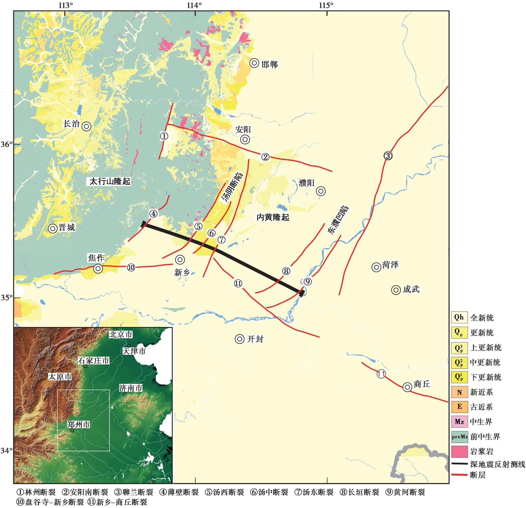
图1 测区构造背景及深地震反射剖面位置示意图
Fig. 1 Tectonic setting of the dection area and the location of deep seismic reflection profile.
| 项目 | 类别 | 工作参数 |
|---|---|---|
| 激发参数 | 激发源类型 | 中密度震源药柱 |
| 炮间距 | 小炮间距280m,大炮间距2000m | |
| 激发药量 | 小炮40kg,大炮120kg | |
| 激发井深 | 小炮25m,大炮3×40m | |
| 接收参数 | 道间距 | 40m |
| 接收道数 | 800道 | |
| 采样间隔 | 4ms | |
| 记录道长 | 30s |
表1 激发和接收参数表
Table1 Excitation and reception parameters
| 项目 | 类别 | 工作参数 |
|---|---|---|
| 激发参数 | 激发源类型 | 中密度震源药柱 |
| 炮间距 | 小炮间距280m,大炮间距2000m | |
| 激发药量 | 小炮40kg,大炮120kg | |
| 激发井深 | 小炮25m,大炮3×40m | |
| 接收参数 | 道间距 | 40m |
| 接收道数 | 800道 | |
| 采样间隔 | 4ms | |
| 记录道长 | 30s |
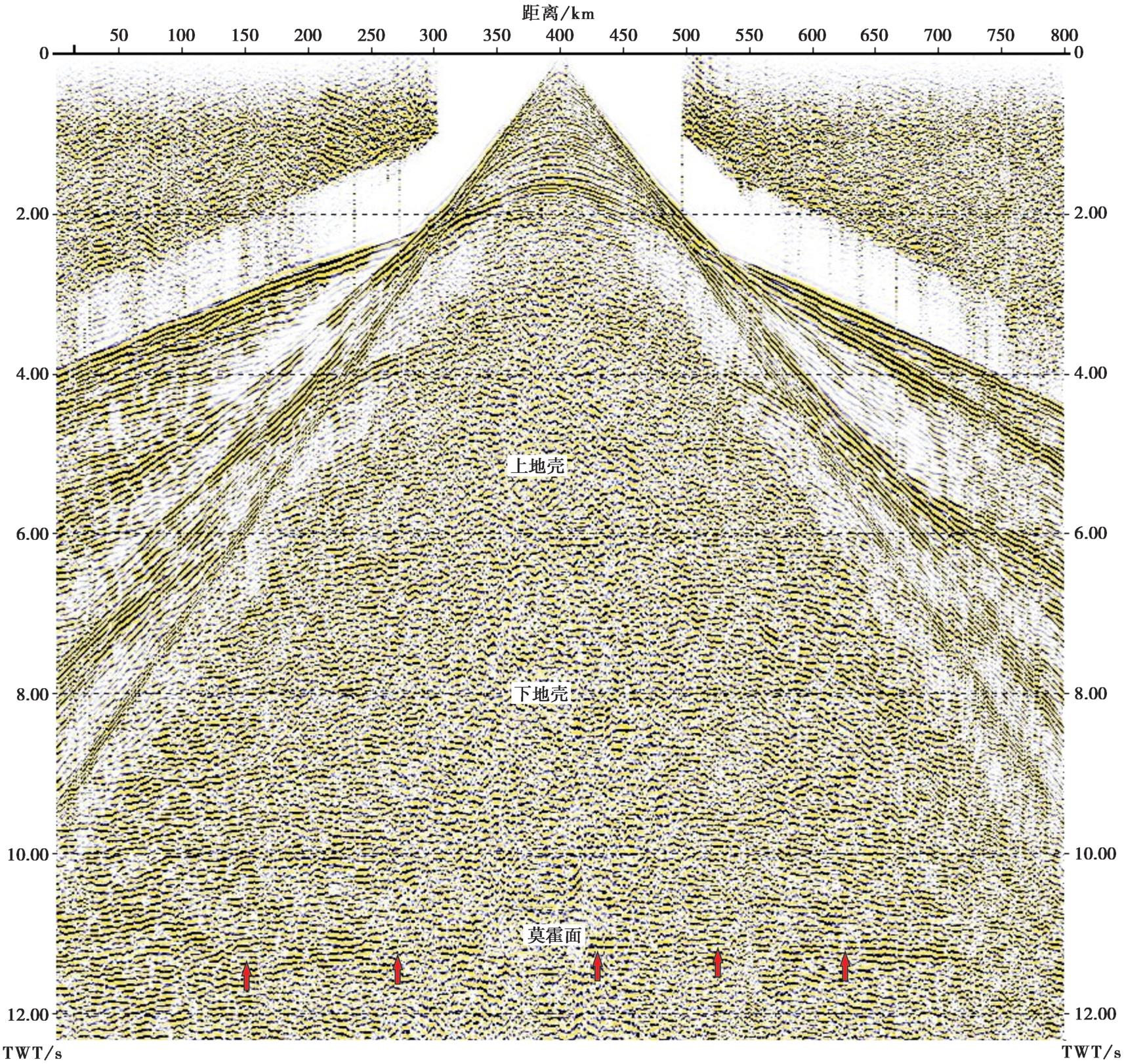
图2 太行山南端深地震反射剖面原始记录
Fig. 2 The original seismic record of deep seismic reflection profile in the southern margin of Taihang Mountain.
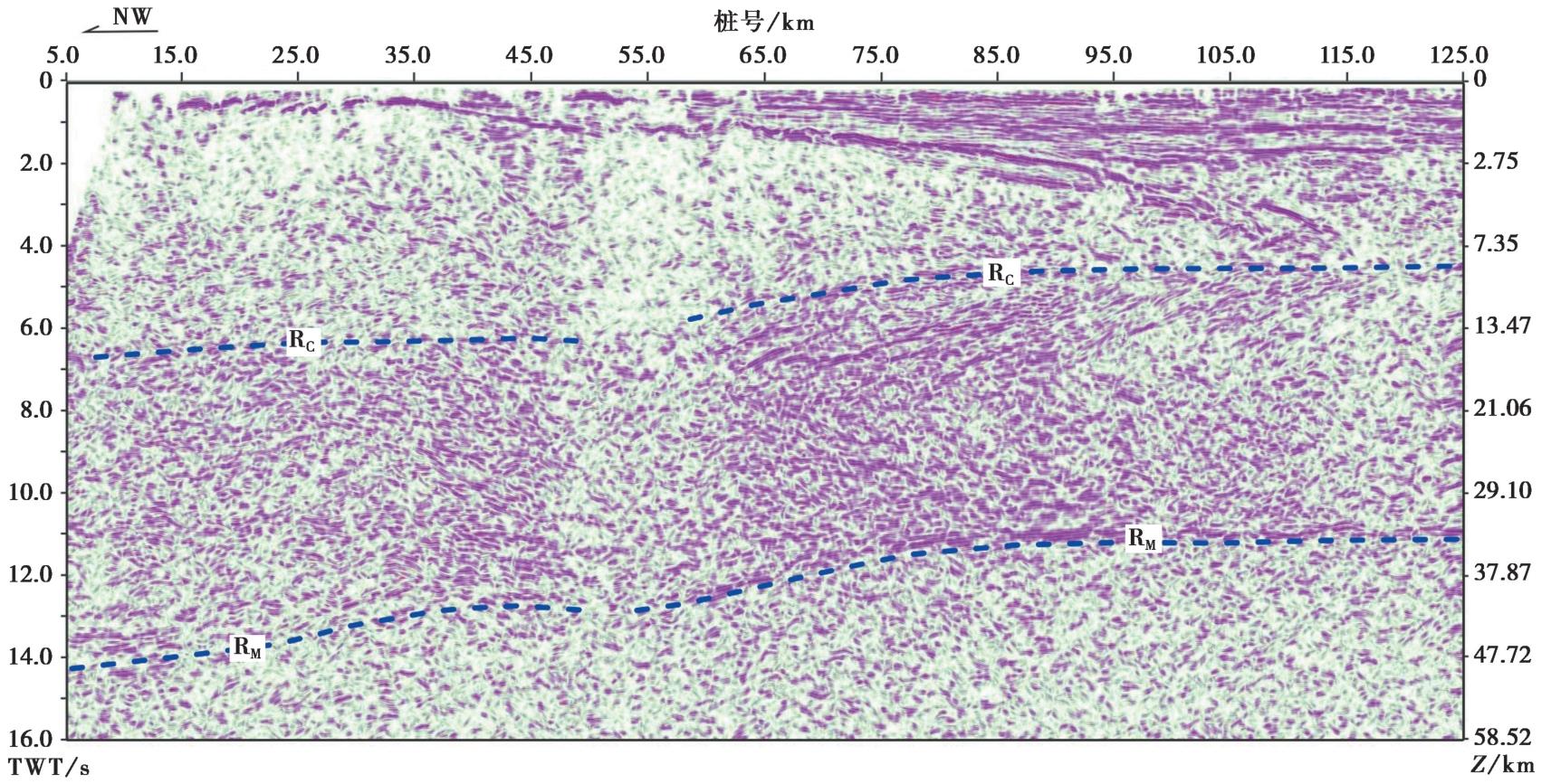
图3 太行山南端深地震反射叠加时间剖面
Fig. 3 The stacked profile of deep seismic reflection in the southern margin of Taihang Mountain.
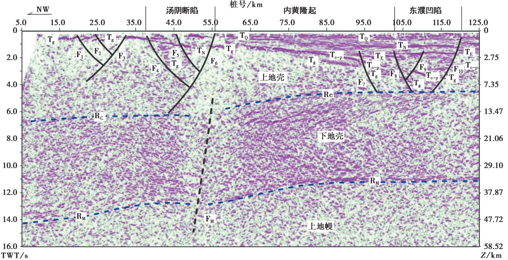
图4 太行山南端深地震反射叠加时间剖面解释结果
Fig. 4 The profile interpretation of deep seismic reflection in the southern margin of Taihang Mountain.
| [1] |
安慧婷, 许立青, 李三忠, 等. 2015. 太行山东麓断裂带中、新生代构造应力场及转换机制[J]. 大地构造与成矿学, 39(4): 571—586.
|
|
|
|
| [2] |
曹现志, 李三忠, 刘鑫, 等. 2013. 太行山东麓断裂带板内构造地貌反转与机制[J]. 地学前缘, 20(4): 88—103.
|
|
|
|
| [3] |
陈国光, 徐杰, 高占武. 2003. 华北渤海湾盆地大震的构造特征[J]. 华北地震科学, 21(2): 7—15.
|
|
|
|
| [4] |
陈凌, 危自根, 程骋. 2010. 从华北克拉通中、西部结构的区域差异性探讨克拉通破坏[J]. 地学前缘, 17(1): 212—228.
|
|
|
|
| [5] |
方怡. 2012. 华北地区现代强震地震地质灾害数据库平台建立[D]. 兰州: 中国地震局兰州地震研究所.
|
|
|
|
| [6] |
酆少英, 刘保金, 姬计法, 等. 2015. 呼和浩特-包头盆地岩石圈细结构的深地震反射探测[J]. 地球物理学报, 58(4): 1158—1168.
|
|
|
|
| [7] |
酆少英, 刘保金, 李倩, 等. 2020. 深地震反射剖面揭示的华北地块南缘地壳的精细结构[J]. 地震地质, 42(3): 581—594.
|
|
|
|
| [8] |
高锐, 马永生, 李秋生, 等. 2006. 松潘地块与西秦岭造山带下地壳的性质和关系: 深地震反射剖面的揭露[J]. 地质通报, 25(12): 1361—1367.
|
|
|
|
| [9] |
韩慕康, 赵景珍. 1980. 河南汤阴地堑的地震地质特征与地震危险性[J]. 地震地质, 2(4): 47—58.
|
|
|
|
| [10] |
韩晓明, 刘芳, 张帆, 等. 2018. 鄂尔多斯块体东北缘的P波速度精细结构[J]. 地震地质, 40(1): 215—231. doi: 10.3969/j.issn.0253-4967.2018.03.013.
|
|
|
|
| [11] |
韩竹军, 徐杰, 冉勇康, 等. 2003. 华北地区活动地块与强震活动[J]. 中国科学(D辑), 33(S1): 108—118.
|
|
|
|
| [12] |
黄汲清. 1980. 中国大地构造及其演化: 1︰400万中国大地构造图简要说明[M]. 北京: 科学出版社.
|
|
|
|
| [13] |
姬磊喆. 2013. 太行山山前断裂带电性结构分析及构造特征研究[D]. 北京: 中国地质大学.
|
|
|
|
| [14] |
嘉世旭, 刘昌铨. 1991. 华北裂谷盆地南部菏泽-长治地震测深剖面结果解释[J]. 华北地震科学, 9(2): 11—20.
|
|
|
|
| [15] |
嘉世旭, 张先康. 2005. 华北不同构造块体地壳结构及其对比研究[J]. 地球物理学报, 48(3): 611—620.
|
|
|
|
| [16] |
江娃利, 聂宗笙. 1984. 太行山山前断裂带活动特征及地震危险性讨论[J]. 华北地震科学, 2(3): 21—27.
|
|
|
|
| [17] |
李继东. 2008. 东濮凹陷构造特征与断块群成藏条件分析[D]. 北京: 中国地质大学.
|
|
|
|
| [18] |
李三忠, 索艳慧, 戴黎明, 等. 2010. 渤海湾盆地形成与华北克拉通破坏[J]. 地学前缘, 17(4): 64—89.
|
|
|
|
| [19] |
李庶波, 王岳军, 张玉芝, 等. 2015. 南太行山中新生代隆升过程: 磷灰石裂变径迹证据[J]. 大地构造与成矿学, 39(3): 460—469.
|
|
|
|
| [20] |
刘保金, 酆少英, 姬计法, 等. 2015. 郯庐断裂带中南段的岩石圈精细结构[J]. 地球物理学报, 58(5): 1610—1621.
|
|
|
|
| [21] |
刘保金, 何宏林, 石金虎, 等. 2012. 太行山东缘汤阴地堑地壳结构和活动断裂探测[J]. 地球物理学报, 55(10): 3266—3276.
|
|
|
|
| [22] |
刘尧兴, 周庆, 荆智国, 等. 2000. 豫北地区新构造活动特征及中长期地震预报研究[M]. 西安: 陕西地图出版社.
|
|
|
|
| [23] |
卢占武, 高锐, 王海燕, 等. 2014. 深地震反射剖面上的“亮点”构造[J]. 地球物理学进展, 29(6): 2518—2525.
|
|
|
|
| [24] |
马杏垣, 刘昌铨, 刘国栋. 1991. 江苏响水至内蒙古满都拉地学断面[J]. 地质学报, 65(3): 199—215.
|
|
|
|
| [25] |
秦晶晶, 袁洪克, 何银娟, 等. 2018. 层析成像技术在城市活断层探测中的应用[J]. 地球物理学进展, 33(5): 2153—2158.
|
|
|
|
| [26] |
单帅强. 2018. 太行山山前断层的构造几何学运动学及其对渤海湾盆地发育的控制作用[D]. 北京: 中国地质大学.
|
|
|
|
| [27] |
唐新功, 陈永顺, 严良俊, 等. 2008. 应用布格重力异常研究太行山地区地壳密度结构[J]. 西北地震学报, 30(4): 305—309.
|
|
|
|
| [28] |
田俊伟. 2015. 太行山构造演化对焦作矿区瓦斯赋存的控制研究[J]. 煤炭科学技术, 43(7): 127—130.
|
|
|
|
| [29] |
王椿镛, 张先康, 吴庆举, 等. 1994. 华北盆地滑脱构造的地震学证据[J]. 地球物理学报, 37(5): 613—620.
|
|
|
|
| [30] |
王海燕, 高锐, 李秋生, 等. 2014. 青藏高原松潘—西秦岭—临夏盆地深地震反射剖面: 采集、处理与初步解释[J]. 地球物理学报, 57(5): 1451—1461.
|
|
|
|
| [31] |
王海燕, 高锐, 卢占武, 等. 2010. 深地震反射剖面揭露大陆岩石圈精细结构[J]. 地质学报, 84(6): 818—839.
|
|
|
|
| [32] |
王志铄. 2017. 河南省地震构造特征[M]. 北京: 地震出版社.
|
|
|
|
| [33] |
吴忱, 张秀清, 马永红. 1999. 太行山燕山主要隆起于第四纪[J]. 华北地震科学, 17(3): 1—7.
|
|
|
|
| [34] |
吴智平, 侯旭波, 李伟. 2007. 华北东部地区中生代盆地格局及演化过程探讨[J]. 大地构造与成矿学, 31(4): 385—399.
|
|
|
|
| [35] |
莘海亮, 刘明军, 张元生, 等. 2017. 太行山断裂带东南缘地壳三维P波速度结构成像[J]. 地震工程学报, 39(1): 141—149.
|
|
|
|
| [36] |
熊熊, 许厚泽. 2000. 地幔对流诱发的莫霍面起伏与下地壳塑性流动[J]. 测绘学报, 29(S1): 21—25.
|
|
|
|
| [37] |
徐杰, 高战武, 孙建宝, 等. 2001. 区域伸展体制下盆-山构造耦合关系的探讨: 以渤海湾盆地和太行山为例[J]. 地质学报, 75(2): 165—174.
|
|
|
|
| [38] |
徐杰, 高战武, 宋长青, 等. 2000. 太行山山前断裂带的构造特征[J]. 地震地质, 22(2): 111—122.
|
|
|
|
| [39] |
徐杰, 周本刚, 计凤桔, 等. 2012. 华北渤海湾盆地区大震发震构造的基本特征[J]. 地震地质, 34(4): 618—636. doi: 10.3969/j.issn.0253-4967.2012.04.008.
|
|
|
|
| [40] |
徐明才, 高景华, 荣立新, 等. 2010. 地震方法探测太行山山前断裂的活动特征[J]. 应用地球物理, 7(4): 392—398.
|
|
|
|
| [41] |
徐增波. 2018. 用地震反射资料研究太行山南端辉县—封丘剖面精细结构[D]. 北京: 中国地震局地球物理研究所.
|
|
|
|
| [42] |
徐志萍, 姜磊, 杨利普, 等. 2015. 利用布格重力资料研究太行山东南缘断裂构造特征[J]. 大地测量与地球动力学, 35(3): 503—507.
|
|
|
|
| [43] |
徐志萍, 张扬, 杨利普, 等. 2022. 河南省及邻区主要活动断裂的深部构造特征[J]. 地震地质, 44(6): 1521—1538. doi: 10.3969/j.issn.0253-4967.2022.06.010.
|
|
|
|
| [44] |
杨文采. 1991. 用于岩石层调查的深地震反射[J]. 地球物理学进展, 6(3): 61—68.
|
|
|
|
| [45] |
杨晓平, 刘保金, 詹艳, 等. 2016. 太行山东缘石家庄南部地壳结构及断裂活动性探测[J]. 地球物理学报, 59(2): 528—542.
|
|
|
|
| [46] |
于慎谔, 赵俊香, 杨承先. 2012. 太行东断裂的性状与分布[J]. 中国地震, 28(1): 78—87.
|
|
|
|
| [47] |
张培震. 1999. 中国大陆岩石圈最新构造变动与地震灾害[J]. 第四纪研究, 19(5): 404—411.
|
|
|
|
| [48] |
张岳桥. 2004. 晚新生代青藏高原构造挤出及其对中国东部裂陷盆地晚期油气成藏的影响[J]. 石油与天然气地质, 25(2): 162—169.
|
|
|
|
| [49] |
张岳桥, 马寅生, 杨农. 2003. 太行山南缘断裂带新构造活动及其区域运动学意义[J]. 地震地质, 25(2): 169—182.
|
|
|
|
| [50] |
赵成彬, 刘保金, 姬计法, 等. 2013. 北京南部地壳精细结构深地震反射探测研究[J]. 地球物理学报, 56(4): 1168-l176.
|
|
|
|
| [51] |
赵金仁, 刘保金, 段永红, 等. 2017. 利用爆破地震揭示华北克拉通基底的高分辨速度结构: 大丰—包头折射剖面的探测结果[J]. 地球物理学报, 60(7): 2628—2640.
|
|
|
|
| [52] |
郑红霞, 张训华, 赵铁虎, 等. 2017. 渤海海峡及周边地应力分布规律与应力积累研究[J]. 岩石力学与工程学报, 36(2): 357—369.
|
|
|
|
| [53] |
朱红彬, 邢成起, 李红, 等. 2010. 华北构造区主要地震带分段与强震活动[J]. 地震学报, 32(6): 705—717.
|
|
|
|
| [54] |
朱日祥, 徐义刚, 朱光, 等. 2012. 华北克拉通破坏[J]. 中国科学(地球科学), 42(8): 1135—1159.
|
|
|
|
| [55] |
|
| [56] |
|
| [57] |
|
| [58] |
|
| [59] |
|
| [60] |
|
| [61] |
|
| [1] | 秦晶晶, 刘保金, 酆少英, 徐锡伟, 田一鸣, 朱国军, 左莹. 深地震反射剖面揭示沧县隆起和黄骅坳陷及邻区的地壳精细结构和构造特征[J]. 地震地质, 2024, 46(3): 608-626. |
| [2] | 李倩, 宋前进, 酆少英, 姬计法, 段永红, 何银娟, 秦晶晶. 深地震反射剖面揭示的兰聊断裂带中南段深部特征[J]. 地震地质, 2022, 44(4): 1029-1045. |
| [3] | 酆少英, 刘保金, 李倩, 袁洪克, 朱国军, 田一鸣, 王宏伟, 侯黎华, 邓小娟, 谭雅丽. 深地震反射剖面揭示的华北地块南缘地壳的精细结构[J]. 地震地质, 2020, 42(3): 581-594. |
| [4] | 秦晶晶, 赵成彬, 刘明军, 谭雅丽, 左莹, 刘英英. 太行山南端盘谷寺-新乡断裂的构造特征[J]. 地震地质, 2016, 38(1): 131-140. |
| [5] | 刘保金, 曲国胜, 孙铭心, 刘亢, 赵成彬, 徐锡伟, 酆少英, 寇昆朋. 唐山地震区地壳结构和构造:深地震反射剖面结果[J]. 地震地质, 2011, 33(4): 901-912. |
| 阅读次数 | ||||||
|
全文 |
|
|||||
|
摘要 |
|
|||||
