地震地质 ›› 2025, Vol. 47 ›› Issue (1): 167-188.DOI: 10.3969/j.issn.0253-4967.2025.01.011
魏占玉1,2)( ), 何宏林1,2), 邓亚婷1,2), 席茜1,2)
收稿日期:2024-01-08
修回日期:2024-03-24
出版日期:2025-02-20
发布日期:2025-04-09
作者简介:魏占玉, 男, 1981年生, 博士, 研究员, 研究方向为活动构造与构造地貌, E-mail: weizhanyu@ies.ac.cn。
基金资助:
WEI Zhan-yu1,2)(), HE Hong-lin1,2), DENG Ya-ting1,2), XI Xi1,2)
Received:2024-01-08
Revised:2024-03-24
Online:2025-02-20
Published:2025-04-09
摘要:
地震破裂带附近同震位移和变形模式对于深入理解地震破裂过程、断层行为及活动断层与地形地貌关系等至关重要。文中提出一种迭代最近点(ICP)算法, 利用地震前后地形点云进行差分确定断层近场三维同震地表位移。在川西大凉山断裂带交际河断层上选取2期SfM地形点云叠加同震位移场模拟震前-震后点云, 测试ICP方法获取同震位移场的精度。该方法在网格边长>50m的条件下可准确恢复同震位移场的方向和幅度, 水平和垂直精度分别为20~10cm, 这与地形点云定位精度相当。随着点云密度和网格窗口尺寸减小, 该方法恢复同震位移场等的精度将降低。通过分析树木生长、房屋建设、河流侵蚀等地形变化对恢复位移场的潜在影响, 研究结果表明扩大网格尺寸可使震前-震后点云具有足够地形结构进行匹配, 以减小局部地形变化对恢复位移场的影响, 网格窗口尺寸是在具有足够地形结构的大尺度和具有更精细分辨率的小尺度之间的权衡。文中所述的ICP方法利用震前-震后高精度点云可获取地震破裂带附近精细的三维地表位移场, 为浅层断层滑动和破裂带变形提供了新的约束, 有助于研究地震破裂过程和断层生长过程。
魏占玉, 何宏林, 邓亚婷, 席茜. 基于震前-震后高精度地形点云数据提取三维地表同震位移场信息[J]. 地震地质, 2025, 47(1): 167-188.
WEI Zhan-yu, HE Hong-lin, DENG Ya-ting, XI Xi. THREE-DIMENSIONAL SURFACE COSEISMIC DISPLACEMENTS FROM DIFFERENCING PRE- AND POST-EARTHQUAKE TERRAIN POINT CLOUDS[J]. SEISMOLOGY AND GEOLOGY, 2025, 47(1): 167-188.
| 控制点ID | X/m | Y/m | Z/m | X_err/m | Y_err/m | Z_err/m |
|---|---|---|---|---|---|---|
| GCP1 | 281937.2 | 3043654.3 | 2417.41 | 0.11 | 0.05 | 0.14 |
| GCP2 | 281511.2 | 3043984.3 | 2447.69 | 0.07 | 0.12 | 0.18 |
| GCP3 | 281599.8 | 3043479.6 | 2463.05 | 0.10 | 0.11 | 0.22 |
| GCP4 | 281074.5 | 3044292.1 | 2463.67 | 0.08 | 0.10 | 0.11 |
| GCP5 | 281145.7 | 3044564.7 | 2442.65 | 0.04 | 0.12 | 0.14 |
| GCP6 | 280745.4 | 3044789.5 | 2491.84 | 0.11 | 0.07 | 0.16 |
| GCP7 | 280864.7 | 3044540.2 | 2492.15 | 0.12 | 0.04 | 0.10 |
| GCP8 | 281154.8 | 3043974.3 | 2491.36 | 0.09 | 0.05 | 0.13 |
| GCP9 | 281479.9 | 3043723.6 | 2469.53 | 0.07 | 0.15 | 0.20 |
表1 地面控制点信息表
Table1 Ground control point information
| 控制点ID | X/m | Y/m | Z/m | X_err/m | Y_err/m | Z_err/m |
|---|---|---|---|---|---|---|
| GCP1 | 281937.2 | 3043654.3 | 2417.41 | 0.11 | 0.05 | 0.14 |
| GCP2 | 281511.2 | 3043984.3 | 2447.69 | 0.07 | 0.12 | 0.18 |
| GCP3 | 281599.8 | 3043479.6 | 2463.05 | 0.10 | 0.11 | 0.22 |
| GCP4 | 281074.5 | 3044292.1 | 2463.67 | 0.08 | 0.10 | 0.11 |
| GCP5 | 281145.7 | 3044564.7 | 2442.65 | 0.04 | 0.12 | 0.14 |
| GCP6 | 280745.4 | 3044789.5 | 2491.84 | 0.11 | 0.07 | 0.16 |
| GCP7 | 280864.7 | 3044540.2 | 2492.15 | 0.12 | 0.04 | 0.10 |
| GCP8 | 281154.8 | 3043974.3 | 2491.36 | 0.09 | 0.05 | 0.13 |
| GCP9 | 281479.9 | 3043723.6 | 2469.53 | 0.07 | 0.15 | 0.20 |
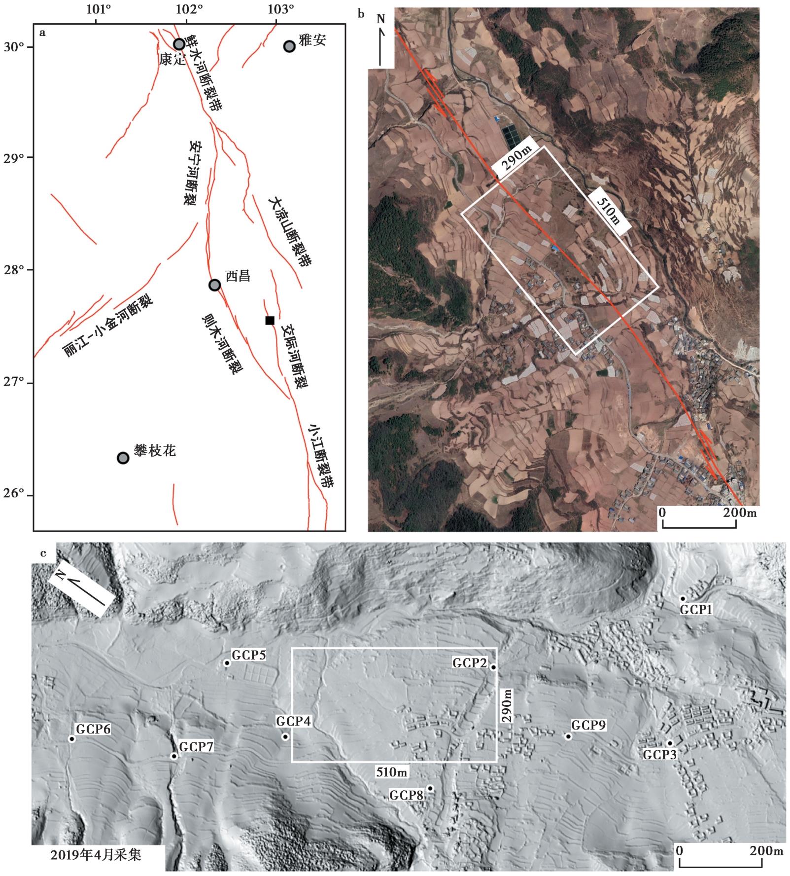
图1 实验地形点云数据采集 a 交际河断裂及数据采集位置, 黑块标识数据采集位置; b 数据采集区及附近断层位置, 底图为Google Earth影像; c SfM点云生成的DEM地势图, 白框为实验数据范围, 黑点及编号指示地面控制点位置及编号
Fig. 1 Experimental terrain point cloud data collection.
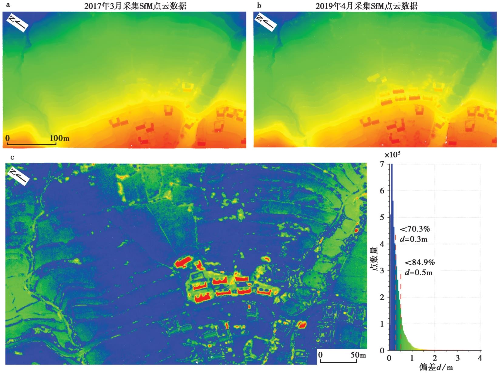
图2 2期SfM点云的高程渲染图和比较差异分布图 a、b SfM点云的高程渲染图; c 2期SfM点云比较差异的分布图
Fig. 2 Elevation rendering diagram and comparative difference distribution diagram of SfM point clouds in two periods.
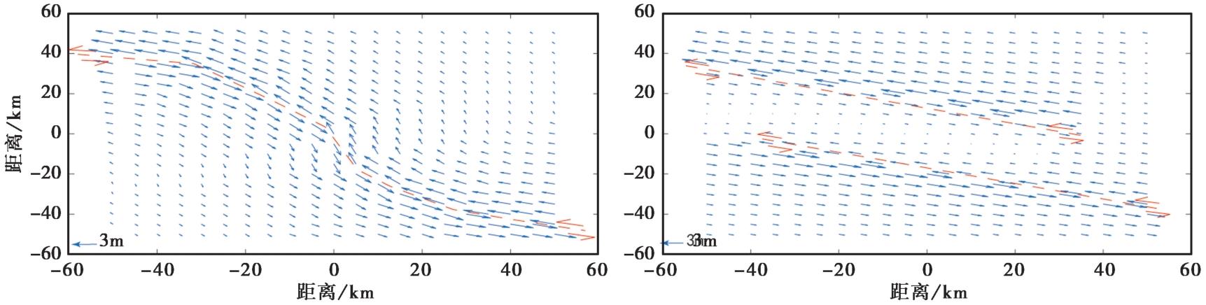
图3 同震水平位移场模拟 a 不同走向断层的同震水平位移场模拟; b 阶区断层的同震水平位移场模拟
Fig. 3 Simulation of coseismic horizontal displacement field.
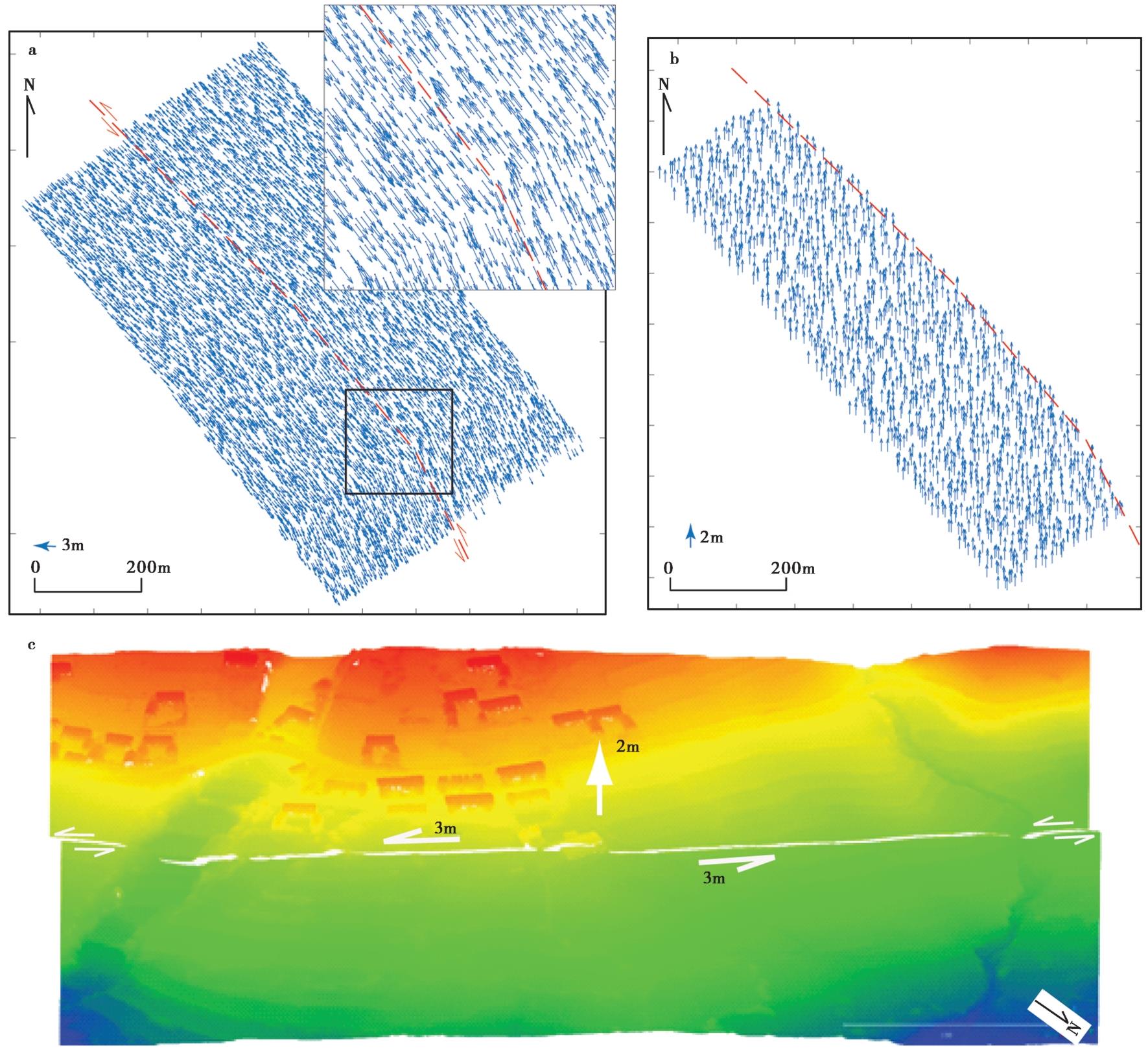
图4 模拟同震位移场和震后点云 a 模拟的同震水平位移矢量图, 断层两盘左旋滑动各3m; b 模拟的同震垂直位移矢量图, 断层南西盘垂直抬升2m, 北东盘无垂直位移; c SfM地形点云叠加三维模拟同震位移场后的点云高程渲染图
Fig. 4 Simulated coseismic displacement field and post-seismic point cloud.
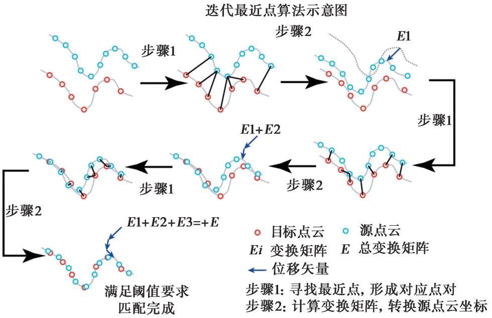
图5 迭代最近点(ICP)算法示意图
Fig. 5 Schematic diagram of the Closest Point of iteration(ICP)algorithm.
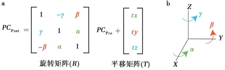
图6 三维刚体平移(T)和旋转(R)变换矩阵构成及坐标旋转示意图
Fig. 6 The transformation matrices for three-dimensional rigid body translation(T) and rotation(R), and the schematic diagram illustrating the coordinate rotation.
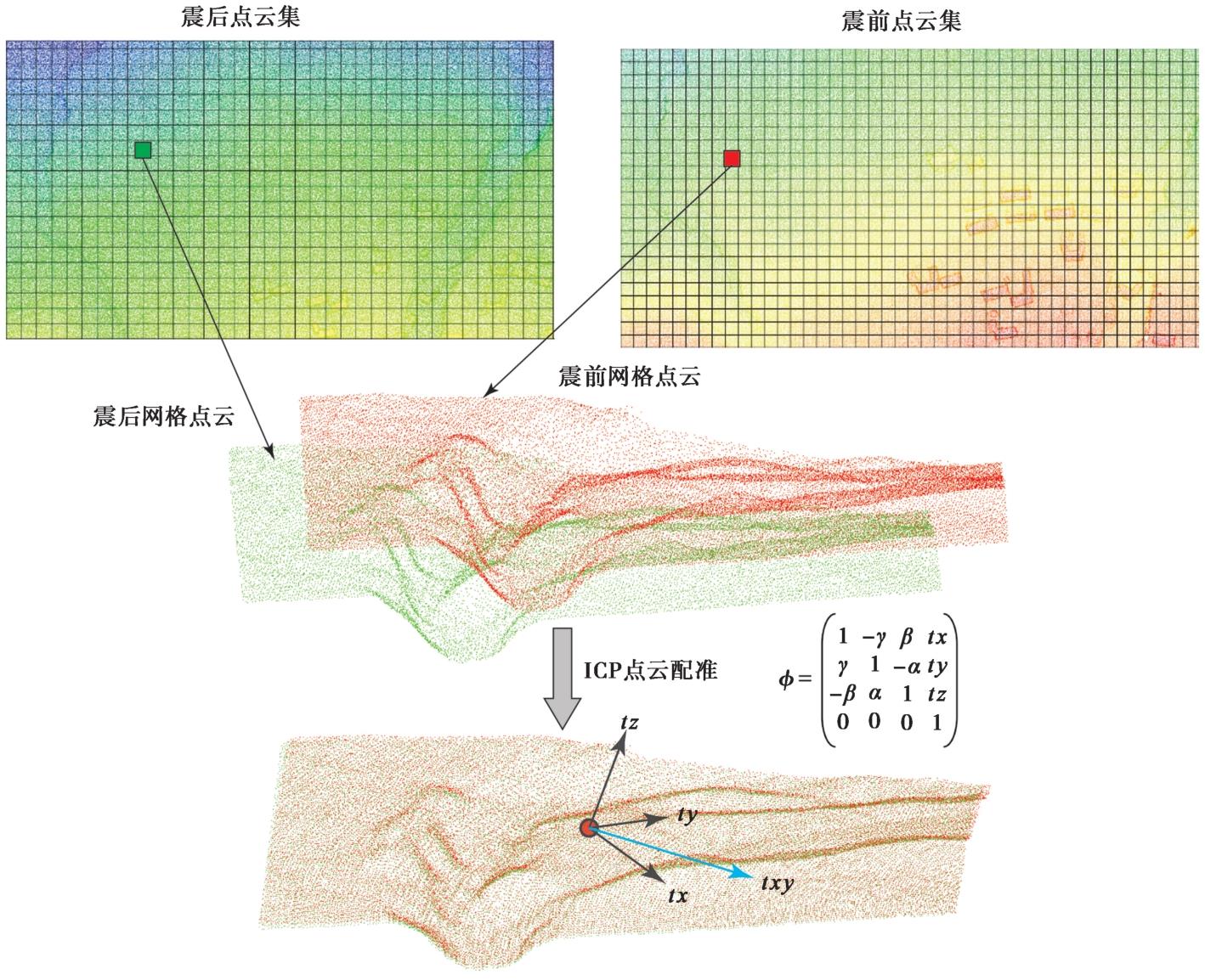
图7 基于震前-震后点云ICP算法提取同震位移矢量示意图
Fig. 7 Schematic diagram of co-seismic displacement vector extraction based on pre-earthquake-post-earthquake point cloud ICP algorithm.
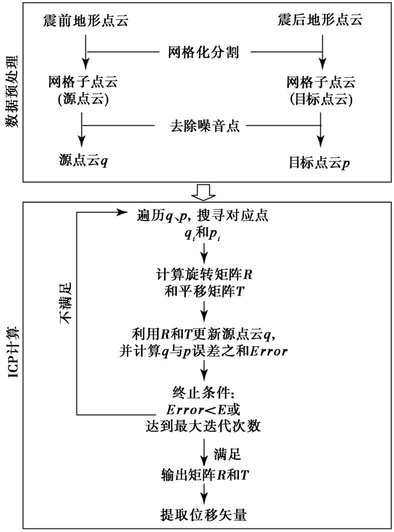
图8 ICP算法提取同震位移矢量技术流程图
Fig. 8 Technical flow chart of ICP algorithm to extract coseismic displacements.
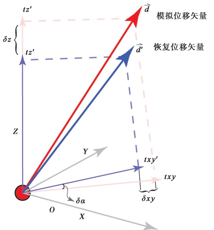
图9 网格中心模拟位移矢量 d - ⇀与恢复位移矢量 d ' ⇀比较示意图 红色线代表模拟位移矢量, 浅红色为垂直和水平位移量; 蓝色线代表恢复位移矢量, 浅蓝色为垂直和水平位移量
Fig. 9 Comparison between simulated displacement d - ⇀ and recovered displacement d ' ⇀ in the center of grid.
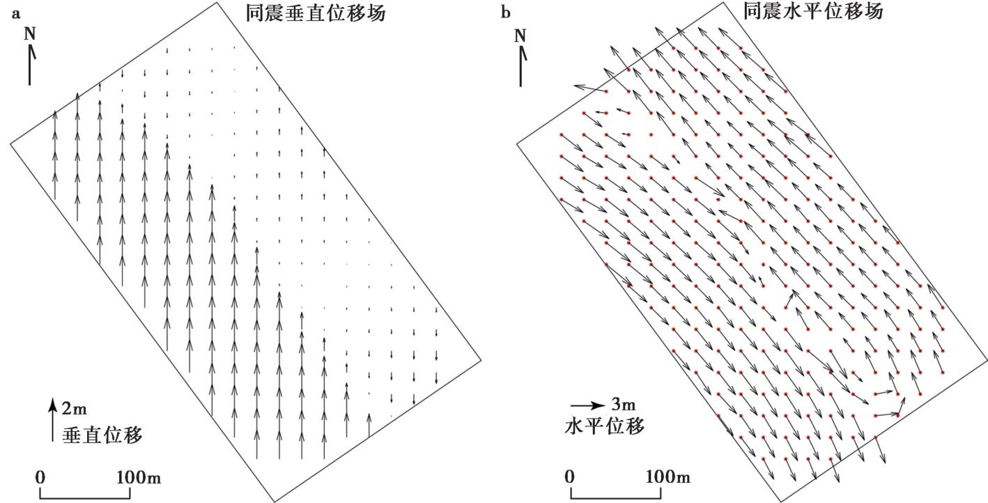
图10 100m×100m网格条件下ICP提取同震位移场 a 同震垂直位移场; b 同震水平位移场
Fig. 10 ICP extraction of coseismic displacement field under 100m×100m grid.
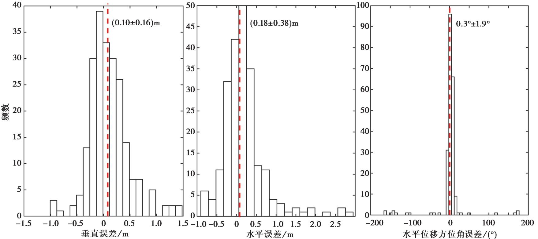
图11 100m×100m网格恢复位移场的误差直方图
Fig. 11 Error histogram of the displacement field of 100m×100m grid restoration.
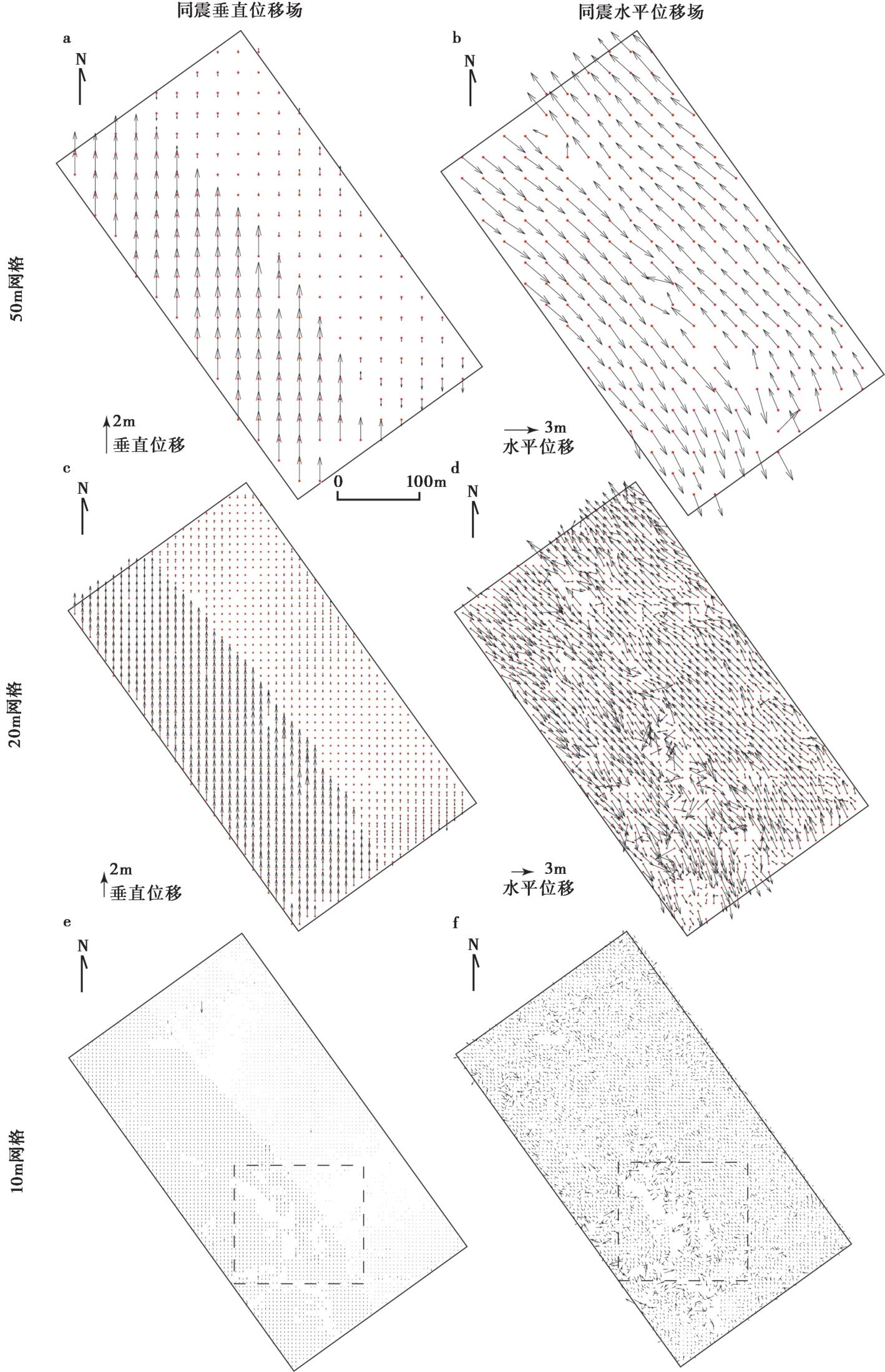
图12 原点云数据在50m、20m和10m网格窗口下恢复同震位移场 图e和f中的黑框代表图14的范围
Fig. 12 The origin cloud data recovers the coseismic displacement field under the 50m, 20m and 10m grids.
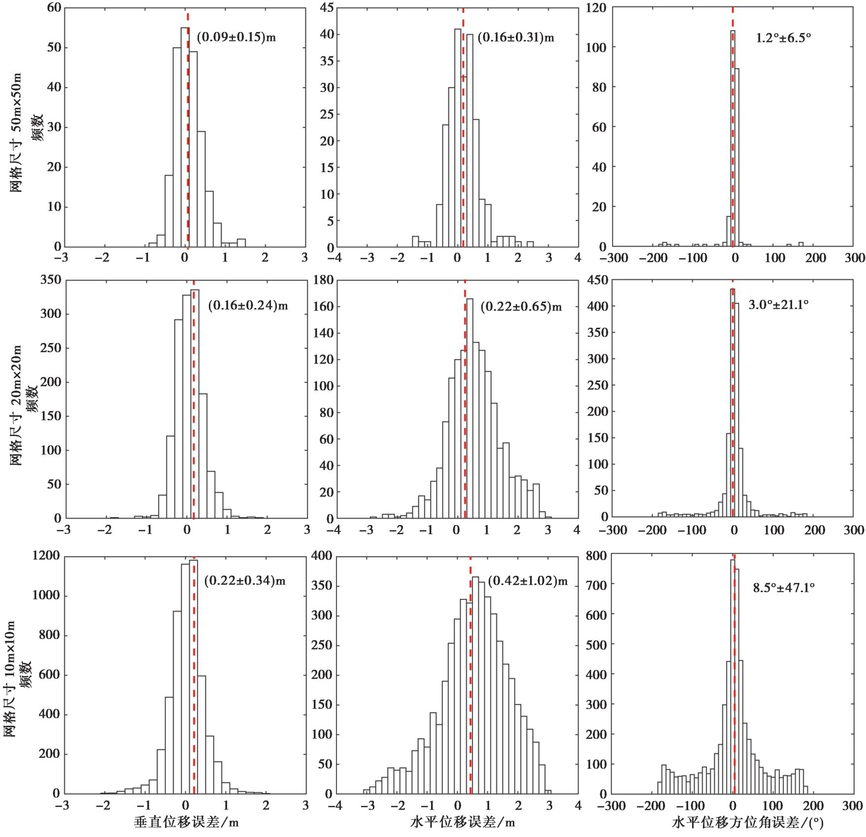
图13 原点云数据在50m、20m和10m尺寸的网格窗口下恢复同震位移场的误差直方图
Fig. 13 Error histogram of coseismic displacement field of origin cloud data under 50m, 20m and 10m grids.
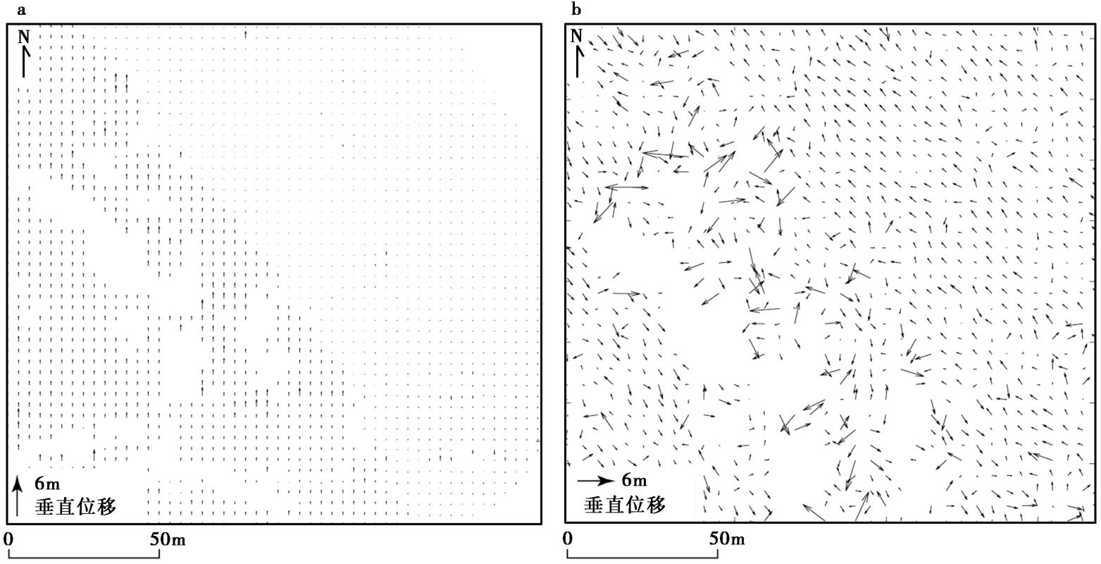
图14 在10m尺寸的网格窗口下恢复同震位移场的局部放大图 图中空白区为新建民房区域, 恢复的位移矢量混乱
Fig. 14 Local magnification of the recovered coseismic displacement field under a 10m grid.
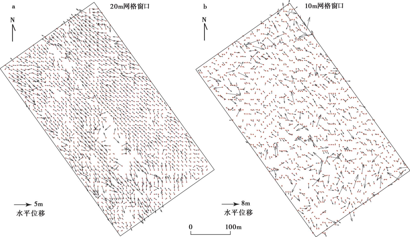
图15 基于密度约为2个/m2的点云在20m和10m尺寸的网格下恢复的水平位移场
Fig. 15 Horizontal displacement field recovered by point cloud density of ~2/m2 under a 20m and 10m grid.
| [1] |
傅志豪, 王鑫, 张景发. 2021. 基于光学遥感影像的 2019 年加利福尼亚 MW7.1 和 MW6.4 双震同震形变测量[J]. 大地测量与地球动力学, 41(5): 506—510.
|
|
|
|
| [2] |
甘洁, 胡俊, 李志伟, 等. 2018. 基于 InSAR 和地应变特征获取 2015 年 MW7.2 Murghab 地震同震三维地表形变场[J]. 中国科学(地球科学), 48(10): 1335—1351.
|
|
|
|
| [3] |
高伟, 何宏林, 孙浩越, 等. 2016. 大凉山断裂带中段普雄断裂晚第四纪古地震.[J]. 地震地质, 38(4): 797—816. doi: 10.3969/j.issn.0253-4967.2016.04.001.
|
|
|
|
| [4] |
何宏林, 池田安隆, 何玉林, 等. 2008. 新生的大凉山断裂带: 鲜水河-小江断裂系中段的裁弯取直[J]. 中国科学(D辑), 38(5): 564—574.
|
|
|
|
| [5] |
李姜一, 周本刚, 李铁明, 等. 2020. 安宁河-则木河断裂带和大凉山断裂带孕震深度研究及其地震危险性[J]. 地球物理学报, 63(10): 3669—3682.
|
|
|
|
| [6] |
苏利娜, 甘卫军, 张勇, 等. 2019. 基于迭代 PCA 的 GPS 时间序列震后形变估计方法和应用[J]. 地球物理学报, 62(3): 940—949.
|
|
|
|
| [7] |
魏占玉,
|
|
|
|
| [8] |
魏占玉, 何宏林, 石峰, 等. 2012. 大凉山断裂带南段滑动速率估计[J]. 地震地质, 34(2): 282—293.
|
|
|
|
| [9] |
闻学泽. 2000. 四川西部鲜水河-安宁河-则木河断裂带的地震破裂分段特征[J]. 地震地质, 22(3): 239—249.
|
|
|
|
| [10] |
武艳强, 黄立人, 陈长云, 等. 2016. 1976 年唐山 MS7.8 地震同震及现今形变特征[J]. 地震学报, 38(4): 609—617.
|
|
|
|
| [11] |
伍毅. 2005. 三维扫描信息获取的深度图像配准算法设计及开发[D]. 杭州: 浙江大学.
|
|
|
|
| [12] |
邹镇宇, 江在森, 武艳强, 等. 2015. 针对一般倾角的走滑/倾滑位移理论公式的改进[J]. 大地测量与地球动力学, 35(3): 460—463.
|
|
|
|
| [13] |
|
| [14] |
|
| [15] |
|
| [16] |
|
| [17] |
|
| [18] |
|
| [19] |
|
| [20] |
|
| [21] |
|
| [22] |
|
| [23] |
|
| [24] |
|
| [25] |
|
| [26] |
|
| [27] |
|
| [28] |
|
| [29] |
|
| [30] |
|
| [31] |
|
| [32] |
|
| [33] |
|
| [34] |
|
| [35] |
|
| [36] |
|
| [37] |
|
| [38] |
|
| [39] |
|
| [40] |
|
| [41] |
|
| [42] |
|
| [43] |
|
| [44] |
|
| [45] |
|
| [46] |
|
| [47] |
|
| [48] |
|
| [49] |
|
| [50] |
|
| [51] |
|
| [52] |
|
| [53] |
|
| [54] |
|
| [1] | 张伟恒, 张东升, 陈杰, 田勤俭, 何万通. 基于地表破裂带宽度统计的活动断层错断变形区范围分析[J]. 地震地质, 2025, 47(1): 345-366. |
| [2] | 缪思钰, 张海江, 古宁, 李俊伦, 谭玉阳, 华思博, 张勇. 基于地震和InSAR联合反演2018年ML5.7兴文地震破裂过程[J]. 地震地质, 2024, 46(2): 397-413. |
| [3] | 吴熙彦, 鲁人齐, 张金玉, 孙晓, 徐芳, 陈桂华. 中国地震科学实验场三维断层模型Web展示原型系统[J]. 地震地质, 2024, 46(1): 35-47. |
| [4] | 黎益仕. 活动断层探测综合标准化[J]. 地震地质, 2023, 45(2): 455-463. |
| [5] | 杨晨艺, 李晓妮, 冯希杰, 黄引弟, 裴跟弟. 秦岭北缘断裂带的重要分支——桃川-户县断层的浅部结构与第四纪活动性[J]. 地震地质, 2023, 45(2): 464-483. |
| [6] | 张浩, 王金艳, 许汉刚, 李丽梅, 蒋新, 赵启光, 顾勤平. 安丘-莒县断裂新沂段的几何结构特征[J]. 地震地质, 2022, 44(6): 1448-1468. |
| [7] | 曹筠, 李彦宝, 冉勇康, 徐锡伟, 马董伟, 张志强. 城市隐伏活动断层避让典型案例分析--以新沂市郯庐断裂带沿线某场地为例[J]. 地震地质, 2022, 44(4): 1071-1085. |
| [8] | 杨晓平, 王萍, 李晓峰, 谢超, 周本刚, 黄雄南. 地形坡度和高程变异系数在识别墨脱活动断裂带中的应用[J]. 地震地质, 2019, 41(2): 419-435. |
| [9] | 吴熙彦, 徐锡伟, 于贵华, 程佳, 陈桂华, 安艳芬, 王启欣. 国家川滇实验场地震地表破裂带分布图编制[J]. 地震地质, 2018, 40(1): 27-41. |
| [10] | 蔡明刚, 鲁人齐, 何宏林, 徐锡伟, 王振南, 李海鸥, 吴熙彦. 水域三维地形与活动断层探测研究——以西昌邛海为例[J]. 地震地质, 2018, 40(1): 204-214. |
| [11] | 闫兵, 贾东. 沿走滑活动断层的基岩河道系统位错——以青藏高原东部为例[J]. 地震地质, 2017, 39(6): 1127-1142. |
| [12] | 邵延秀, 张波, 邹小波, 王爱国, 张帆宇, 袁道阳, 刘兴旺, 何文贵. 采用无人机载LiDAR进行快速地质调查实践[J]. 地震地质, 2017, 39(6): 1185-1197. |
| [13] | 郝海健, 何宏林, 魏占玉, 石峰. 同震地表破裂及活动断层迹线的几何形貌特征[J]. 地震地质, 2017, 39(6): 1267-1282. |
| [14] | 徐锡伟, 郭婷婷, 刘少卓, 于贵华, 陈桂华, 吴熙彦. 活动断层避让相关问题的讨论[J]. 地震地质, 2016, 38(3): 477-502. |
| [15] | 刘兴旺, 袁道阳, 雷中生, 邵延秀. 甘肃酒西盆地发现地震地表破裂带[J]. 地震地质, 2016, 38(3): 605-616. |
| 阅读次数 | ||||||
|
全文 |
|
|||||
|
摘要 |
|
|||||
