地震地质 ›› 2024, Vol. 46 ›› Issue (3): 627-644.DOI: 10.3969/j.issn.0253-4967.2024.03.007
于悦颖1)( ), 李正楷1), 杨云1), 康清清1),*(), 钱佳威2), 王俊菲1), 瞿旻1), 周昱辰1), 李迎春1), 许田1)
收稿日期:2023-05-12
修回日期:2023-10-07
出版日期:2024-06-20
发布日期:2024-07-19
通讯作者:
*康清清, 女, 1983年生, 高级工程师, 主要从事数字地震资料处理和震源机制研究, E-mail: kqq8310@126.com。
作者简介:于悦颖, 女, 1993年生, 2022年于中国科学技术大学获地质工程硕士学位, 工程师, 主要研究方向为地震层析成像和重定位, E-mail: yy_seism@163.com。
基金资助:
YU Yue-ying1)(), LI Zheng-kai1), YANG Yun1), KANG Qing-qing1),*(), QIAN Jia-wei2), WANG Jun-fei1), QU Min1), ZHOU Yu-chen1), LI Ying-chun1), XU Tian1)
Received:2023-05-12
Revised:2023-10-07
Online:2024-06-20
Published:2024-07-19
摘要:
2022年江苏东台接连发生数十次小地震, 其中, 震级最大的 MS3.0 地震导致震中附近震感明显。 为探究该地区近期地震相对活跃的原因, 文中收集了2008—2022年的地震走时资料, 利用双差层析成像方法对苏北盆地的速度结构和地震位置进行了联合反演, 获得了震中区P波三维速度结构和地震精确定位结果, 并结合断裂分布、 震源机制解和当地工业活动等资料, 对地震序列可能的发震机制和发震构造进行了探讨。 结果显示: 1)重定位后, 地震序列总体呈近SN向带状展布, 发震优势深度在11~16km, 与已探明的断裂带缺乏明显联系。 结合震源机制结果推测, 序列下方可能存在NNE-SSW向隐伏构造。 2)震中区下方速度分布具有明显的非均匀性特征, 15km深度处存在纺锤状P波高速异常体, 地震序列的震源位置表现出从该异常体向远处扩散的发震特点。 3)震中区附近现存多处工业活动, 其中五烈—时堰—溱东作业点、 地震序列和深部高速异常三者的位置存在一定的关联性, 且作业时间和发震时间相近。 由此推断, 此次地震序列的发生与深部非均匀速度结构有关, 震中附近的工业活动可能改变了区域应力状态, 导致了能量的释放。
于悦颖, 李正楷, 杨云, 康清清, 钱佳威, 王俊菲, 瞿旻, 周昱辰, 李迎春, 许田. 2022年东台地震序列区域速度结构和精确定位[J]. 地震地质, 2024, 46(3): 627-644.
YU Yue-ying, LI Zheng-kai, YANG Yun, KANG Qing-qing, QIAN Jia-wei, WANG Jun-fei, QU Min, ZHOU Yu-chen, LI Ying-chun, XU Tian. REGIONAL VELOCITY STRUCTURE AND RELOCATION OF THE 2022 DONGTAI EARTHQUAKE SEQUENCE[J]. SEISMOLOGY AND GEOLOGY, 2024, 46(3): 627-644.
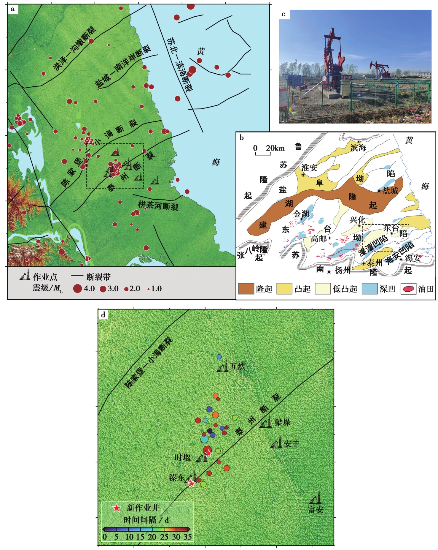
图1 a 2022年苏北盆地内地震事件的分布图; b 苏北盆地的地质构造简图(参考邱旭明等, 2016); c 工作区照片; d 东台地震序列的震中分布图
Fig. 1 Earthquake distribution of Subei Basin in 2022(a), tectonic map of Subei Basin(b) (QIU Xu-ming et al., 2016), on-site picture(c), spatial distribution of Dongtai earthquake sequence(d). 图a、 b中黑色虚线框为地震序列所在区域
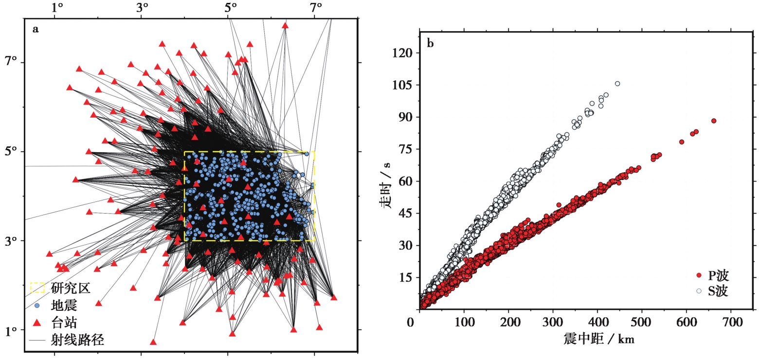
图2 a 地震、 台站、 P波射线分布图; b 时距曲线
Fig. 2 Location of earthquakes, stations and ray paths(a), time-distance curves(b).
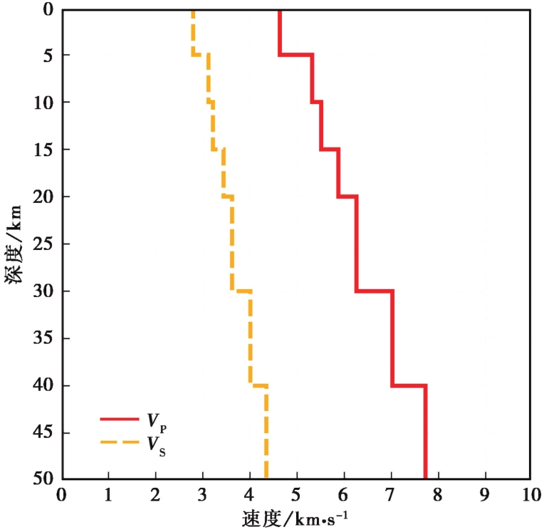
图3 初始一维速度模型
Fig. 3 Initial 1-D velocity model.
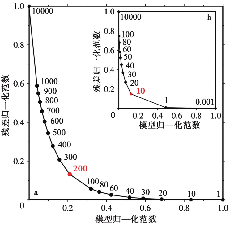
图 4 利用L-curve选择阻尼参数(a)和光滑因子(b)
Fig. 4 Damping(a) and smoothing(b) factors selected through L-curve.
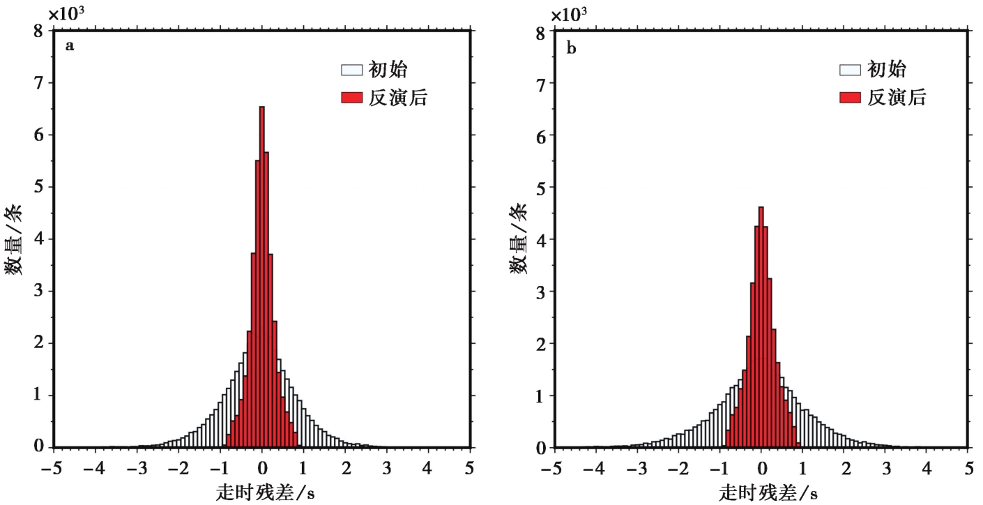
图 5 P波(a)、 S波(b)的走时残差直方图
Fig. 5 Histograms of arrival time residuals for P-wave(a)and S-wave(b).
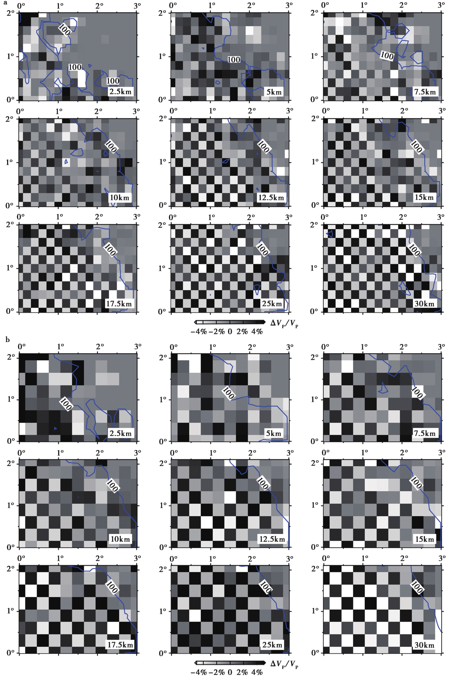
图6 不同深度的VP棋盘格测试结果 a 网格间隔0.2°; b 网格间隔0.3°; 图中蓝色曲线表示DWS等值线
Fig. 6 The checkerboard results for VP at different depths.

图7 地震序列重定位后的震中分布(a)和震源深度(b)分布图 图a中的3口作业井分别用H1、 H2和H3表示
Fig. 7 Distribution of earthquake epicenters(a)and focal depth(b)after relocation.
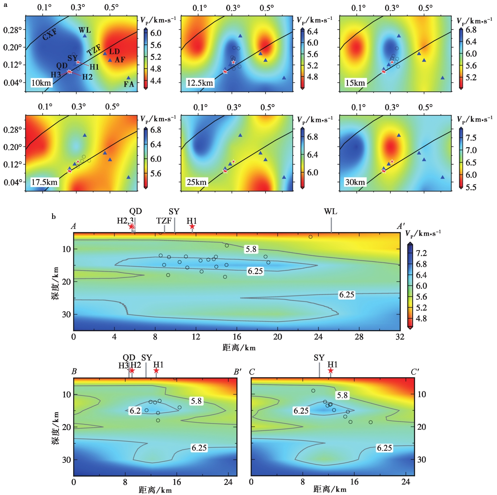
图8 东台地震序列区域水平方向(a)和垂直方向(b)P波速度切片 图中H1、 H2和H3表示3口新井, QD、 SY、 WL、 LD、 AF和FA分别表示溱东、 时堰、 五烈、 梁垛、 安丰和富安作业点。 TZF 泰州断裂; CXF 陈家堡-小海断裂。 黑色圆圈表示地震位置; 蓝色三角形表示作业点位置
Fig. 8 Horizontal velocity slices(a)and vertical cross-sections(b)of VP model.
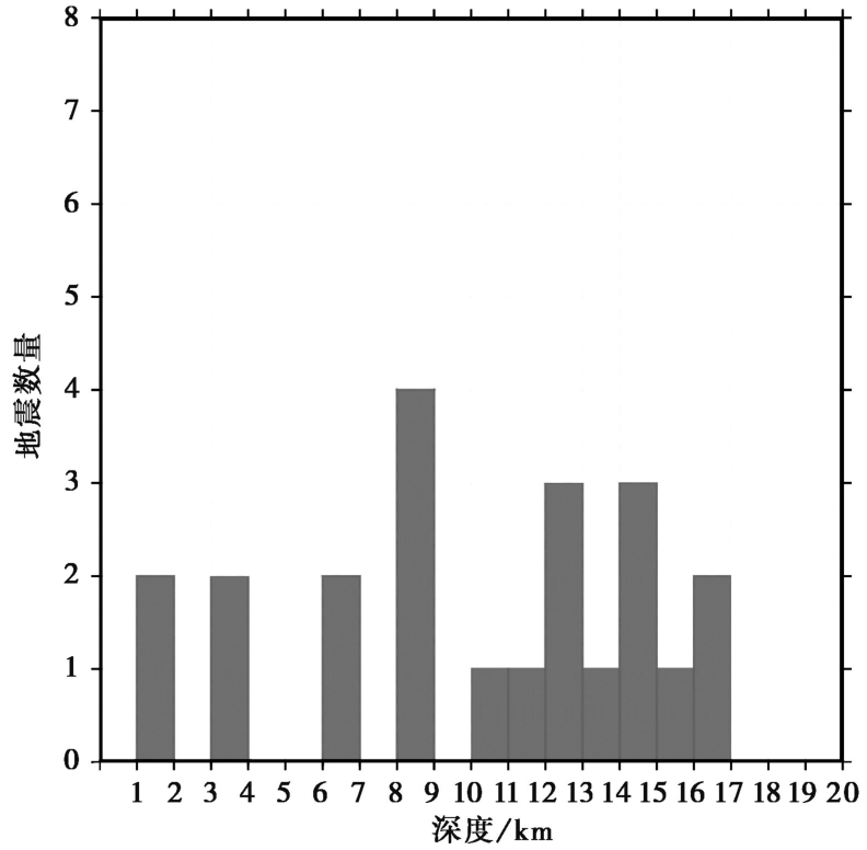
图9 震源深度测试结果图
Fig. 9 Result of focal depth test.

图10 地震序列位置和纺锤状高速异常体三维示意图 a 俯视图; b侧面图。 灰色区域表示纺锤状高速异常体(VP≥6.25km/s)的三维轮廓
Fig. 10 Three-dimensional diagram of the earthquake sequence and high velocity anomaly.
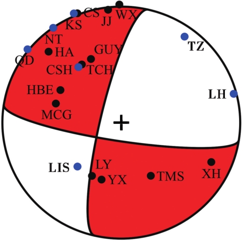
图11 江苏东台 MS3.0 地震的震源机制解 图中黑色实心点表示台站P波初动向上, 蓝色实心点表示台站P波初动向下
Fig. 11 Focal mechanism solution of Jiangsu Dongtai MS3.0 earthquake.
| [1] |
白志明, 王椿镛. 2006. 下扬子地壳P波速度结构: 符离集—奉贤地震测深剖面再解释[J]. 科学通报, 51(21): 2534—2541.
|
|
|
|
| [2] |
陈安定. 2010. 苏北盆地构造特征及箕状断陷形成机理[J]. 石油与天然气地质, 31(2): 140—150.
|
|
|
|
| [3] |
陈艳, 张景发, 姜文亮, 等. 2017. 苏北盆地重力场及地壳结构特征[J]. 地球物理学进展, 32(6): 2295—2303.
|
|
|
|
| [4] |
刁守中, 周焕鹏, 郭爱香. 1987. 山东角07井注(漏)水诱发地震: 震源参数与地震序列特征[J]. 地震地质, 9(3): 84—89.
|
|
|
|
| [5] |
费富安, 刘培华. 1981. 苏北东台坳陷地温与油气的关系[J]. 石油与天然气地质, 2(1): 18—27.
|
|
|
|
| [6] |
顾勤平. 2019. 郯庐断裂带中南段及邻区Pn波和背景噪声层析成像研究[D]. 北京: 中国地震局地球物理研究所:61—64.
|
|
|
|
| [7] |
顾勤平, 丁志峰, 康清清, 等. 2020a. 郯庐断裂带中南段及邻区基于背景噪声的瑞利波群速度层析成像[J]. 地球物理学报, 63(4): 1505—1522.
|
|
|
|
| [8] |
顾勤平, 康清清, 张鹏, 等. 2020b. 郯庐断裂带中南段及邻区Rayleigh波相速度与方位各向异性[J]. 地震地质, 42(5): 1129—1152. doi: 10.3969/j.issn.0253-4967.2020.05.007.
|
|
|
|
| [9] |
何奕成, 范小平, 赵启光, 等. 2021. 郯庐断裂带中南段地壳结构分段特征[J]. 地球物理学报, 64(9): 3164—3178.
|
|
|
|
| [10] |
黄耘, 李清河, 张元生, 等. 2011. 郯庐断裂带鲁苏皖段及邻区地壳速度结构[J]. 地球物理学报, 54(10): 2549—2559.
|
|
|
|
| [11] |
李翠平, 唐茂云, 郭卫英, 等. 2022. 荣昌及周边三维速度结构初步研究[J]. 地震地质, 44(1): 205—219. doi: 10.3969/j.issn.0253-4967.2022.01.013.
|
|
|
|
| [12] |
刘继宝, 潘月斌, 宗合, 等. 2022. 苏北盆地迎来页岩油勘探开发春天[N]. 中国石化报, 2022-08-22( 5).
|
|
|
|
| [13] |
孟亚锋, 姚华建, 王行舟, 等. 2019. 基于背景噪声成像方法研究郯庐断裂带中南段及邻区地壳速度结构与变形特征[J]. 地球物理学报, 62(7): 2490—2509.
|
|
|
|
| [14] |
钱基. 2000. 苏北盆地油气田的形成与分布特征[J]. 石油大学学报(自然科学版), 24(4): 21—25.
|
|
|
|
| [15] |
邱旭明, 钱诗友, 于雯泉, 等. 2016. 苏北盆地“十二五”油气勘探主要成果、 新认识和技术进展[J]. 中国石油勘探, 21(3): 62—73.
|
|
|
|
| [16] |
孙权, 裴顺平, 郭震, 等. 2022. 结构控制的凹凸体对大地震孕育的重要作用[J]. 地球与行星物理论评, 53(2): 138—147.
|
|
|
|
| [17] |
王玺, 陈清华, 朱文斌, 等. 2013. 苏北盆地高邮凹陷边界断裂带构造特征及成因[J]. 大地构造与成矿学, 37(1): 20—28.
|
|
|
|
| [18] |
许忠淮, 汪素云, 黄雨蕊, 等. 1989. 由大量的地震资料推断的我国大陆构造应力场[J]. 地球物理学报, 32(6): 636—647.
|
|
|
|
| [19] |
俞春泉, 陶开, 崔效锋, 等. 2009. 用格点尝试法求解P波初动震源机制解及解的质量评价[J]. 地球物理学报, 52(5): 1402—1411.
|
|
|
|
| [20] |
|
| [21] |
|
| [22] |
|
| [23] |
|
| [24] |
|
| [25] |
|
| [26] |
|
| [27] |
|
| [28] |
|
| [29] |
|
| [30] |
|
| [31] |
|
| [32] |
|
| [33] |
|
| [34] |
|
| [35] |
|
| [36] |
|
| [37] |
|
| [38] |
|
| [39] |
|
| [40] |
|
| [41] |
|
| [42] |
|
| [43] |
|
| [44] |
|
| [45] |
|
| [1] | 曹颖, 钱佳威, 黄江培, 周青云. 云南洱源地区地壳三维精细速度结构成像[J]. 地震地质, 2024, 46(1): 162-183. |
| [2] | 刘亢, 杨婷, 李红光, 房立华, 宋键. 小地震精定位与层析成像揭示的邢台地震区深部构造特征[J]. 地震地质, 2023, 45(6): 1328-1348. |
| [3] | 陈翰林, 王勤彩, 张金川, 刘瑞丰. 四川芦山2022年6月 MS6.1 地震的发震构造及其与2013年4月 MS7.0 地震关系的探讨[J]. 地震地质, 2023, 45(5): 1233-1246. |
| [4] | 李强, 吴建平. 福建地区地壳三维P波速度结构与构造含义[J]. 地震地质, 2023, 45(4): 970-986. |
| [5] | 李翠平, 唐茂云, 郭卫英, 王小龙, 董蕾. 荣昌及周边三维速度结构初步研究[J]. 地震地质, 2022, 44(1): 205-219. |
| [6] | 曹颖, 钱佳威, 黄江培, 张国权, 付虹. 利用时移层析成像方法分析2014年云南景谷MS6.6地震震源区的P波速度变化[J]. 地震地质, 2021, 43(6): 1563-1585. |
| [7] | 李佳妮, 韩竹军, 罗佳宏, 郭鹏. 青藏高原东缘岷山活动地块周缘的地震活动特征与启示[J]. 地震地质, 2021, 43(6): 1459-1484. |
| [8] | 尹欣欣, 蒋长胜, 蔡润, 郭祥云, 姜丛, 王祖东, 邹小波. 云南漾濞地区地壳层析成像与地震精定位[J]. 地震地质, 2021, 43(4): 864-880. |
| [9] | 郭祥云, 尹海权, 汪贞杰, 杨辉. 2021年5月21日云南漾濞M6.4地震序列的矩心矩张量解及动力环境分析[J]. 地震地质, 2021, 43(4): 806-826. |
| [10] | 罗仁昱, 陈继锋, 尹欣欣, 李少华. 青海共和及周边地区的地壳三维速度结构[J]. 地震地质, 2021, 43(1): 232-248. |
| [11] | 李霞, 陈时军, 张正帅, 戴宗辉, 李小晗, 卢仲斌. 山东庙岛群岛地区P波三维速度结构反演与2017年震群的发震构造分析[J]. 地震地质, 2020, 42(5): 1188-1204. |
| [12] | 张娜, 赵翠萍, 李春宏, 周连庆. 基于加密观测的金沙江下游水库区速度结构成像[J]. 地震地质, 2019, 41(6): 1380-1394. |
| [13] | 曲均浩, 王长在, 刘方斌, 周少辉, 郑建常, 李新凤, 张芹. 乳山序列地震分布与震源区速度结构的关系[J]. 地震地质, 2019, 41(1): 99-118. |
| [14] | 李君, 王勤彩, 崔子健, 刘庚, 周琳, 路珍, 周辉. 2017年8月九寨沟M7.0地震序列断层结构及构造应力场特征[J]. 地震地质, 2019, 41(1): 58-71. |
| [15] | 韩晓明, 刘芳, 张帆, 陈立峰, 李娟, 李拴虎, 杨红樱. 鄂尔多斯块体东北缘的P波速度精细结构[J]. 地震地质, 2018, 40(1): 215-231. |
| 阅读次数 | ||||||
|
全文 |
|
|||||
|
摘要 |
|
|||||
