地震地质 ›› 2024, Vol. 46 ›› Issue (3): 570-588.DOI: 10.3969/j.issn.0253-4967.2024.03.004
张浩1)( ), 黄伟亮1),*(), 项闻1,2), 杨虔灝1,3), 刘博1,4)
收稿日期:2023-05-29
修回日期:2023-08-24
出版日期:2024-06-20
发布日期:2024-07-19
通讯作者:
*黄伟亮, 男, 1987年生, 博士, 副教授, 主要从事活动构造与古地震、 新构造与地质灾害等研究, E-mail: huangweiliang@chd.edu.cn。
作者简介:张浩, 男, 1998年生, 现为长安大学地质工程与地质资源在读硕士研究生, 主要研究方向为新构造与地质灾害等研究, E-mail: 1617722977@qq.com。
基金资助:
ZHANG Hao1)(), HUANG Wei-liang1),*(), XIANG Wen1,2), YANG Qian-hao1,3), LIU Bo1,4)
Received:2023-05-29
Revised:2023-08-24
Online:2024-06-20
Published:2024-07-19
摘要:
晚第四纪以来青藏高原东南缘的构造隆升加剧, 导致该区域河流大幅下切并在河谷两侧形成了多层叠置的阶地地貌, 这些地貌面是定量化认识高原隆升过程及气候变化的关键。巴曲河巴塘段地处金沙江中游纵谷地带, 谷底开阔, 河床平缓, 钻探及浅层地震勘探揭示河谷内第四纪地层最厚处为108m, 且至少经历了2次重要的加积阶段, 2次加积事件分别起始于距今318ka和143ka, 对应于MIS 10~9及MIS 6~5的冰川消融阶段。河谷内部发育4级河流阶地, 其中T1—T3为堆积阶地, T4为基座阶地。结合光释光、 14C和宇宙成因核素等年代学方法, 确定T1—T3形成于距今1~5ka之间, T4约形成于距今62ka, 与古气候资料进行对比后发现, T1—T3的下切时间分别与气候由冷向暖的转换有关。而基于阶地的年代和拔河高度计算, 在晚更新世—全新世中期, 巴曲河的下切速率为(1.5±0.3)mm/a; 全新世中期至今, 下切速率增加至(5.5±0.8)mm/a, 增强的下切速率与现今的地壳垂向形变速率匹配, 表明全新世以来地壳隆升的加剧可能是驱动河流快速下切的主要因素。
张浩, 黄伟亮, 项闻, 杨虔灝, 刘博. 晚第四纪以来巴曲河填充-下切及驱动机制[J]. 地震地质, 2024, 46(3): 570-588.
ZHANG Hao, HUANG Wei-liang, XIANG Wen, YANG Qian-hao, LIU Bo. LATE QUATERNARY DEPOSITION AND INCISION SEQUENCES OF THE BAQU RIVER AND THEIR EXPERIMENTAL IMPLICATION[J]. SEISMOLOGY AND GEOLOGY, 2024, 46(3): 570-588.
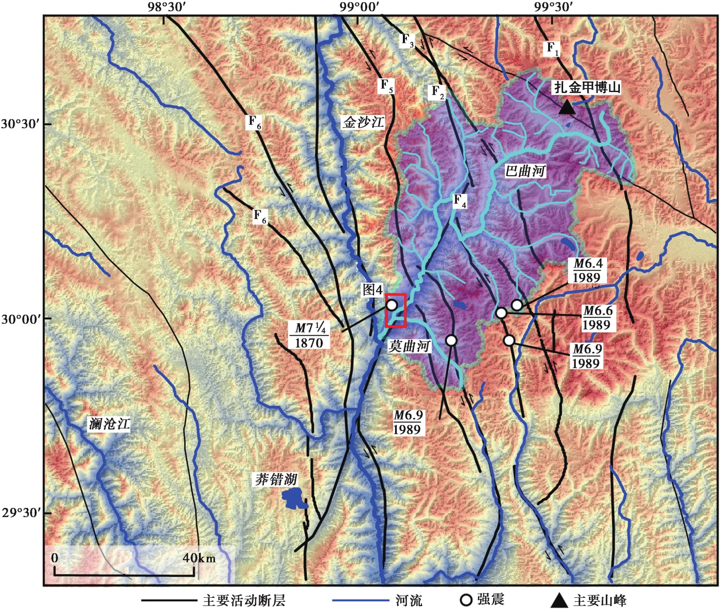
图1 巴曲河流域的地形及活动断层分布 F1—F6均为金沙江断裂带, 分别为: F1拉隆拉玛-阿沙沟断层; F2德登-巴塘-日雨断层; F3岗托-义敦断层; F4巴塘断层; F5波罗-通麦断层; F6字嘎寺-德钦断层
Fig. 1 Distribution of topography and active faults in Baqu River Basin.
| 送样编号 | 测年 阶地 | 238U /Bg·kg-1 | 226Ra /Bg·kg-1 | 232Th /Bg·kg-1 | 40K /Bg·kg-1 | 含水量 /% | 环境剂量率 /Gy·ka-1 | 等效剂量 /Gy | 年龄 /ka |
|---|---|---|---|---|---|---|---|---|---|
| BTT2OSL-1 | T1 | 45.5±10.4 | 25.0±0.8 | 59.7±1.2 | 668.4±22.7 | 10±5 | 4.3±0.2 | 7.1±0.3 | 1.7±0.1 |
| T1OSL-3 | T1 | 41.9±10.7 | 37.1±1.0 | 70.2±1.3 | 679.9±22.8 | 10±5 | 4.7±0.2 | 7.6±0.6 | 1.6±0.2 |
| T2OSL-1 | T2 | 35.4±11.5 | 25.2±0.9 | 54.3±1.2 | 721.6±24.6 | 10±5 | 3.5±0.2 | 10.9±0.4 | 3.1±0.2 |
| T2OSL-2 | T2 | 39.6±10.9 | 31.1±0.9 | 54.6±1.1 | 615.9±21.2 | 10±5 | 3.3±0.2 | 7.6±0.4 | 2.3±0.2 |
表1 巴曲河T1/T2光释光年代及相关参数
Table1 Baqu River T1/T2 quartz luminescence dating results
| 送样编号 | 测年 阶地 | 238U /Bg·kg-1 | 226Ra /Bg·kg-1 | 232Th /Bg·kg-1 | 40K /Bg·kg-1 | 含水量 /% | 环境剂量率 /Gy·ka-1 | 等效剂量 /Gy | 年龄 /ka |
|---|---|---|---|---|---|---|---|---|---|
| BTT2OSL-1 | T1 | 45.5±10.4 | 25.0±0.8 | 59.7±1.2 | 668.4±22.7 | 10±5 | 4.3±0.2 | 7.1±0.3 | 1.7±0.1 |
| T1OSL-3 | T1 | 41.9±10.7 | 37.1±1.0 | 70.2±1.3 | 679.9±22.8 | 10±5 | 4.7±0.2 | 7.6±0.6 | 1.6±0.2 |
| T2OSL-1 | T2 | 35.4±11.5 | 25.2±0.9 | 54.3±1.2 | 721.6±24.6 | 10±5 | 3.5±0.2 | 10.9±0.4 | 3.1±0.2 |
| T2OSL-2 | T2 | 39.6±10.9 | 31.1±0.9 | 54.6±1.1 | 615.9±21.2 | 10±5 | 3.3±0.2 | 7.6±0.4 | 2.3±0.2 |
| 样品编号 | 阶地 | 位置 | 高程 /m | 石英a /g | 9Be载体 /mg | 10Be/9Beb /10-13 | 10Be浓度b /104atoms·g-1 | 1σ总误差c /% | 年龄 /ka | |||||||
|---|---|---|---|---|---|---|---|---|---|---|---|---|---|---|---|---|
| 北纬 /(°) | 东经 /(°) | |||||||||||||||
| BT010BE-3 | T0 | 30.01 | 99.11 | 2584 | 29.26 | 0.25 | 0.29 | 1.65 | 17.1 | |||||||
| BT110BE-4 | T3 | 30.00 | 99.16 | 2590 | 30.13 | 0.24 | 1.70 | 9.29 | 8.7 | 4.5±0.4 | ||||||
| BT110BE-6 | T3 | 30.00 | 99.11 | 2591 | 14.29 | 0.21 | 0.24 | 2.45 | 20.8 | 1.2±0.2 | ||||||
| ZJDT4-1 | T4 | 30.01 | 99.11 | 2687 | 31.23 | 0.26 | 23.6 | 132.511 | 1.9 | 62.32±1.2 | ||||||
表2 巴曲河地貌面10Be年龄结果及其相关参数
Table2 Analytical results of terrestrial cosmogenic nuclide 10Be geochronology
| 样品编号 | 阶地 | 位置 | 高程 /m | 石英a /g | 9Be载体 /mg | 10Be/9Beb /10-13 | 10Be浓度b /104atoms·g-1 | 1σ总误差c /% | 年龄 /ka | |||||||
|---|---|---|---|---|---|---|---|---|---|---|---|---|---|---|---|---|
| 北纬 /(°) | 东经 /(°) | |||||||||||||||
| BT010BE-3 | T0 | 30.01 | 99.11 | 2584 | 29.26 | 0.25 | 0.29 | 1.65 | 17.1 | |||||||
| BT110BE-4 | T3 | 30.00 | 99.16 | 2590 | 30.13 | 0.24 | 1.70 | 9.29 | 8.7 | 4.5±0.4 | ||||||
| BT110BE-6 | T3 | 30.00 | 99.11 | 2591 | 14.29 | 0.21 | 0.24 | 2.45 | 20.8 | 1.2±0.2 | ||||||
| ZJDT4-1 | T4 | 30.01 | 99.11 | 2687 | 31.23 | 0.26 | 23.6 | 132.511 | 1.9 | 62.32±1.2 | ||||||
| 野外编号 | 样品物质 | 深度 /m | U /μg·g-1 | Th /μg·g-1 | K2O /% | 含水量 /% | 等效剂量 /Gy | 剂量率 /Gy·ka-1 | 年龄 /ka |
|---|---|---|---|---|---|---|---|---|---|
| BZK-01 | 中粗砂 | 40.5 | 3.09 | 17.40 | 2.44 | 18 | 558±55 | 3.89 | 143±14 |
| BZK-02 | 中粗砂 | 59.8 | 2.93 | 16.90 | 2.63 | 11 | 674±54 | 3.57 | 189±15 |
| BZK-03 | 中粗砂 | 101.8 | 3.73 | 17.10 | 1.94 | 16 | 1116±70 | 3.51 | 318±20 |
表3 岩心ESR样品测试结果
Table3 Borehole ESR sample test results
| 野外编号 | 样品物质 | 深度 /m | U /μg·g-1 | Th /μg·g-1 | K2O /% | 含水量 /% | 等效剂量 /Gy | 剂量率 /Gy·ka-1 | 年龄 /ka |
|---|---|---|---|---|---|---|---|---|---|
| BZK-01 | 中粗砂 | 40.5 | 3.09 | 17.40 | 2.44 | 18 | 558±55 | 3.89 | 143±14 |
| BZK-02 | 中粗砂 | 59.8 | 2.93 | 16.90 | 2.63 | 11 | 674±54 | 3.57 | 189±15 |
| BZK-03 | 中粗砂 | 101.8 | 3.73 | 17.10 | 1.94 | 16 | 1116±70 | 3.51 | 318±20 |
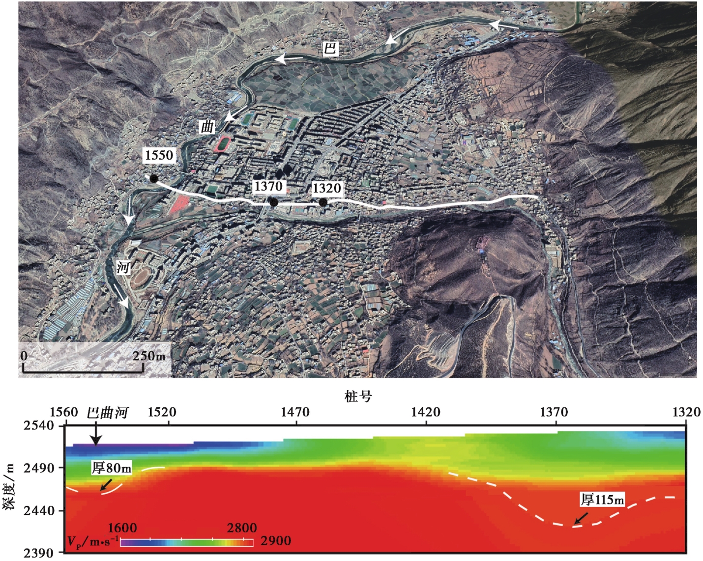
图2 横穿巴曲河谷的纵波速度剖面
Fig. 2 Longitudinal wave velocity profile across the Baqu River Valley.
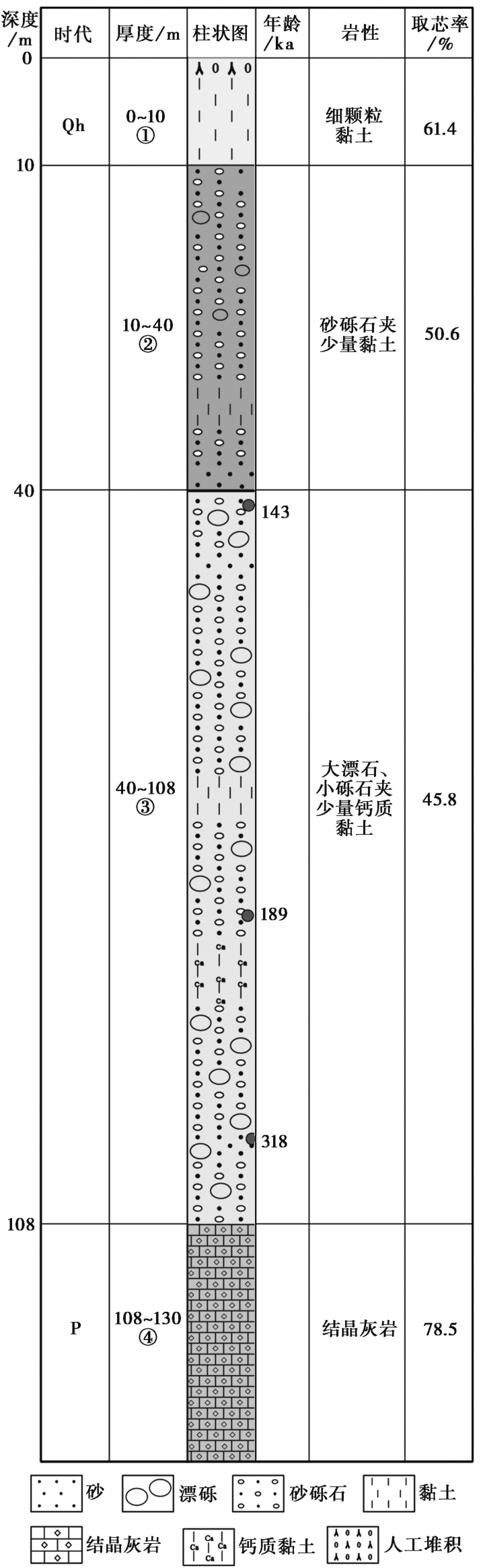
图3 巴曲河谷的钻孔岩心剖面图
Fig. 3 Core profile of Baqu River Valley.
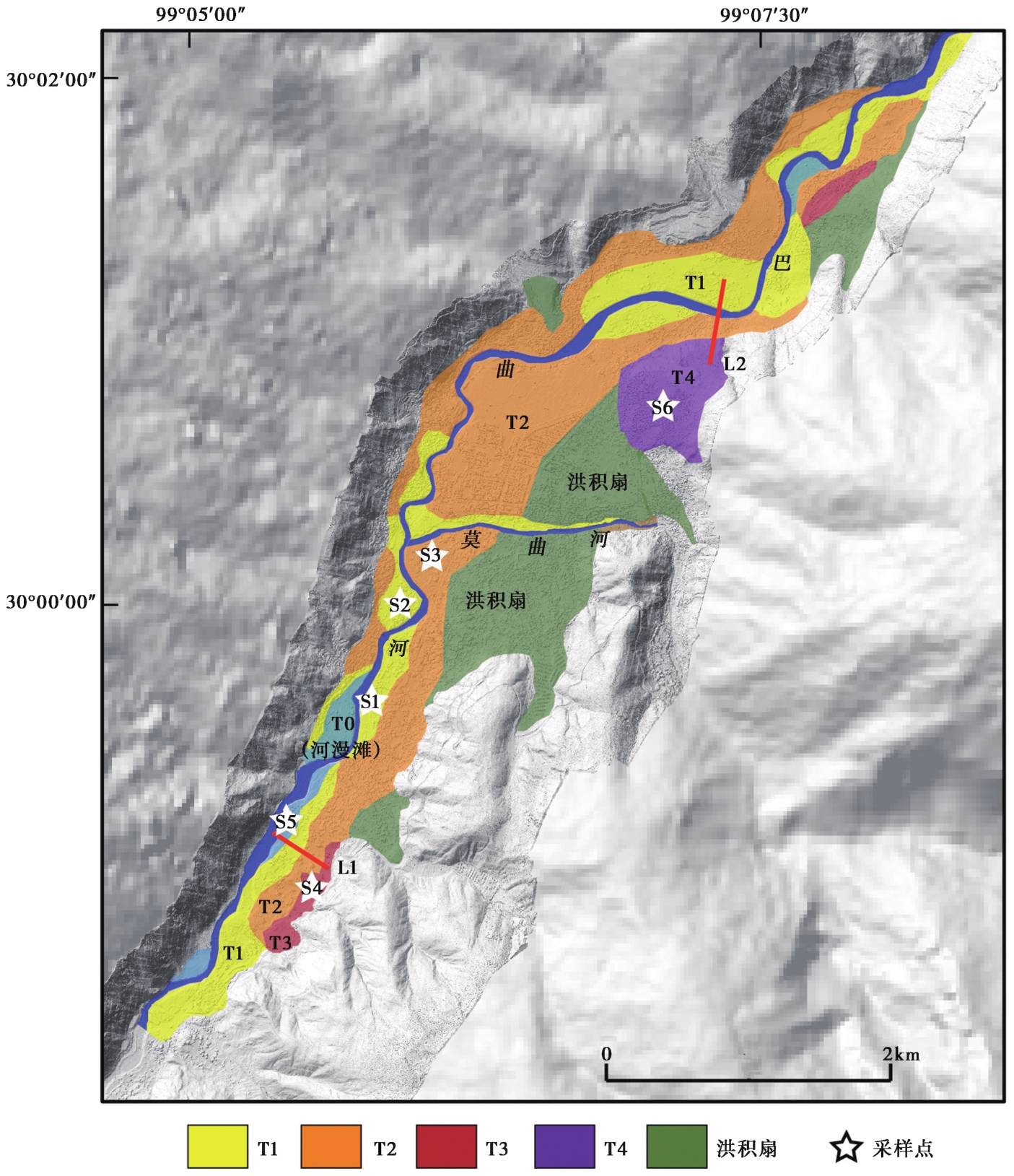
图4 巴曲河巴塘段的阶地空间分布图
Fig. 4 Spatial distribution of terraces in Batang section of Baqu River.
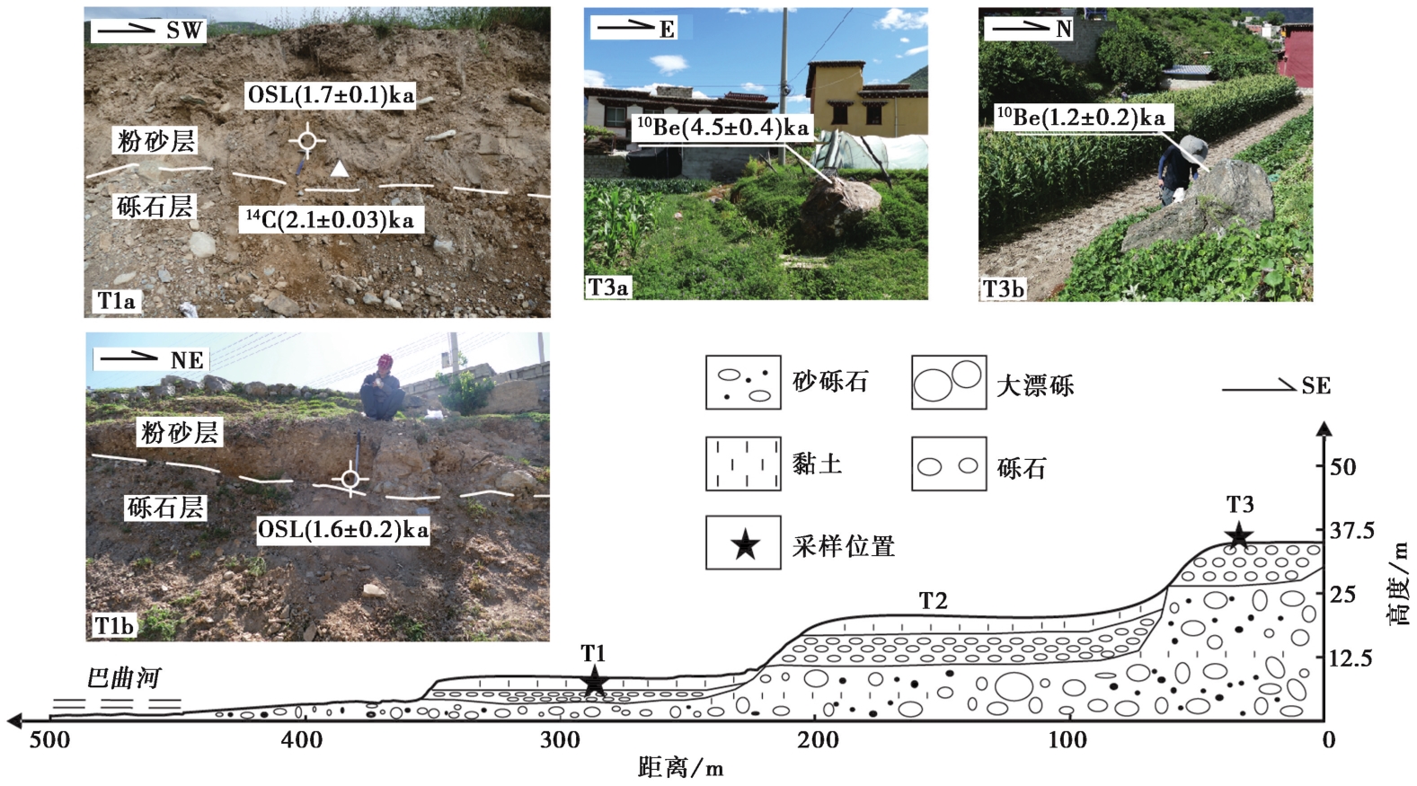
图5 巴塘巴曲河南段茶雪村阶地L1横剖面图
Fig. 5 Cross-section of terrace L1 in Chaxue Village, southern Baqu River, Batang.
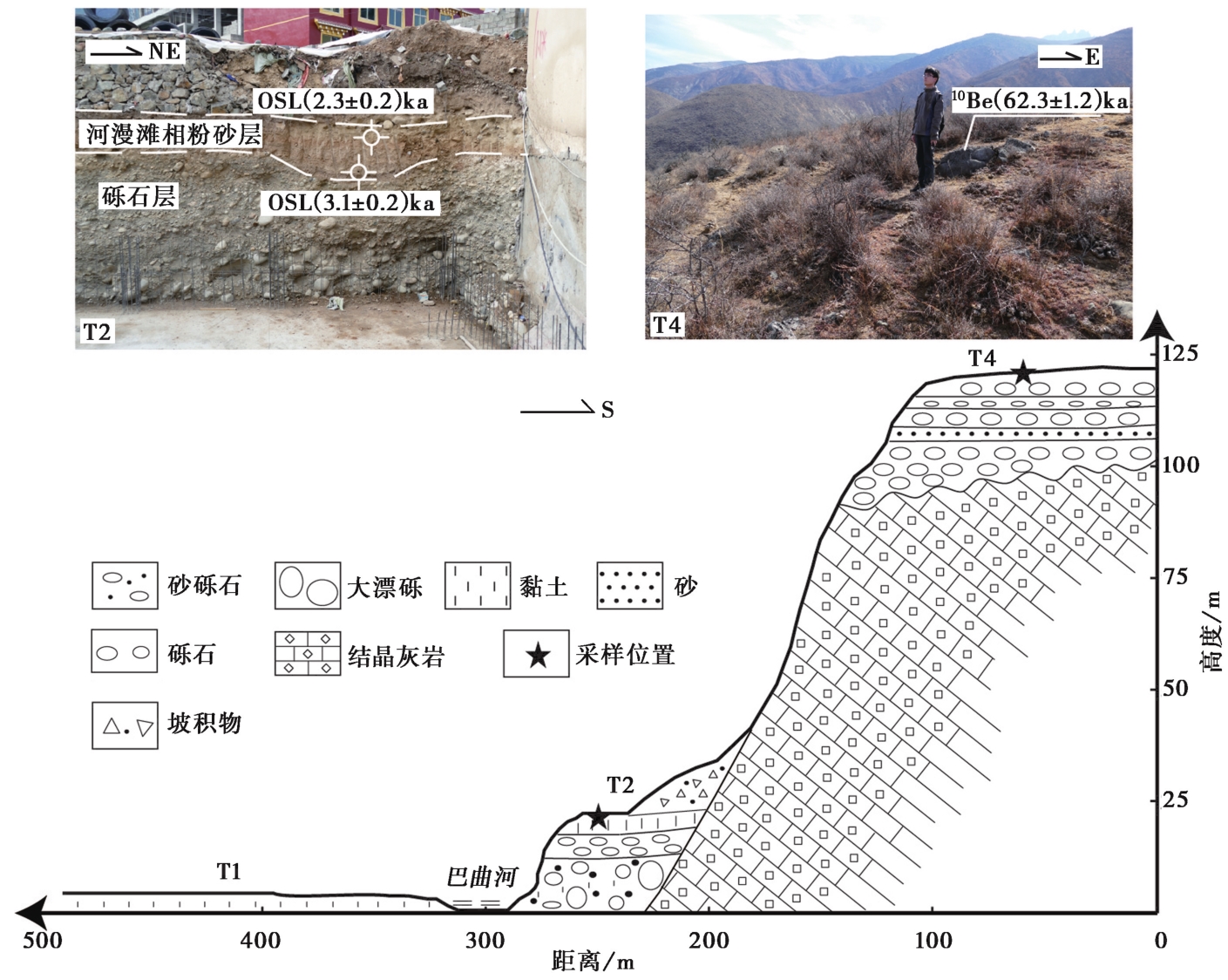
图6 巴塘巴曲河中段扎金顶阶地L2横剖面图
Fig. 6 L2 cross section of Zhajinding terrace in the middle of Baqu River, Batang.
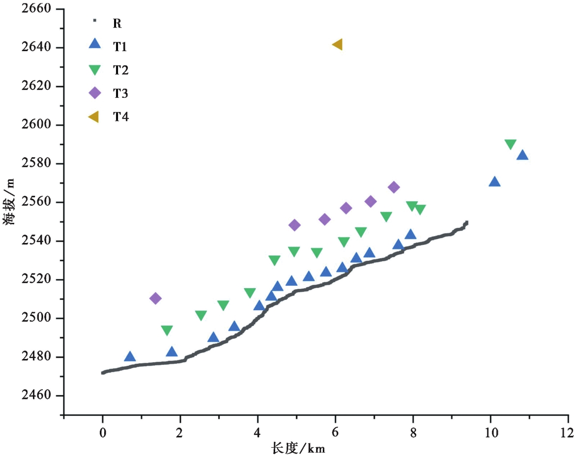
图7 阶地高程的纵剖面图
Fig. 7 Longitudinal profile of terrace.
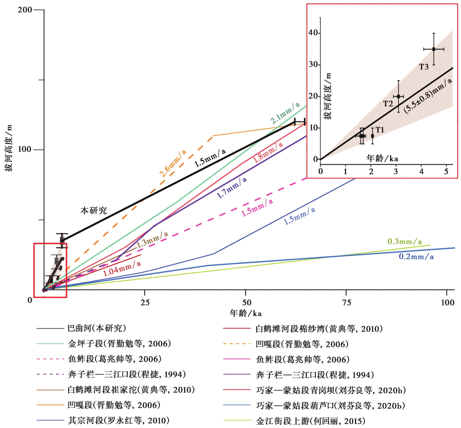
图8 巴曲河下切速率与周边河流的对比 虚线表示推测下切速率
Fig. 8 The incised rate of the Baqu River is compared with the surrounding rivers.
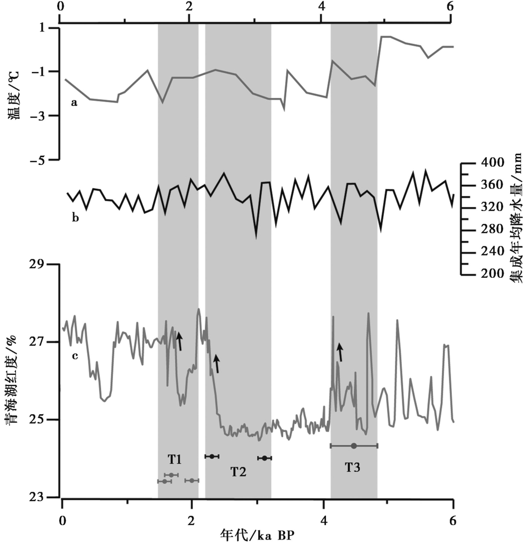
图9 巴曲河下切阶段与气候指标的对比 a 基于花粉的青藏高原东部西门错湖年平均温度重建(Herzschuh et al., 2014); b 青藏高原降雨序列集成重建曲线 (侯光良等, 2019); c青海湖红度变化曲线(Ji et al., 2005)
Fig. 9 Comparison between the incised stage of Baqu River and climate indicators.
| [1] |
白永健, 李明辉, 王东辉, 等. 2014. 金沙江中游巴塘县地质灾害发育特征及成灾规律分析[J]. 中国地质灾害与防治学报, 25(2): 103—109.
|
|
|
|
| [2] |
陈剑平, 李会中. 2016. 金沙江上游快速隆升河段复杂结构岩体灾变特征与机理[J]. 吉林大学学报(地球科学版), 46(4): 1153—1167.
|
|
|
|
| [3] |
程捷. 1994. 金沙江奔子栏—金江街段发育史探讨[J]. 华东地质学院学报, 17(3): 234—241, 253.
|
|
|
|
| [4] |
樊云龙, 王懿萱, 罗光杰, 等. 2022. 晚更新世以来贵州清水江阶地发育及地貌意义[J]. 地理科学, 42(9): 1676—1684.
|
|
|
|
| [5] |
葛兆帅, 刘庆友, 胥勤勉, 等. 2006. 金沙江下段河槽地貌特征与地貌过程[J]. 第四纪研究, 26(3): 421—428.
|
|
|
|
| [6] |
何回丽. 2015. 金沙江金江街段河流阶地序列及形成年代研究[D]. 昆明: 云南师范大学.
|
|
|
|
| [7] |
侯光良, 赖忠平, 刘向军, 等. 2019. 晚冰期以来青藏高原降水序列集成重建[J]. 第四纪研究, 39(3): 615—628.
|
|
|
|
| [8] |
胡小飞, 潘保田, 高红山, 等. 2013. 祁连山东段全新世河流阶地发育及其与气候变化的关系研究[J]. 第四纪研究, 33(4): 723—736.
|
|
|
|
| [9] |
黄典, 杨达源, 李郎平, 等. 2010. 金沙江白鹤滩河段下切速率初步研究[J]. 第四纪研究, 30(5): 872—876.
|
|
|
|
| [10] |
李勇, 曹叔尤, 周荣军, 等. 2005. 晚新生代岷江下蚀速率及其对青藏高原东缘山脉隆升机制和形成时限的定量约束[J]. 地质学报, 79(1): 28—37.
|
|
|
|
| [11] |
刘芬良, 高红山, 李宗盟, 等. 2020a. 金沙江龙街段晚更新世以来的阶地发育与河谷地貌演化[J]. 地球科学进展, 35(4): 431—440.
|
|
|
|
| [12] |
刘芬良, 高红山, 李宗盟, 等. 2020b. 金沙江巧家—蒙姑段的阶地发育与河谷地貌演化[J]. 地理学报, 75(5): 1095—1105.
|
|
|
|
| [13] |
雷传扬, 王波, 刘兆鑫, 等. 2022. 成都平原河流阶地的发育及其对古气候和新构造运动的指示[J]. 沉积与特提斯地质, 44(1): 20—33.
|
|
|
|
| [14] |
罗永红, 王运生, 王自高, 等. 2010. 金沙江其宗河段河谷演化及其工程效应[J]. 山地学报, 28(2): 177—182.
|
|
|
|
| [15] |
谭锡斌, 徐锡伟, 李元希, 等. 2010. 贡嘎山快速隆升的磷灰石裂变径迹证据及其隆升机制讨论[J]. 地球物理学报, 53(8): 1859—1867.
|
|
|
|
| [16] |
王立全, 潘桂棠, 李定谋, 等. 1999. 金沙江弧—盆系时空结构及地史演化[J]. 地质学报, 73(3): 206—218.
|
|
|
|
| [17] |
王庆良, 崔笃信, 王文萍, 等. 2008. 川西地区现今垂直地壳运动研究[J]. 中国科学(D辑), 38(5): 598—610.
|
|
|
|
| [18] |
肖序常, 王军. 1998. 青藏高原构造演化及隆升的简要评述[J]. 地质论评, 44(4): 372—381.
|
|
|
|
| [19] |
胥勤勉, 杨达源, 葛兆帅, 等. 2006. 金沙江三堆子—乌东德河段阶地研究[J]. 地理科学, 26(5): 5609—5615.
|
|
|
|
| [20] |
胥勤勉, 杨达源, 葛兆帅. 2011. 金沙江金坪子堆积体形成过程对青藏高原东缘构造、 气候的响应[J]. 沉积学报, 29(5): 935—945.
|
|
|
|
| [21] |
许志琴, 王宗秀, 侯立玮. 1991. 松潘-甘孜造山带构造研究新进展[J]. 中国地质, (12): 14—16.
|
|
|
|
| [22] |
杨达源, 韩志勇, 葛兆帅, 等. 2008. 金沙江石鼓-宜宾河段的贯通与深切地貌过程的研究[J]. 第四纪研究, 28(4): 564—568.
|
|
|
|
| [23] |
杨源源, 李鹏飞, 郑海刚, 等. 2022. 大别山东麓河流阶地初步研究[J]. 大地测量与地球动力学, 42(12): 1294—1299.
|
|
|
|
| [24] |
张东越, 董有浦, 焦骞骞, 等. 2023. 青藏高原东南缘新生代的三期构造隆升: 来自河流纵剖面分析的证据[J]. 大地构造与成矿学, 47(2): 308—326.
|
|
|
|
| [25] |
张青松, 周耀飞, 陆祥顺, 等. 1991. 现代青藏高原上升速度问题[J]. 科学通报, 36(7): 529—531.
|
|
|
|
| [26] |
周彬, 杨达源, 韩志勇, 等. 2006. 长江三峡河段下切速率研究[J]. 第四纪研究, 26(3): 406—412.
|
|
|
|
| [27] |
周丽琴, 刘维明, 赖忠平, 等. 2019. 河流堰塞的地貌响应[J]. 第四纪研究, 39(2): 366—380.
|
|
|
|
| [28] |
周荣军, 陈国星, 李勇, 等. 2005. 四川西部理塘—巴塘地区的活动断裂与1989年巴塘6.7级震群发震构造研究[J]. 地震地质, 27(1): 31—43.
|
|
|
|
| [29] |
邹波, 王国芝, 邓江红. 2014. 青藏高原东南缘中甸地区上新世快速隆升的磷灰石裂变径迹证据[J]. 成都理工大学学报(自然科学版), 41(2): 227—236.
|
|
|
|
| [30] |
|
| [31] |
|
| [32] |
|
| [33] |
|
| [34] |
|
| [35] |
|
| [36] |
|
| [37] |
|
| [38] |
|
| [39] |
|
| [40] |
|
| [41] |
|
| [42] |
|
| [43] |
|
| [44] |
|
| [45] |
|
| [46] |
|
| [1] | 黄伟亮, 张家乐, 项闻, 杨虔灏. 晚第四纪以来巴塘断裂的活动特征及滑动速率[J]. 地震地质, 2023, 45(6): 1265-1285. |
| [2] | 张秀丽, 熊建国, 张培震, 刘晴日, 姚勇, 钟岳志, 张会平, 李有利. 中更新世晚期以来中条山北麓断层滑动速率研究[J]. 地震地质, 2022, 44(6): 1403-1420. |
| [3] | 李伟, 张世民, 姜大伟, 郜宇. 龙门山南段晚第四纪逆冲活动的河流地貌研究[J]. 地震地质, 2017, 39(6): 1213-1236. |
| [4] | 刘睿, 李安, 张世民, 陈志丹, 郭长辉. 白杨河阶地揭示的北祁连山西段晚第四纪构造变形[J]. 地震地质, 2017, 39(6): 1237-1255. |
| [5] | 田晴映, 郑文俊, 张冬丽, 张逸鹏, 许斌斌, 黄柳婷. 构造活动和气候变化对河流阶地发育的影响——以祁连山北缘洪水坝河和马营河为例[J]. 地震地质, 2017, 39(6): 1283-1296. |
| [6] | 王旭光, 李传友, 吕丽星, 董金元. 龙门山后山断裂中段汶川-茂县断裂的晚第四纪活动性分析[J]. 地震地质, 2017, 39(3): 572-586. |
| [7] | 苏鹏, 田勤俭, 梁朋, 李文巧, 王林. 基于青衣江变形河流阶地研究龙门山断裂带南段的构造活动性[J]. 地震地质, 2016, 38(3): 523-545. |
| [8] | 宋卓沁, 张军龙, 李建军. 基于模糊聚类和空间自相关性的河流阶地自动提取方法 ——以岷江上游漳腊盆地为例[J]. 地震地质, 2014, 36(4): 1029-1042. |
| [9] | 李涛, 陈杰, 肖伟鹏. 滑脱褶皱陡坎的变形特征和运动学模型:以帕米尔-南天山前陆地区明尧勒背斜为例[J]. 地震地质, 2014, 36(3): 677-691. |
| [10] | 李涛, 陈杰. 利用河流阶地限定活动逆断层相关褶皱晚第四纪变形机制和速率:方法与认识[J]. 地震地质, 2014, 36(2): 478-488. |
| [11] | 李涛, 陈杰, 肖伟鹏. 帕米尔-天山对冲带明尧勒背斜西南倾伏端晚第四纪褶皱变形[J]. 地震地质, 2013, 35(2): 234-246. |
| [12] | 杨晓平, 李安, 黄伟亮, 张玲. 天山北麓活动背斜区河流阶地与古地震事件[J]. 地震地质, 2011, 33(4): 739-751. |
| [13] | 刘进峰, 陈杰, 王昌盛. 新疆叶尔羌河上游全新世阶地的释光年代与河流下切速率[J]. 地震地质, 2011, 33(2): 421-429. |
| [14] | 李涛, 陈杰, 肖伟鹏, Burbank D W, 黄明达, Thompson J. 利用变形河流阶地限定帕米尔北缘木什背斜的缩短、隆升和侧向扩展[J]. 地震地质, 2011, 33(2): 308-322. |
| [15] | 杨晓平, 冯希杰, 戈天勇, 宋方敏, 师亚芹, 刘玉法. 龙门山断裂带北段第四纪活动的地质地貌证据[J]. 地震地质, 2008, 30(3): 644-657. |
| 阅读次数 | ||||||
|
全文 |
|
|||||
|
摘要 |
|
|||||
