地震地质 ›› 2024, Vol. 46 ›› Issue (3): 547-569.DOI: 10.3969/j.issn.0253-4967.2024.03.003
李路瑶( ), 丁锐*(), 姜大伟, 张世民
收稿日期:2023-07-17
修回日期:2023-10-12
出版日期:2024-06-20
发布日期:2024-07-19
通讯作者:
*丁锐, 男, 1982年生, 助理研究员, 主要从事活动构造、 构造地貌方面的基础理论与应用研究, E-mail: ruiding@ninhm.ac.cn。
作者简介:李路瑶, 女, 1998年生, 现为应急管理部国家自然灾害防治研究院地球物理学在读硕士研究生, 主要研究高分辨率遥感技术与机载雷达技术在地震断层与地质灾害定量研究中的应用, E-mail: 15271909337@163.com。
基金资助:
LI Lu-yao(), DING Rui*(), JIANG Da-wei, ZHANG Shi-min
Received:2023-07-17
Revised:2023-10-12
Online:2024-06-20
Published:2024-07-19
摘要:
阿尔金断裂带是青藏高原北缘的大型左旋走滑断裂, 其东段与NW走向的祁连山逆冲断裂带斜接。文中基于无人机摄影测量技术(SfM)获得的高分辨率影像数据, 对阿尔金断裂带东段长约127km的段落开展了详细解译, 并对其中9个典型河流阶地位错点进行测量与统计。沿阿尔金断裂带向E, 晚第四纪左旋累积位移总体呈衰减趋势, 且以断裂带东侧NW走向斜接逆冲断裂或逆冲走滑断裂为界, 其累积位错量在同一断裂段内大致相当, 但相邻断裂段之间表现为阶梯状递减, 指示了斜接断裂的构造转换关系及可能的地震破裂分段作用, 为阿尔金断裂带活动性分段研究与潜在发震能力评价提供了依据。
李路瑶, 丁锐, 姜大伟, 张世民. 阿尔金断裂东段的河流阶地累积位错[J]. 地震地质, 2024, 46(3): 547-569.
LI Lu-yao, DING Rui, JIANG Da-wei, ZHANG Shi-min. CUMULATIVE DISLOCATIONS OF RIVER TERRACES IN THE EASTERN SEGMENT OF THE ALTYN TAGH FAULT[J]. SEISMOLOGY AND GEOLOGY, 2024, 46(3): 547-569.
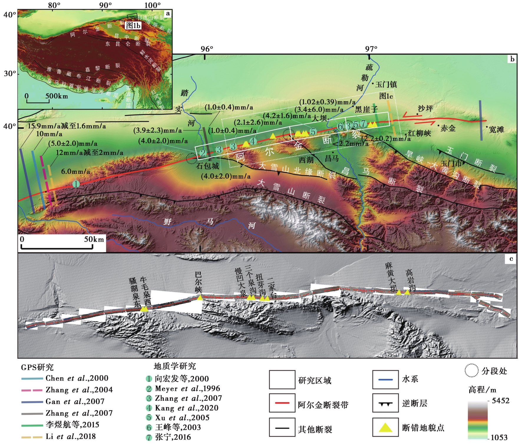
图1 阿尔金断裂带东段及邻区主要断裂分布图 a 青藏高原周缘主要活动断裂分布图, 红色粗线条代表阿尔金断裂带, 黑色粗线为其他断裂; b 阿尔金断裂带东段及邻区主要断裂分布图, 地形底图源于地理空间数据云提供的共享数据SRTMDEM数据(分辨率为90m), 黄色三角形为本文河流阶地研究点, 白色条带状矩形代表无人机影像数据覆盖范围, 对研究区域阿尔金断裂带东段的几何分段分别为梧桐沟—石盆湾段、 石盆湾—红柳沟段、 红柳沟—沙坪段; c 通过无人机摄影测量技术得到的高分辨率地形数据展布, 断错地貌点具体分布如图所示
Fig. 1 Distribution of main faults in the eastern section and adjacent areas of Altyn fault zone.
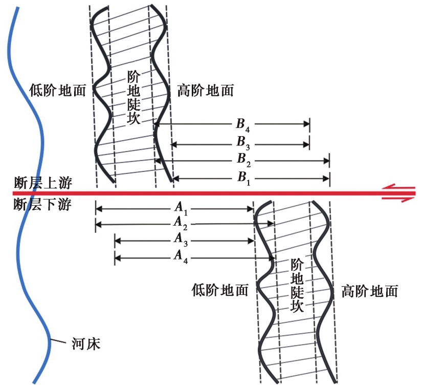
图2 阶地陡坎位错测量示意图
Fig. 2 Schematic diagram for measuring the offset distance of terrace riser.
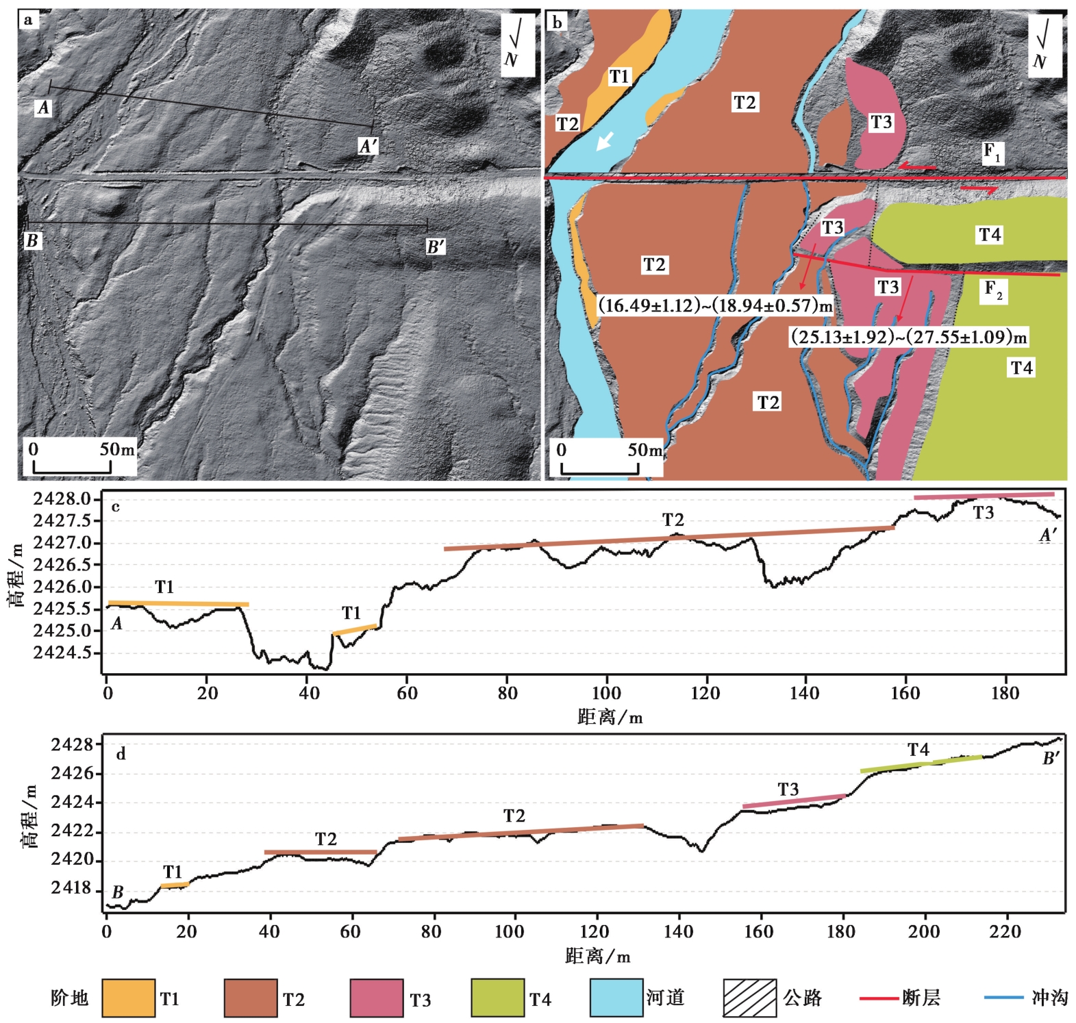
图3 骚湖泉东地貌解译图 a 骚湖泉东的高精度DEM; b 骚湖泉东的地貌解译; c 图a中的AA'剖面线; d.图a中的BB'剖面线
Fig. 3 Geomorphologic interpretation of Saohuquan East.
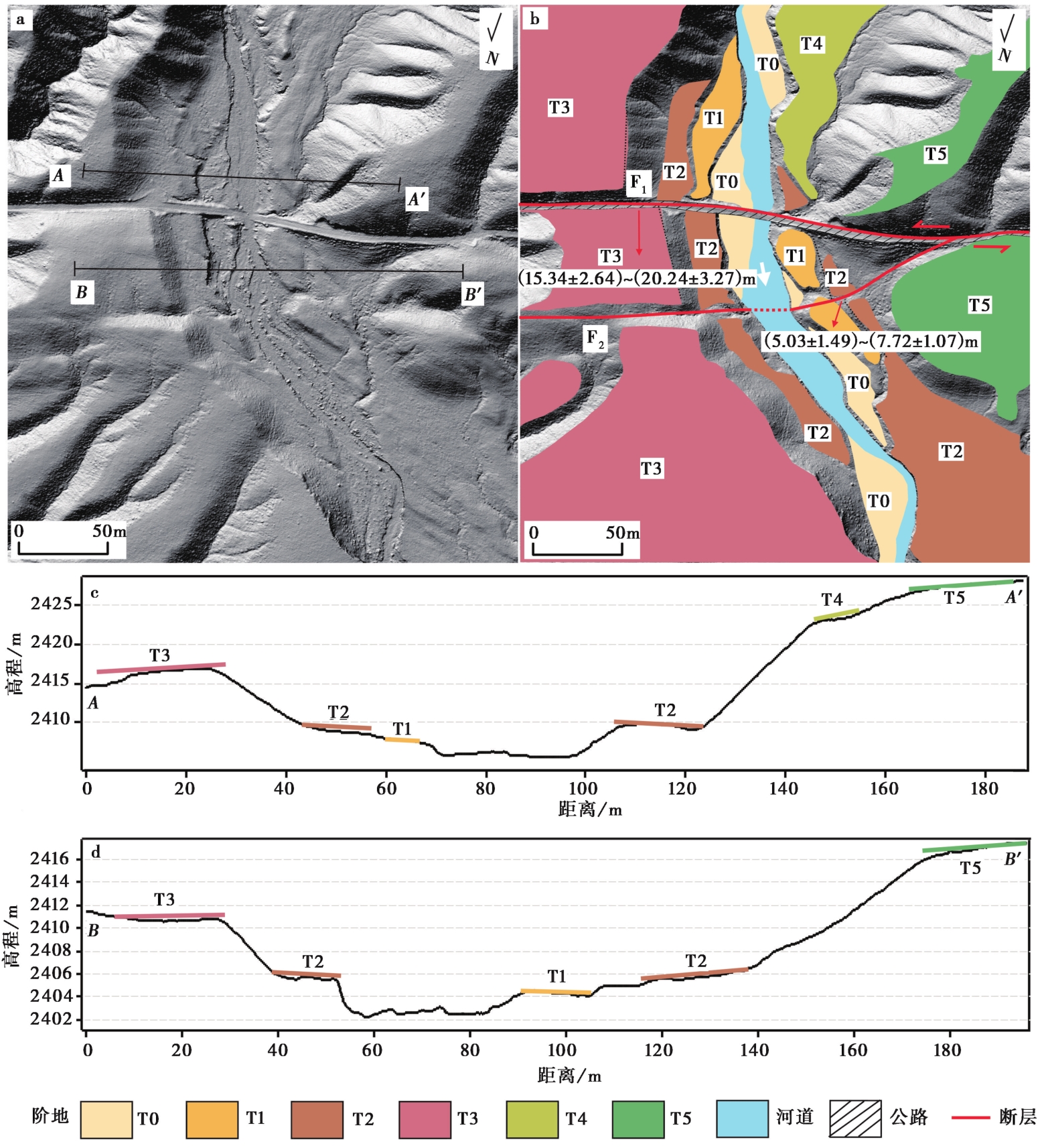
图4 牛毛泉西地貌解译图 a 牛毛泉西的高精度DEM; b 牛毛泉西的地貌解译; c 图a中的AA'剖面线; d 图a中的BB'剖面线
Fig. 4 Geomorphologic interpretation of Niumaoquan West.
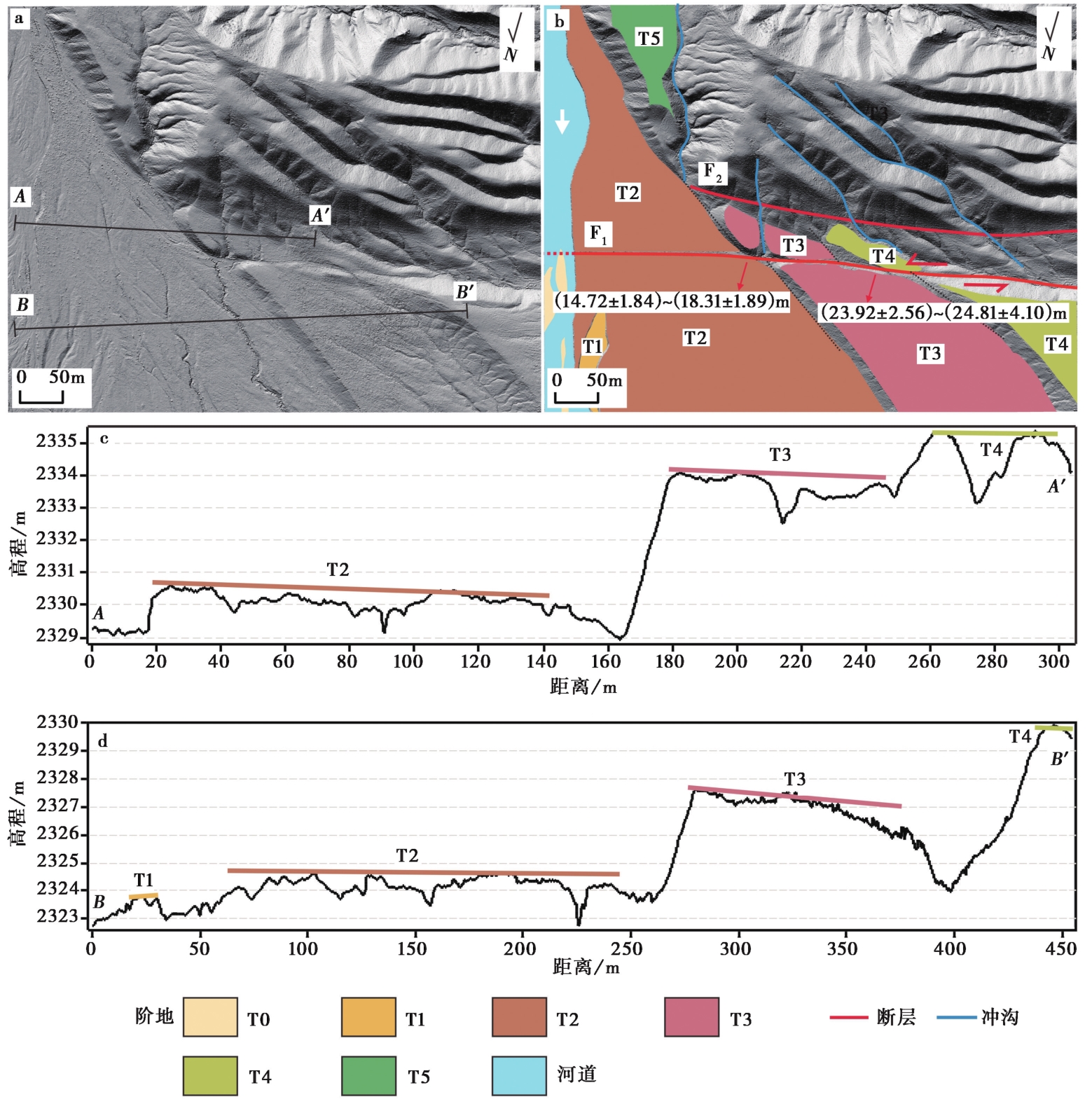
图5 巴尔峡地貌解译图 a 巴尔峡的高精度DEM; b 巴尔峡的地貌解译; c 图a中的AA'剖面线; d 图a的中BB'剖面线
Fig. 5 Geomorphologic interpretation of Bar Gorge.
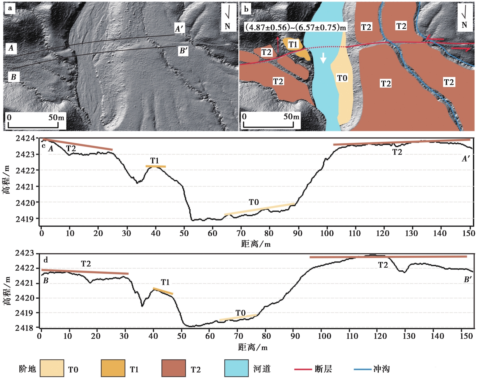
图6 阳凹大泉东地貌解译图 a 阳凹大泉东的高精度DEM; b 阳凹大泉东的地貌解译; c 图a中的AA'剖面线; d 图a中的BB'剖面线
Fig. 6 Geomorphologic interpretation of Yang’aodaquan East.
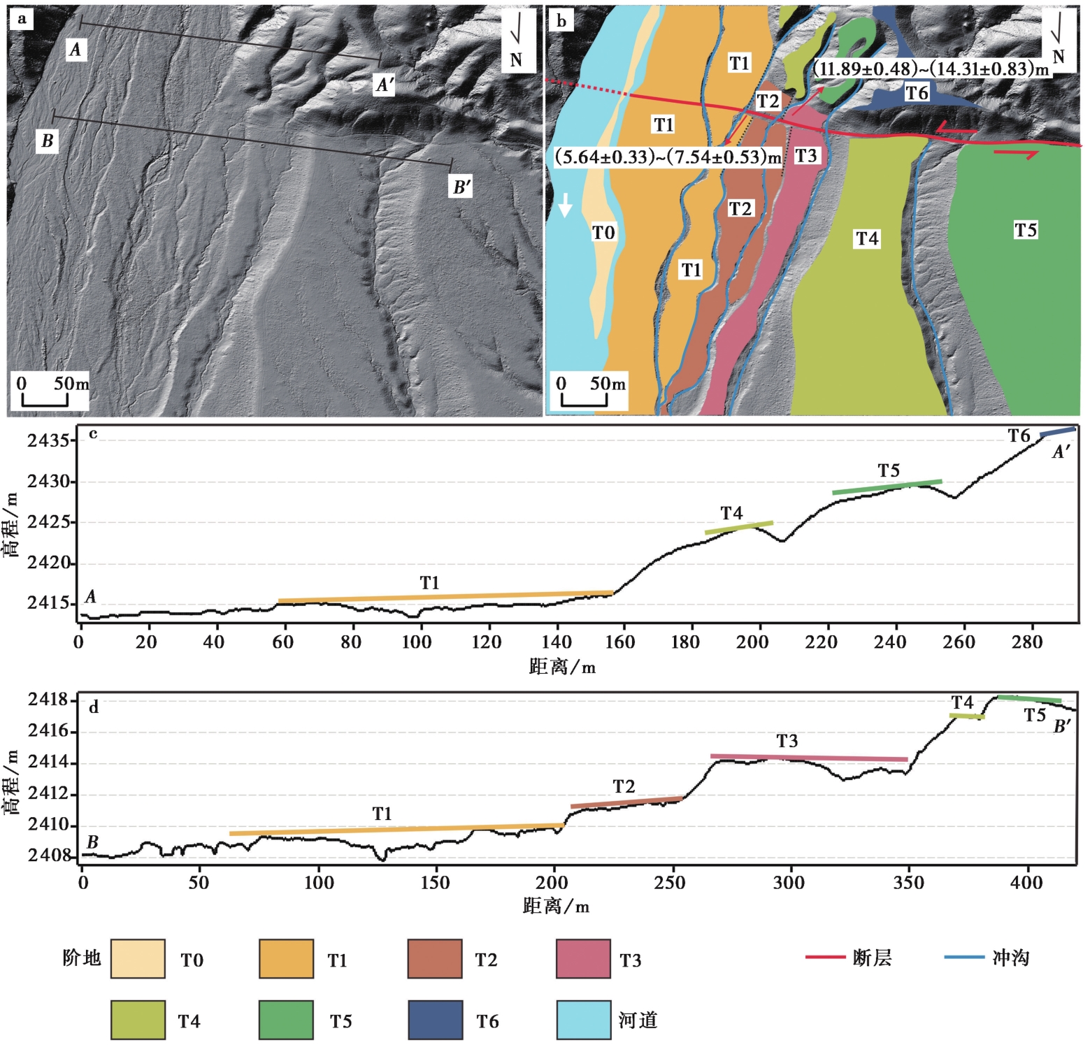
图7 三个泉沟地貌解译图 a 三个泉沟的高精度DEM; b 三个泉沟的地貌解译; c 图a中的AA'剖面线; d 图a中的BB'剖面线
Fig. 7 Geomorphologic interpretation of Sangequangou.

图8 扭芽沟地貌解译图 a 扭芽沟的高精度DEM; b 扭芽沟的地貌解译; c 图a中的AA'剖面线; d 图a中的BB'剖面线
Fig. 8 Geomorphologic interpretation of Niuyagou.

图9 二家台地貌解译图 a 二家台的高精度DEM; b 二家台的地貌解译; c 图a中的AA'剖面线; d 图a中的BB'剖面线
Fig. 9 Geomorphologic interpretation of Erjiatai.
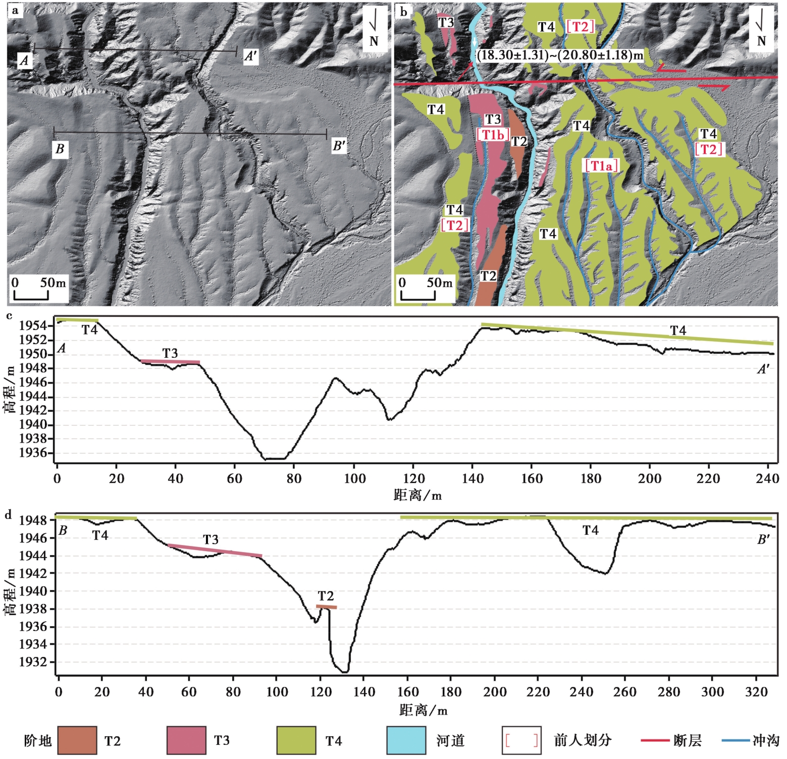
图10 麻黄河坝地貌解译图 a 麻黄河坝的高精度DEM; b 麻黄河坝的地貌解译; c 图a中的AA'剖面线; d 图a中的BB'剖面线
Fig. 10 Geomorphologic interpretation of Mahuang River Dam.

图11 高岩沟地貌解译图 a 高岩沟的高精度DEM; b 高岩沟的地貌解译; c 图a中的AA'剖面线; d.图a中的BB'剖面线
Fig. 11 Geomorphologic interpretation of Gaoyangou.
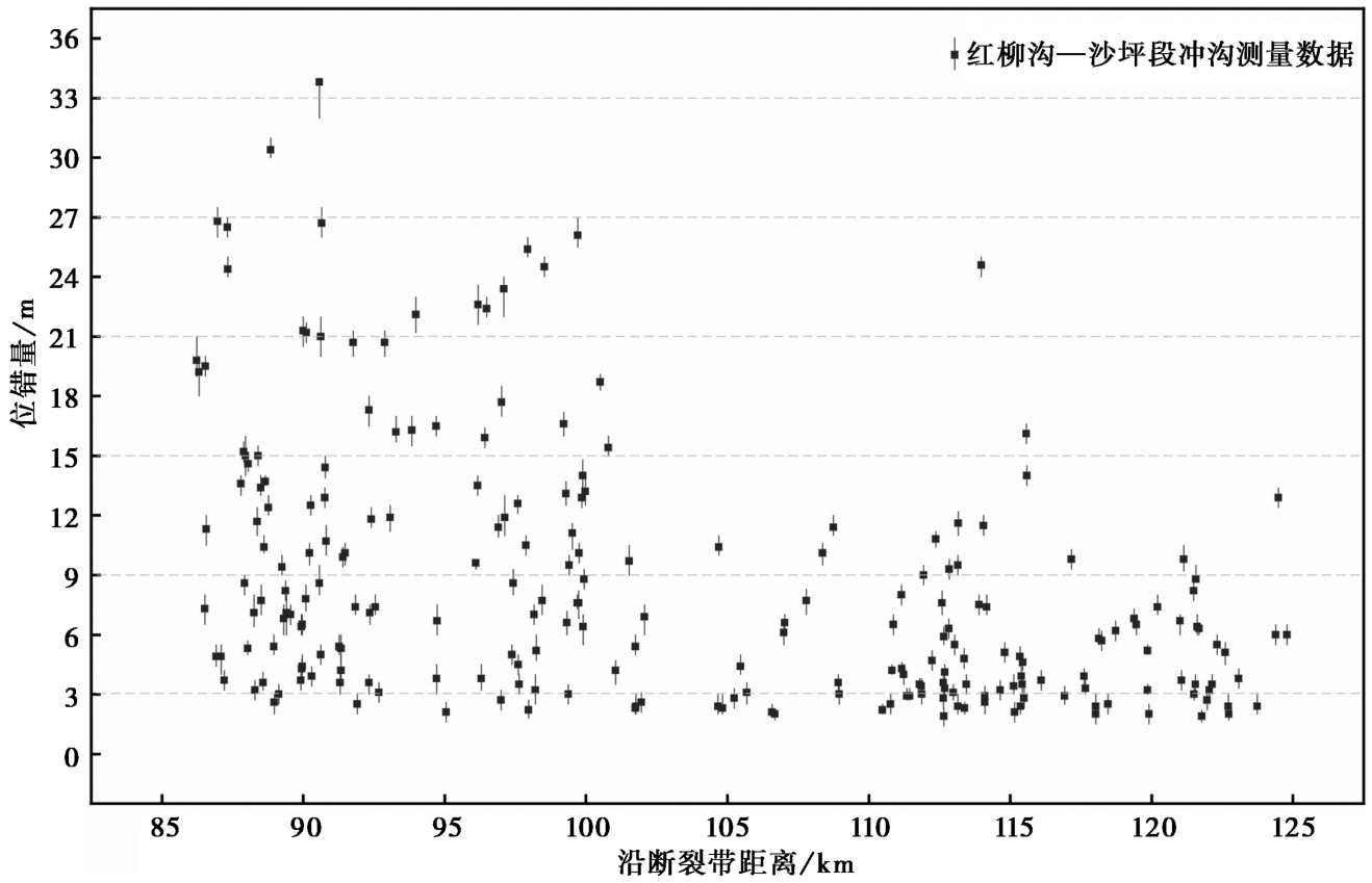
图12 红柳沟—沙坪段冲沟位错量分布图
Fig. 12 Distribution map of channel offset in the Hongliugou Shaping section.
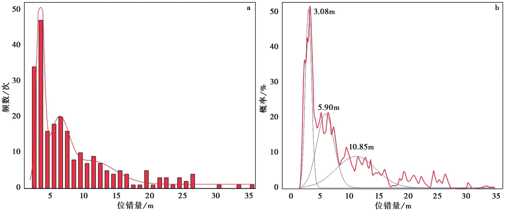
图13 a 冲沟位移频率分布直方图; b 累积位移概率分布图
Fig. 13 Channel offset frequency distribution histogram (a) and cumulative offset probability density distribution map (b).
| 断裂段 | 梧桐沟—石盆湾段 | 石盆湾—红柳沟段 | 红柳沟—沙坪段 | ||||||
|---|---|---|---|---|---|---|---|---|---|
| 测量点 | 骚湖泉东 | 牛毛泉西 | 巴尔峡 | 阳凹大泉东 | 三个泉沟 | 扭芽沟 | 二家台 | 麻黄大坝 | 高岩沟 |
| T0/T1 | 2.25±0.42 ~ 2.95±0.50 | ||||||||
| T1/T2 | 5.03±1.49 ~ 7.72±1.07 | 4.87±0.56 ~ 6.57±0.75 | 5.64±0.33 ~ 7.54±0.53 | 6.61±0.23 ~ 7.51±0.29 | 6.81±0.90 ~ 7.33±2.07 | 4.99±0.26 ~ 5.86±0.40 | |||
| T2/T3 | 16.49±1.12 ~ 18.94±0.57 | 15.34±2.64 ~ 20.24±3.27 | 14.72±1.84 ~ 18.31±1.89 | 11.89±0.48 ~ 14.31±0.83 | 10.26±1.02 ~ 13.11±1.01 | 9.48±1.26 ~ 11.26±1.03 | |||
| T3/T4 | 25.13±1.92 ~ 27.55±1.09 | 23.92±2.56 ~ 24.81±4.10 | 18.30±1.31 ~ 20.80±1.18 | 17.18±1.56 ~ 22.94±1.12 | |||||
| T4/T5 | 54.46±2.36 ~ 67.77±1.19 | ||||||||
表1 阿尔金断裂东段各测量点阶地陡坎位错量表(单位: m)
Table1 Measurement Results of Terrace Steep Slope dislocations at various observation points in the eastern section of the Altyn Tagh Fault(unit: m)
| 断裂段 | 梧桐沟—石盆湾段 | 石盆湾—红柳沟段 | 红柳沟—沙坪段 | ||||||
|---|---|---|---|---|---|---|---|---|---|
| 测量点 | 骚湖泉东 | 牛毛泉西 | 巴尔峡 | 阳凹大泉东 | 三个泉沟 | 扭芽沟 | 二家台 | 麻黄大坝 | 高岩沟 |
| T0/T1 | 2.25±0.42 ~ 2.95±0.50 | ||||||||
| T1/T2 | 5.03±1.49 ~ 7.72±1.07 | 4.87±0.56 ~ 6.57±0.75 | 5.64±0.33 ~ 7.54±0.53 | 6.61±0.23 ~ 7.51±0.29 | 6.81±0.90 ~ 7.33±2.07 | 4.99±0.26 ~ 5.86±0.40 | |||
| T2/T3 | 16.49±1.12 ~ 18.94±0.57 | 15.34±2.64 ~ 20.24±3.27 | 14.72±1.84 ~ 18.31±1.89 | 11.89±0.48 ~ 14.31±0.83 | 10.26±1.02 ~ 13.11±1.01 | 9.48±1.26 ~ 11.26±1.03 | |||
| T3/T4 | 25.13±1.92 ~ 27.55±1.09 | 23.92±2.56 ~ 24.81±4.10 | 18.30±1.31 ~ 20.80±1.18 | 17.18±1.56 ~ 22.94±1.12 | |||||
| T4/T5 | 54.46±2.36 ~ 67.77±1.19 | ||||||||
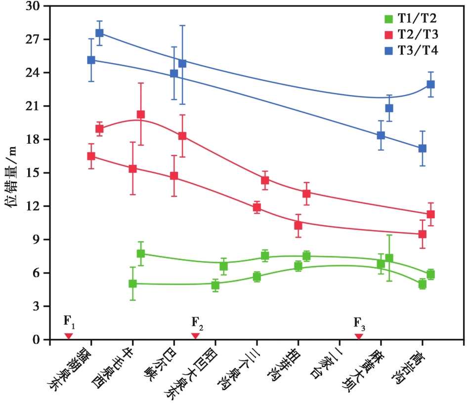
图14 阿尔金断裂东段各测量点T1/T2、 T2/T3、 T3/T4的位错量变化趋势图 绿色、 红色、 蓝色实线分别代表T1/T2、 T2/T3、 T3/T4阶地陡坎的上、 下边缘位错量变化趋势范围, 同级阶地陡坎位错量高值与低值上下误差棒范围存在重叠而错开显示。 F1大雪山北缘断裂; F2昌马断裂; F3旱峡-大黄沟断裂
Fig. 14 Trend chart of T1/T2, T2/T3, T3/T4 dislocations at each measurement point in the eastern section of the Altyn Fault.
| [1] |
国家地震局“阿尔金活动断裂带”课题组. 1992. 阿尔金活动断裂带[M]. 北京: 地震出版社.
|
|
Research Group of Altyn Active Fault Belt of the China Earthquake Administration. 1992. Altyn Active Fault Belt[M]. Seismological Press, Beijing (in Chinese).
|
|
| [2] |
黄飞鹏. 2022. 阿尔金断裂带构造地貌特征与中东段上新世以来的走滑速率[D]. 北京: 中国地震局地质研究所.
|
|
|
|
| [3] |
康文君. 2020. 阿尔金断裂带东段古地震复发模型研究[D]. 北京: 中国地震局地质研究所.
|
|
|
|
| [4] |
李海兵. 2008. 阿尔金断裂带的形成时代及其走滑作用对青藏高原北部隆升的贡献[D]. 北京: 中国地质科学院.
|
|
|
|
| [5] |
李海兵,
|
|
|
|
| [6] |
李煜航, 王庆良, 崔笃信, 等. 2015. 利用GPS数据反演阿尔金断裂现今滑动速率[J]. 地震地质, 37(3): 869—879. doi: 10.3969/j.issn.0253-4967.2015.03.016.
|
|
|
|
| [7] |
刘睿. 2020. 河西走廊西端晚第四纪构造变形与断裂相互作用[D]. 北京: 中国地震局地质研究所.
|
|
|
|
| [8] |
王峰, 徐锡伟, 郑荣章, 等. 2002. 阿尔金断裂带东段地表破裂分段研究[J]. 地震地质, 24(2): 145—158.
|
|
|
|
| [9] |
王峰, 徐锡伟, 郑荣章. 2003. 阿尔金断裂带东段距今20ka以来的滑动速率[J]. 地震地质, 25(3): 349—358.
|
|
|
|
| [10] |
王峰, 徐锡伟, 郑荣章. 2004. 用阶地测量方法探讨阿尔金断裂中段全新世滑动速率[J]. 地震地质, 26(1): 61—70.
|
|
|
|
| [11] |
王萍. 2003. 甘肃疏勒河冲积扇发育对构造活动的响应: 兼论阿尔金断裂东端新构造活动特征[D]. 北京: 中国地震局地质研究所.
|
|
|
|
| [12] |
王阎昭, 王敏. 2020. 关于阿尔金断裂错动速率研究的综述及其启示[J]. 中国地震, 36(4): 817—826.
|
|
|
|
| [13] |
向宏发, 虢顺民, 张晚霞, 等. 2000. 阿尔金断裂带东段第四纪以来的水系位错与滑动速率[J]. 地震地质, 22(2): 129—138.
|
|
|
|
| [14] |
许斌斌, 张冬丽, 张培震, 等. 2019. 冲积扇河流阶地演化对走滑断裂断错位移的限定[J]. 地震地质, 41(3): 587—602. doi: 10.3969/j.issn.0253-4967.2019.03.004.
|
|
|
|
| [15] |
徐锡伟,
|
|
|
|
| [16] |
张宁. 2016. 阿尔金断裂东端部的几何结构与运动特征[D]. 北京: 中国地震局地质研究所.
|
|
|
|
| [17] |
张培震, 李传友, 毛凤英. 2008. 河流阶地演化与走滑断裂滑动速率[J]. 地震地质, 30(1): 44—57.
|
|
|
|
| [18] |
郑荣章, 徐锡伟, 马文涛, 等. 2011. 阿尔金断裂带西段莫勒切河河口阶地的构造及气候意义[J]. 地震地质, 33(2): 323—334. doi: 10.3969/j.issn.0253-4967.2011.02.006.
|
|
|
|
| [19] |
|
| [20] |
|
| [21] |
|
| [22] |
|
| [23] |
|
| [24] |
|
| [25] |
|
| [26] |
|
| [27] |
|
| [28] |
|
| [29] |
|
| [30] |
|
| [31] |
|
| [32] |
|
| [33] |
|
| [34] |
|
| [35] |
|
| [36] |
|
| [37] |
|
| [38] |
|
| [39] |
|
| [40] |
|
| [41] |
|
| [42] |
|
| [43] |
|
| [44] |
|
| [45] |
|
| [46] |
|
| [47] |
|
| [48] |
|
| [49] |
|
| [50] |
|
| [51] |
|
| [52] |
|
| [53] |
|
| [54] |
|
| [55] |
|
| [56] |
|
| [57] |
|
| [1] | 韩龙飞, 刘静, 姚文倩, 王文鑫, 刘小利, 高云鹏, 邵延秀, 李金阳. 2021年玛多MW7.4地震震中区地表破裂的精细填图及阶区内的分布式破裂讨论[J]. 地震地质, 2022, 44(2): 484-505. |
| [2] | 梁子晗, 魏占玉, 庄其天, 孙稳, 何宏林. 基于高分辨率地形数据的富蕴M8.0地震地表破裂带精细特征[J]. 地震地质, 2021, 43(6): 1507-1523. |
| [3] | 康文君, 徐锡伟, 于贵华, 罗佳宏. 2种基于Matlab平台的断层位移测量软件对比分析--以阿尔金断裂东段为例[J]. 地震地质, 2020, 42(3): 732-747. |
| [4] | 马思远, 许冲, 王涛, 刘甲美. 应用2类Newmark简易模型进行2008年汶川地震滑坡评估[J]. 地震地质, 2019, 41(3): 774-788. |
| [5] | 李康, 徐锡伟, 罗浩, Paul Tapponnier, Yann Klinger, 高明星. 阿尔金断裂带阿克塞段半果巴探槽揭露的古地震事件[J]. 地震地质, 2016, 38(3): 670-679. |
| [6] | 王辉, 曹建玲, 洪顺英, 徐岳仁, 荆凤. 2008年和2014年2次新疆于田M7地震之间的黏弹性应力转移[J]. 地震地质, 2016, 38(3): 646-659. |
| [7] | 云龙, 杨晓平, 宋方敏, 王驹. 青藏高原北缘三危山断裂晚第四纪以来的左旋走滑活动[J]. 地震地质, 2016, 38(2): 434-446. |
| [8] | 郑荣章, 徐锡伟, 马文涛, 李建平. 阿尔金断裂带西段莫勒切河河口阶地的构造及气候意义[J]. 地震地质, 2011, 33(2): 323-334. |
| [9] | 徐锡伟, 于贵华, 陈桂华, 李陈侠, 张兰凤, Yann Klinger, Paul Tapponnier, 刘静. 青藏高原北部大型走滑断裂带近地表地质变形带特征分析[J]. 地震地质, 2007, 29(2): 201-217. |
| [10] | 王萍, 卢演俦, 陈杰. 阿尔金断裂带东段晚更新世阶地沉积物红外释光测年及其构造意义[J]. 地震地质, 2004, 26(4): 716-726. |
| [11] | 王峰, 徐锡伟, 郑荣章, 陈文彬. 阿尔金断裂带西段车尔臣河以西晚第四纪以来的滑动速率研究[J]. 地震地质, 2004, 26(2): 200-208. |
| [12] | 王峰, 徐锡伟, 郑荣章. 用阶地测量方法探讨阿尔金断裂中段全新世滑动速率[J]. 地震地质, 2004, 26(1): 61-70. |
| [13] | 王峰, 徐锡伟, 郑荣章. 阿尔金断裂带东段距今20ka以来的滑动速率[J]. 地震地质, 2003, 25(3): 349-358. |
| [14] | 王卫东, 李少睿. 利用地震矩张量反演阿尔金断裂带现今运动学特征[J]. 地震地质, 1999, 21(2): 171-175. |
| [15] | 虢顺民, 向宏发. 阿尔金构造系渐新世—中新世以来断裂左旋位错时空分布规律研究[J]. 地震地质, 1998, 20(1): 9-18. |
| 阅读次数 | ||||||
|
全文 |
|
|||||
|
摘要 |
|
|||||
