地震地质 ›› 2024, Vol. 46 ›› Issue (2): 449-461.DOI: 10.3969/j.issn.0253-4967.2024.02.012
陈政宇( ), 倪喆, 周思远, 金云华, 杨薪俊
收稿日期:2023-02-14
修回日期:2023-11-29
出版日期:2024-04-20
发布日期:2024-05-29
作者简介:陈政宇, 男, 1992年生, 2016年于武汉大学获得测绘工程专业学士学位, 工程师, 现主要从事地磁学研究, E-mail: chen1908@live.cn。
基金资助:
CHEN Zheng-yu(), NI Zhe, ZHOU Si-yuan, JIN Yun-hua, YANG Xin-jun
Received:2023-02-14
Revised:2023-11-29
Online:2024-04-20
Published:2024-05-29
摘要:
文中利用2018—2021年漾濞及周边地区的地磁矢量数据, 构建了5期岩石圈磁场曲面样条模型, 并计算得到相邻期的岩石圈磁场变化。在此基础上, 分析了岩石圈磁场的空间分布与区域地质构造和历史地震震中的对应关系, 并针对漾濞 MS6.4 地震, 研究了磁偏角和地磁总强度在震前、 震后的磁场变化特征。研究发现: 岩石圈磁场的空间展布能够反映地壳块体构造特征和主要断裂走向, 同时也与地震活动的分布存在相关性。通过对比分析历史地震的震中分布发现, 地震多发生在弱磁区, 尤其是磁异常零值区附近, 且地震震中分布偏向于高梯度带上。漾濞 MS6.4 地震发生前后, 震中附近的岩石圈磁场发生显著变化, 震前、 震中持续位于磁偏角负变化区, 震后则位于正变化区, 且震中位于震前一年磁偏角变化的零变线附近; 震前研究区内相邻期地磁总强度的正负变化大致均衡, 随后逐渐演变为整个研究区均呈负值, 而地震后研究区又恢复了正负变化大致均衡的分布。
陈政宇, 倪喆, 周思远, 金云华, 杨薪俊. 岩石圈磁场与地质构造和地震活动性之间的关系——以漾濞地震为例[J]. 地震地质, 2024, 46(2): 449-461.
CHEN Zheng-yu, NI Zhe, ZHOU Si-yuan, JIN Yun-hua, YANG Xin-jun. STUDY ON THE RELATIONSHIP BETWEEN LITHOSPHERIC MAGNETIC FIELD AND GEOLOGICAL STRUCTURE AND SEISMIC ACTIVITY: TAKING THE 2021 MS6.4 YANGBI EARTHQUAKE AS AN EXAMPLE[J]. SEISMOLOGY AND GEOLOGY, 2024, 46(2): 449-461.
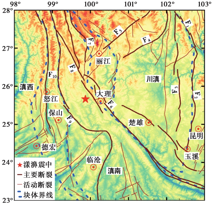
图1 研究区的地质构造简图 F1则木河断裂; F2普渡河断裂; F3安宁河断裂; F4金河-箐河断裂; F5丽江-小金河断裂; F6红河断裂; F7金沙江断裂; F8维西-乔后-巍山断裂; F9澜沧江断裂; F10怒江断裂
Fig. 1 Schematic tectonic map around the study area.
| 测量日期 | 测量期数 | 测点数 | 日变通化台 | Fσ/nT | Dσ/(') | Iσ/(') |
|---|---|---|---|---|---|---|
| 2018年4—5月 | 1 | 51 | LIJ | 0.31 | 0.11 | 0.06 |
| 2019年4—5月 | 2 | 54 | LIJ | 0.38 | 0.12 | 0.06 |
| 2020年4—5月 | 3 | 54 | LIJ | 0.31 | 0.10 | 0.07 |
| 2021年4—5月 | 4 | 54 | LIJ | 0.32 | 0.13 | 0.08 |
| 2021年5—6月 | 5 | 27 | LIJ | 0.47 | 0.17 | 0.08 |
表1 漾濞地区数据通化精度统计表
Table1 Accuracy statistical results of diurnal variation reduction in the Yangbi region
| 测量日期 | 测量期数 | 测点数 | 日变通化台 | Fσ/nT | Dσ/(') | Iσ/(') |
|---|---|---|---|---|---|---|
| 2018年4—5月 | 1 | 51 | LIJ | 0.31 | 0.11 | 0.06 |
| 2019年4—5月 | 2 | 54 | LIJ | 0.38 | 0.12 | 0.06 |
| 2020年4—5月 | 3 | 54 | LIJ | 0.31 | 0.10 | 0.07 |
| 2021年4—5月 | 4 | 54 | LIJ | 0.32 | 0.13 | 0.08 |
| 2021年5—6月 | 5 | 27 | LIJ | 0.47 | 0.17 | 0.08 |
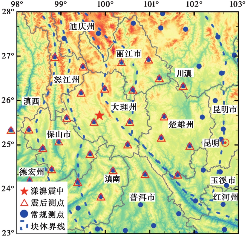
图2 研究区测点分布图
Fig. 2 Distribution of measurement stations in the study area.
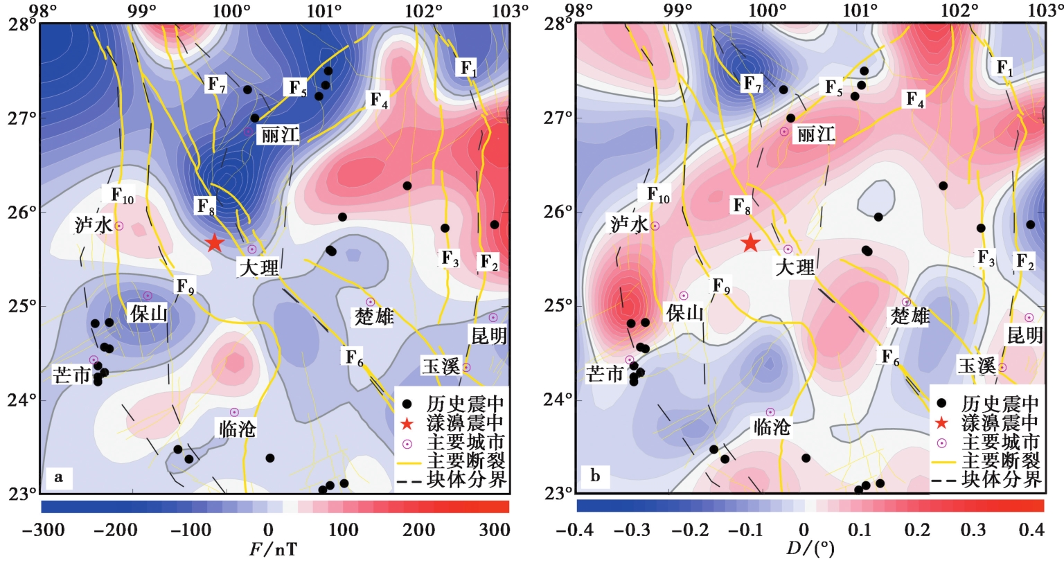
图3 2018.0岩石圈磁场空间分布图 a 地磁总强度; b 磁偏角
Fig. 3 Distribution of lithospheric magnetic field in the study area in 2018.0.
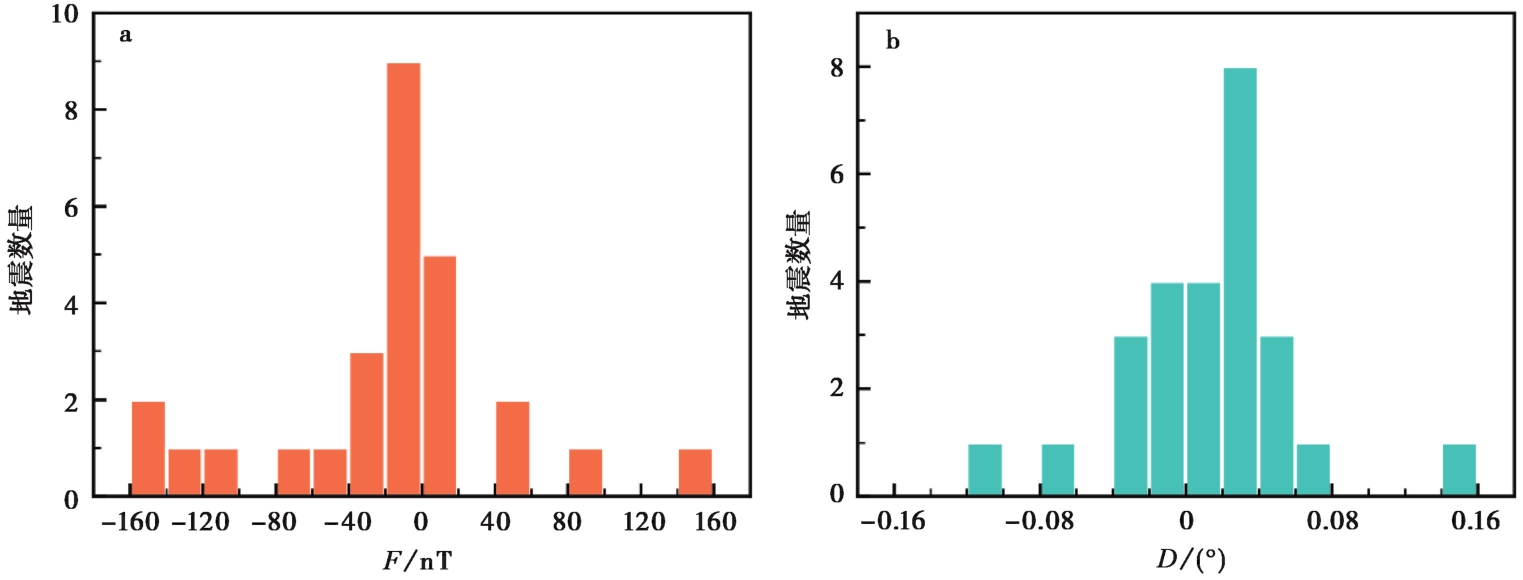
图4 1970—2021年MS≥6.0地震的震中统计分析 a 地磁总强度; b 磁偏角
Fig. 4 Statistical distribution of earthquake epicenters with MS≥6.0 from 1970 to 2021.
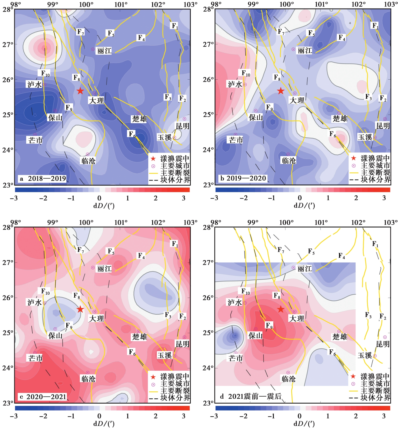
图5 岩石圈磁场磁偏角变化分布图 a 2018—2019年; b 2019—2020年; c 2020—2021年; d 2021年震前—震后
Fig. 5 Distribution of the declination variation.
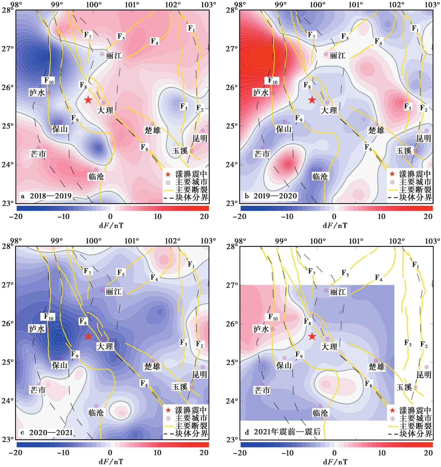
图6 岩石圈磁场地磁总强度变化分布图 a 2018—2019年; b 2019—2020年; c 2020—2021年; d 2021年震前—震后
Fig. 6 Distribution of the total intensity variation.
| [1] |
安振昌, 徐元芳, 夏国辉, 等. 1982. 表示局部地区地磁场及其长期变化分布的数学方法[J]. 地球物理学报, 25(S1): 711—717.
|
|
|
|
| [2] |
常祖峰, 常昊, 臧阳, 等. 2016. 维西-乔后断裂新活动特征及其与红河断裂的关系[J]. 地质力学学报, 22(3): 517—530.
|
|
|
|
| [3] |
陈斌, 袁洁浩, 王粲, 等. 2017. 流动地磁监测数据处理流程[J]. 地震研究, 40(3): 335—339.
|
|
|
|
| [4] |
邓起东, 张培震, 冉勇康, 等. 2002. 中国活动构造基本特征[J]. 中国科学(D辑), 32(12): 1020—1030.
|
|
|
|
| [5] |
丁新娟. 2017. 2015年新疆皮山6.5级地震前岩石圈磁场局部异常特征分析[J]. 地震研究, 40(3): 362—367.
|
|
|
|
| [6] |
董超, 陈斌, 袁洁浩, 等. 2021. 2021年5月22日玛多 MS7.4 地震震前岩石圈磁场变化特征分析[J]. 地震学报, 43(4): 453—462.
|
|
|
|
| [7] |
顾春雷, 张毅, 顾左文, 等. 2012. 华北地震区岩石圈磁异常场零值线与中强震震中分布关系[J]. 西北地震学报, 34(2): 174—179.
|
|
|
|
| [8] |
顾春雷, 张毅, 徐如刚, 等. 2010. 地震前后岩石圈磁场变化特征分析[J]. 地球物理学进展, 25(2): 472—477.
|
|
|
|
| [9] |
顾左文, 陈斌, 高金田, 等. 2009. 应用NOC方法研究中国地区地磁时空变化[J]. 地球物理学报, 52(10): 2602—2612.
|
|
|
|
| [10] |
顾左文, 张毅, 姚同起, 等. 2006. 九江-瑞昌 MS5.7 地震地磁异常的观测与分析[J]. 地震学报, 28(6): 611—621.
|
|
|
|
| [11] |
韩渭宾, 蒋国芳. 2004. 川滇地区强震活动分布特征及其与地壳块体构造背景关系的研究[J]. 地震学报, 26(2): 211—222.
|
|
|
|
| [12] |
皇甫岗, 秦嘉政, 李忠华, 等. 2007. 云南地震类型分区特征研究[J]. 地震学报, 29(2): 142—150.
|
|
|
|
| [13] |
李传友, 张金玉, 王伟, 等. 2021. 2021年云南漾濞6.4级地震发震构造分析[J]. 地震地质, 43(3): 706—721. doi: 10.3969/j.issn.0253-4967.2021.03.015.
|
|
DOI |
|
| [14] |
李家发, 吴一柱, 安振昌, 等. 1992. 中国地区地磁异常与地震分布关系[J]. 华南地震, 12(1): 11—16.
|
|
|
|
| [15] |
倪喆. 2014. 洱源5.5级地震前后地磁场变化异常特征分析[J]. 地震研究, 37(3): 426—432.
|
|
|
|
| [16] |
倪喆, 袁洁浩, 王粲, 等. 2014. 2014年云南鲁甸6.5级, 永善5.0级地震前岩石圈磁场局部异常特征分析[J]. 地震研究, 37(4): 537—541.
|
|
|
|
| [17] |
邱耀东. 2017. 联合Champ和Swarm卫星磁测数据反演中国大陆区域岩石圈磁场[D]. 武汉: 武汉大学.
|
|
|
|
| [18] |
宋成科, 张海洋. 2020. 2013年芦山 MS7.0 地震同震地磁变化分析[J]. 地震地质, 42(6): 1301—1315. doi: 10.3969/j.issn.0253-4967.2020.06.003.
|
|
DOI |
|
| [19] |
王月, 胡少乾, 何骁慧, 等. 2021. 2021年5月21日云南漾濞6.4级地震序列重定位及震源机制研究[J]. 地球物理学报, 64(12): 4510—4525.
DOI |
|
|
|
| [20] |
王朝景, 刘德强, 苏树朋, 等. 2021. 2018年永清 MW4.3 地震前后岩石圈磁场变化特征[J]. 地震地磁观测与研究, 42(3): 129—136.
|
|
|
|
| [21] |
吴富春, 米秋霞, 姬建中, 等. 1995. 中国及其邻区地震深度的特征[J]. 华北地震科学, 13(3): 21—27.
|
|
|
|
| [22] |
徐如刚, 张毅, 顾春雷, 等. 2010. 九江-瑞昌 MS5.7 地震前后地磁场水平分量异常追踪与分析[J]. 地球物理学进展, 25(4): 1175—1179.
|
|
|
|
| [23] |
易桂喜, 闻学泽, 苏有锦. 2008. 川滇活动地块东边界强震危险性研究[J]. 地球物理学报, 51(6): 1719—1725.
|
|
|
|
| [24] |
张国民, 汪素云, 李丽, 等. 2002. 中国大陆地震震源深度及其构造含义[J]. 科学通报, 47(9): 663—668.
|
|
|
|
| [25] |
张培震, 邓起东, 张国民, 等. 2003. 中国大陆的强震活动与活动地块[J]. 中国科学(D辑), 33(S1): 12—20.
|
|
|
|
| [26] |
|
| [27] |
|
| [28] |
|
| [1] | 张丽娟, 万永革, 王福昌, 靳志同, 崔华伟. 采用模糊聚类算法确定2021年漾濞地震序列的断层结构[J]. 地震地质, 2022, 44(6): 1634-1647. |
| [2] | 黄江培, 曹颖, 刘东, 郑秋月, 陈政宇, 王青华. 漾濞MS6.4地震前后的重力变化特征及其孕震含义分析[J]. 地震地质, 2022, 44(6): 1557-1573. |
| [3] | 石磊, 李永华, 张瑞青. 云南漾濞6.4级地震震源区及周边的重力均衡特征[J]. 地震地质, 2021, 43(5): 1140-1156. |
| [4] | 何欣娟, 潘华. 2021年云南漾濞MS6.4地震的强地面运动模拟[J]. 地震地质, 2021, 43(4): 920-935. |
| [5] | 陈鲲, 王永哲, 席楠, 卢永坤, 陆东华. 2021年5月21日云南漾濞6.4级地震的地震动强度图[J]. 地震地质, 2021, 43(4): 899-907. |
| [6] | 郭祥云, 尹海权, 汪贞杰, 杨辉. 2021年5月21日云南漾濞M6.4地震序列的矩心矩张量解及动力环境分析[J]. 地震地质, 2021, 43(4): 806-826. |
| [7] | 徐晓雪, 季灵运, 朱良玉, 王光明, 张文婷, 李宁. 漾濞MS6.4地震同震形变特征及发震构造探讨[J]. 地震地质, 2021, 43(4): 771-789. |
| [8] | 王绍俊, 刘云华, 单新建, 屈春燕, 张国宏, 解朝娣, 赵德政, 范晓冉, 华俊, 梁诗明, 张克亮, 代成龙. 2021年云南漾濞MS6.4地震同震地表形变与断层滑动分布[J]. 地震地质, 2021, 43(3): 692-705. |
| 阅读次数 | ||||||
|
全文 |
|
|||||
|
摘要 |
|
|||||
