地震地质 ›› 2024, Vol. 46 ›› Issue (2): 277-296.DOI: 10.3969/j.issn.0253-4967.2024.02.003
刘鑫1,2)( ), 王诗柔1)(), 石许华1,2),*(), 苏程1),*(), 鲁晨妍1), 钱晓园1), 孙侨阳1,2), 邓洪旦1,2), 杨蓉1,2), 程晓敢1,2)
收稿日期:2023-09-01
修回日期:2023-11-08
出版日期:2024-04-20
发布日期:2024-05-29
通讯作者:
*石许华, 男, 1982年生, 研究员, 博士生导师, 主要从事构造地貌、 活动构造和地震地质究, E-mail: 作者简介:刘鑫, 男, 1998年生, 现为浙江大学构造地质学专业在读博士研究生, 主要从事活动构造与地震地质研究, E-mail: xinliu0628@zju.edu.cn。
共同第一作者: 王诗柔, 女, 1999年生, 现为浙江大遥感与地理信息系统专业在读学博士研究生, 主要从事遥感方向深度学习研究, E-mail: wangshirou@zju.edu.cn。
基金资助:
LIU Xin1,2)(), WANG Shi-rou1)(), SHI Xu-hua1,2),*(), SU Cheng1),*(), LU Chen-yan1), QIAN Xiao-yuan1), SUN Qiao-yang1,2), DENG Hong-dan1,2), YANG Rong1,2), CHENG Xiao-gan1,2)
Received:2023-09-01
Revised:2023-11-08
Online:2024-04-20
Published:2024-05-29
摘要:
活动构造与地貌学主要涉及活动构造的运动学、 地貌的演化过程及其相关动力机制, 该研究方向是近几十年来地球系统科学交叉研究的热点之一。随着大数据与机器学习研究的发展, 活动构造与地貌学的研究和深度学习的结合已成为该领域中受到广泛关注的新兴研究方向, 并产出了大量优秀成果。文中总结并综述了现今深度学习在活动构造与地貌研究中的数据来源, 以及利用深度学习的方法定量化解决活动构造与地貌中的重要科学问题(包括冰川识别、 火山活动与地貌、 水系分析、 滑坡监测和地表形变等)。基于对上述实例的探索, 文中运用深度学习中的卷积神经网络, 对华南东南部福建地区的花岗岩岩石构造裂缝开展了基于高精度无人机航拍影像的深度学习自动识别。所搭建的卷积网络模型在55min的运行时间内自动识别出人工需消耗近一周才可识别的9 000余条裂缝, 并获得了85%的查准率与89%的查全率, 表明该模型在准确识别构造裂缝的同时显著提升了工作效率。文中最后讨论并展望了未来深度学习方法在活动构造与地貌学领域的发展前景。
刘鑫, 王诗柔, 石许华, 苏程, 鲁晨妍, 钱晓园, 孙侨阳, 邓洪旦, 杨蓉, 程晓敢. 深度学习在活动构造与地貌研究中的应用[J]. 地震地质, 2024, 46(2): 277-296.
LIU Xin, WANG Shi-rou, SHI Xu-hua, SU Cheng, LU Chen-yan, QIAN Xiao-yuan, SUN Qiao-yang, DENG Hong-dan, YANG Rong, CHENG Xiao-gan. APPLICATION OF DEEP LEARNING IN ACTIVE TECTONICS AND GEOMORPHOLOGY[J]. SEISMOLOGY AND GEOLOGY, 2024, 46(2): 277-296.
图1 用于深度学习的地质数据来源(改自Ma et al., 2021) a 野外地质调查; b 无人机调查; c 航空影像; d 遥感观测
Fig. 1 Source of geological data for deep learning(modified from Ma et al., 2021).
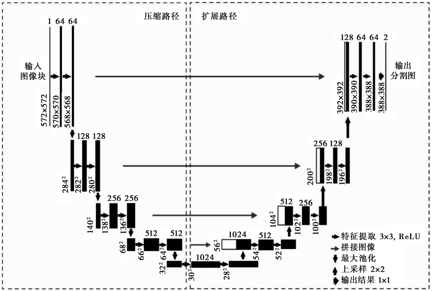
图2 U-Net模型示意图(改自Ronneberger et al., 2015) 图例中, 第1类向右箭头为通过卷积过程进行特征提取, 第2类向右箭头为拼贴图像过程; 向下箭头为池化过程, 以防出现过拟合; 向上箭头为上采样过程, 对原图像进行放大; 重叠双箭头为输出最终结果
Fig. 2 Schematic diagram of U-Net model(modified from Ronneberger et al., 2015).

图3 自编码器示意图(改自Skansi, 2018) 输入层接受数据并进行降维; 隐藏层发现数据特征; 输出层还原数据原始本构
Fig. 3 Schematic diagram of Autoencoder(modified from Skansi, 2018).
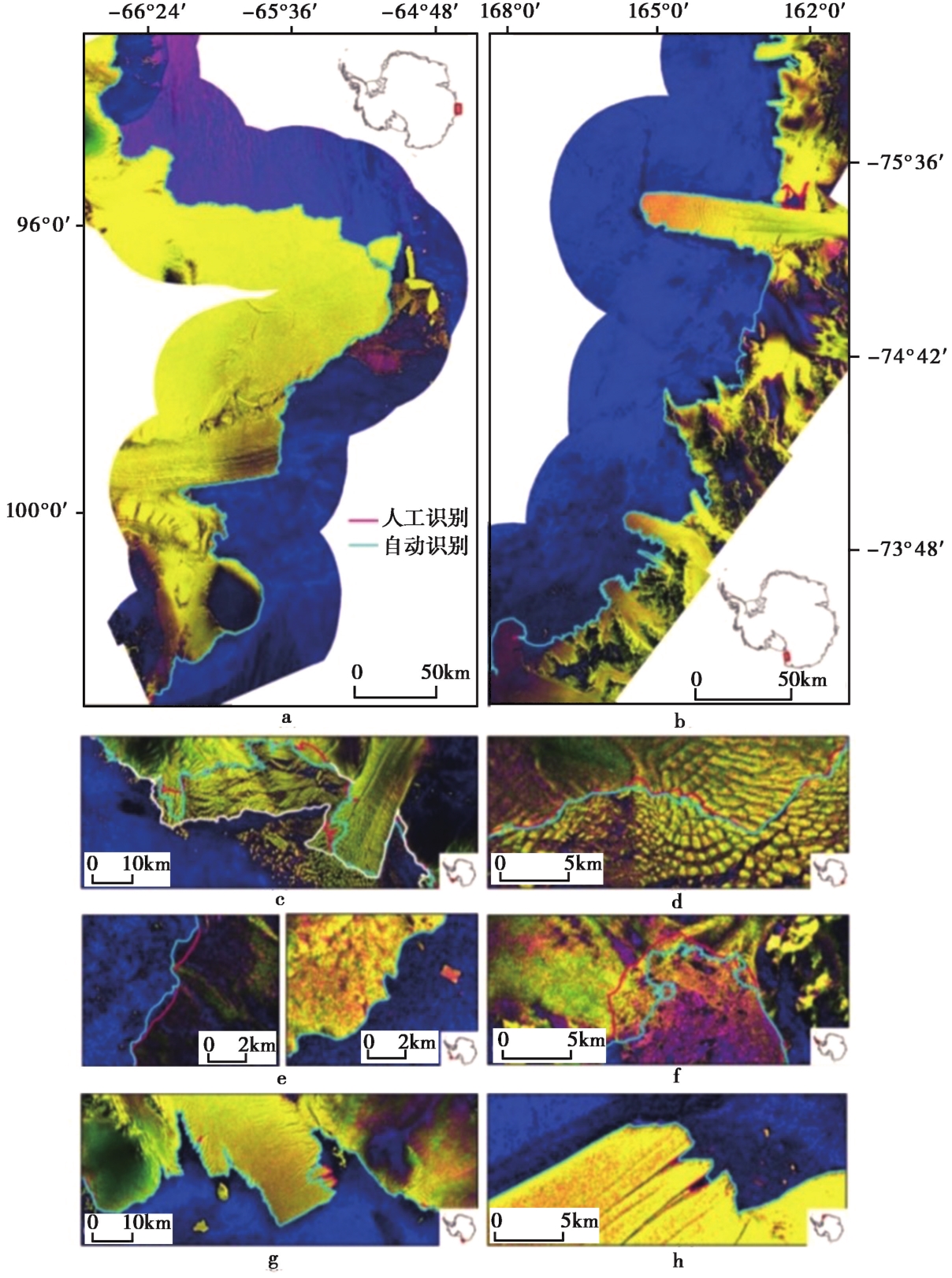
图4 训练和试验提取的南极不同地点的海岸线(Baumhoer et al., 2019) 红线和蓝线分别指示人工及CNN自动识别出的海岸线
Fig. 4 Training and testing extracted shorelines at different locations in Antarctica(Baumhoer et al., 2019).

图5 基于USGS数据样品的水系识别结果(Yu et al., 2022) 显示的数字代表识别概率
Fig. 5 Drainage pattern recognition results based on data samples from USGS(Yu et al., 2022).
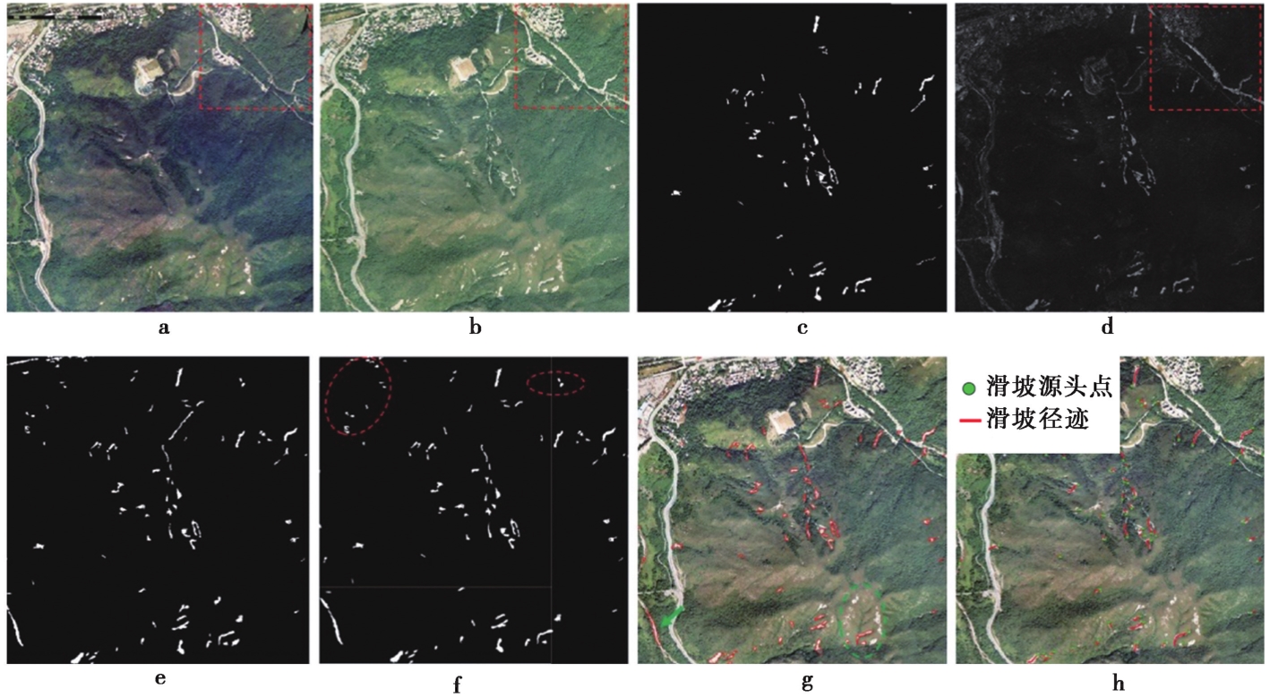
图6 大屿山地区的测试分区结果(Shi et al., 2020) a 滑坡事件前的航空正射像; b 滑坡事件后的航空正射像; c 参考地图; d 数字信号输入; e Shi等(2020)的CNN模型; f CDCNN模型分类后的二进制结果; g 将后期处理叠加在事件后图像上的最终结果; h 滑坡的径迹及源头
Fig. 6 Results of the testing zonation of Lantau district(Shi et al., 2020).
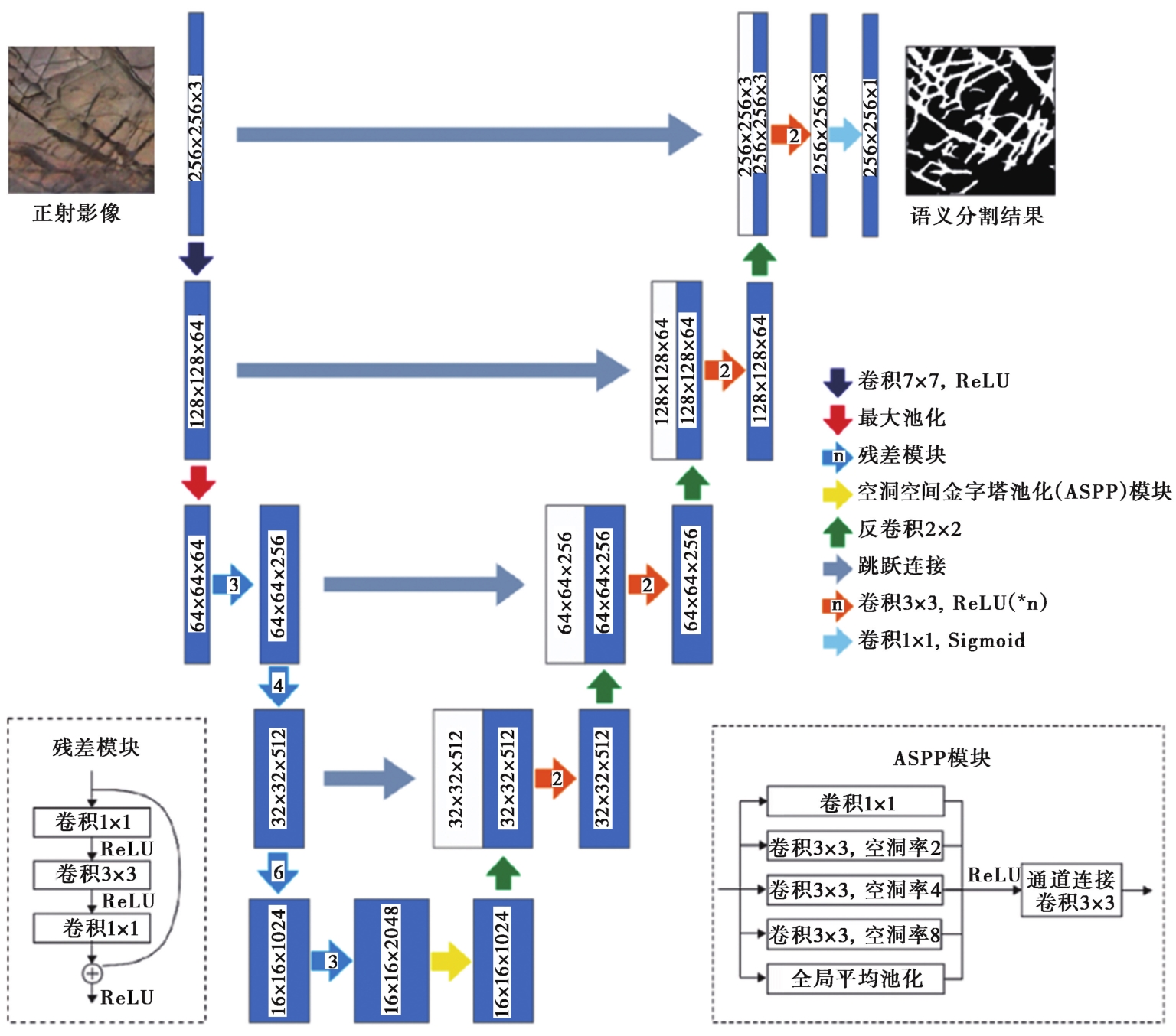
图7 基于多尺度特征提取的岩石裂缝提取卷积神经网络模型
Fig. 7 Convolutional neural network model for rock fracture extraction based on multi-scale feature extraction.

图8 岩石构造裂缝的识别 a 岩石构造裂缝正射影像; b 人工破裂填图; c 深度学习输出结果; d 图像后处理的提取结果
Fig. 8 Rock fracture identification.
| [1] |
邓起东. 2002. 中国活动构造研究的进展与展望[J]. 地质论评, 48(2): 168—177.
|
|
|
|
| [2] |
邓起东, 闻学泽. 2008. 活动构造研究: 历史, 进展与建议[J]. 地震地质, 30(1): 1—30.
|
|
|
|
| [3] |
邓起东, 张培震, 冉勇康, 等. 2003. 中国活动构造与地震活动[J]. 地学前缘, 10(S1): 66—73.
|
|
|
|
| [4] |
董传万, 周超, 顾虹艳, 等. 2011. 福建湄州岛镁铁质岩墙群与寄主花岗岩的形成时差、 地球化学及成因[J]. 吉林大学学报(地球科学版), 41(3): 735—744.
|
|
|
|
| [5] |
冯艳芳, 刘江涛, 刘勇, 等. 2022. 国内外基础地质数据更新现状与思考[J]. 地学前缘, 29(2): 370—377.
DOI |
|
|
|
| [6] |
舒远海, 石许华, 陈汉林, 等. 2022. 地壳均衡理论及其在构造地貌研究中的应用[J]. 地质论评, 68(4): 1171—1190.
|
|
|
|
| [7] |
王锦涵, 石许华, 陈汉林, 等. 2023. “V” 型共轭走滑断裂: 特征, 形成机制及其对青藏高原东南缘晚新生代变形的启示[J]. 地球科学, 48(4): 1421—1440.
|
|
|
|
| [8] |
叶青, 施和生, 梅廉夫, 等. 2017. 珠江口盆地珠一坳陷裂后期断裂作用: 迁移、 转换及其动力学[J]. 地球科学, 42(1): 105—118.
|
|
|
|
| [9] |
曾宪阳, 刘静, 王伟, 等. 2023. 基于机器学习的地表破裂自动识别和填图: 以2021年青海玛多 MW7.4 地震为例[J]. 地球物理学报, 66(3): 1098—1112.
|
|
|
|
| [10] |
张敏, 旷健, 肖志才, 等. 2021. 广东惠州燕山期以来地质构造演化: 对华南构造的新启示[J]. 地球科学, 46(1): 242—258.
|
|
|
|
| [11] |
周永章, 左仁广, 刘刚, 等. 2021. 数学地球科学跨越发展的十年: 大数据、 人工智能算法正在改变地质学[J]. 矿物岩石地球化学通报, 40(3): 556—573, 777.
|
|
|
|
| [12] |
左仁广, 彭勇, 李童, 等. 2021. 基于深度学习的地质找矿大数据挖掘与集成的挑战[J]. 地球科学, 46(1): 350—358.
|
|
|
|
| [13] |
|
| [14] |
|
| [15] |
|
| [16] |
|
| [17] |
|
| [18] |
|
| [19] |
|
| [20] |
|
| [21] |
|
| [22] |
|
| [23] |
|
| [24] |
|
| [25] |
|
| [26] |
|
| [27] |
|
| [28] |
|
| [29] |
|
| [30] |
|
| [31] |
|
| [32] |
|
| [33] |
|
| [34] |
|
| [35] |
DOI PMID |
| [36] |
|
| [37] |
|
| [38] |
|
| [39] |
|
| [40] |
|
| [41] |
|
| [42] |
|
| [43] |
|
| [44] |
|
| [45] |
|
| [46] |
|
| [47] |
|
| [48] |
|
| [49] |
|
| [50] |
|
| [51] |
|
| [52] |
|
| [53] |
|
| [54] |
|
| [55] |
|
| [56] |
|
| [57] |
|
| [58] |
|
| [59] |
|
| [60] |
|
| [61] |
|
| [62] |
|
| [63] |
|
| [64] |
|
| [65] |
|
| [66] |
|
| [67] |
|
| [68] |
|
| [69] |
|
| [70] |
|
| [1] | 庞桢辉, 徐皓婷, 石许华, 葛进, 李丰. 陡坎地貌定年理论及其在活动构造与地貌学研究中的应用[J]. 地震地质, 2024, 46(2): 251-276. |
| [2] | 张玲, 苗树清, 杨晓平. 基于ArcGIS平台的天山北麓活动逆断层智能化提取方法的研究与实现[J]. 地震地质, 2023, 45(2): 422-434. |
| [3] | 张苏祥, 盛书中, 席彪, 房立华, 吕坚, 王甘娇, 张潇. 基于改进的DBSCAN算法自动识别断层方法研究及其在唐山地区的应用[J]. 地震地质, 2022, 44(6): 1615-1633. |
| [4] | 徐伟, 刘志成, 王继, 高战武, 尹金辉. 西藏阿里地区喀喇昆仑断裂断错地貌及最近强震活动时代的初步研究[J]. 地震地质, 2022, 44(4): 925-943. |
| [5] | 卢本添, 李志刚, 梁浩, 杨敬钧, 郑文俊. 中条山北麓河流地貌特征及其对断裂构造演化的响应[J]. 地震地质, 2022, 44(4): 961-975. |
| [6] | 叶雨晖, 吴磊, 王依平, 楼谦谦, 陈力琦, 高石宝, 林秀斌, 程晓敢, 陈汉林. 北阿尔金断裂晚第四纪活动构造特征[J]. 地震地质, 2022, 44(2): 297-312. |
| [7] | 周少辉, 蒋海昆, 李健, 曲均浩, 郑晨晨, 李亚军, 张志慧, 郭宗斌. 基于深度学习的地震事件分类识别——以山东地震台网记录为例[J]. 地震地质, 2021, 43(3): 663-676. |
| [8] | 陈晓利, 刘春国, 传一健, 兰剑, 魏延坤. 鲁甸地震的滑坡物质运移规律与地形特征[J]. 地震地质, 2021, 43(1): 92-104. |
| [9] | 周朝, 何宏林, 魏占玉, 苏鹏, 任光雪. 地貌参数方法在小尺度地貌研究中的应用——以北天山独山子背斜为例[J]. 地震地质, 2020, 42(6): 1492-1508. |
| [10] | 唐清, 郑文俊, 石霖, 张冬丽, 黄荣. 基于高精度LiDAR数据的断裂活动习性精细定量——以香山-天景山断裂景泰小红山段为例[J]. 地震地质, 2020, 42(2): 366-381. |
| [11] | 苏强, 任俊杰, 梁欧博, 郭菲. 基于ALOS PALSAR影像的莫勒切河洪积扇地貌面定量分期[J]. 地震地质, 2020, 42(1): 79-94. |
| [12] | 魏聪敏, 葛伟鹏, 张波. 利用地貌形态估算西秦岭-松潘构造结及邻区的下地壳黏滞系数[J]. 地震地质, 2020, 42(1): 163-181. |
| [13] | 孙稳, 何宏林, 魏占玉, 高伟, 孙浩越, 邹俊杰. 基于无人机航测获取高分辨率DEM数据的断层几何结构精细解译与分析——以海原断裂唐家坡为例[J]. 地震地质, 2019, 41(6): 1350-1365. |
| [14] | 刘睿, 姜大伟, 李安, 郭长辉, 张世民. 利用沉积物粒度特征区分不同级地貌面的方法对比——以青衣江流域地貌面为例[J]. 地震地质, 2019, 41(4): 837-855. |
| [15] | 任光雪, 李传友, 吴传勇, 汪思妤, 张会平, 任治坤, 李新男. 东天山包尔图断裂带晚第四纪运动性质及形成机制[J]. 地震地质, 2019, 41(4): 856-871. |
| 阅读次数 | ||||||
|
全文 |
|
|||||
|
摘要 |
|
|||||
